78 Fires & 19 Near Misses in Heritage Buildings Recorded
on the 2019 Database in January & February.
(A Fire is defined as an uncontrolled and unwanted burning event (including explosion) causing damage to a heritage building and/or contents by at least one of the following: flame, heat, smoke or blast)
(A Near Miss is defined as an event in a heritage building that had the potential to start a fire, or a fire adjacent to a heritage building that, without intervention, could have spread to that building)
Fires Index < Click here
hOME / About / Places of Worship / Heritage Buildings / Domestic listed properties / Country estates / grant /CONTACT US / Fires
|
“You see all these old buildings ... catching fire overnight, and it is so sad. I am very connected with these buildings because they are our history. It is the only one that we have.”
Sônia Braga - Actress |
Subscribe to our newsletterOur January Newsletter is out now with articles on all things related to fires, fire prevention, protection and restoration of heritage buildings - See this and our previous Newsletters HERE. "Our Heritage Under Fire" brings interesting, informative and enlightening news and comment for everyone who has an interest in the protection of the UKs built heritage.
Subscribe by clicking the button below to be added to our mailing list. Don't miss an issue. You are signing up only to receive our newsletter, we will not use your contact details, nor pass them on to third parties, for any other purpose. You may unsubscribe from the list at any time. |
Click on the HEADLINE to expand the article.
Heritage & Ecclesiastical Fire Protection
Preventing Fire, Protecting Life, Preserving Heritage
Click HERE for Expert Specialist Fire Safety Risk Assessments for Historic and Listed Buildings
Preventing Fire, Protecting Life, Preserving Heritage
Click HERE for Expert Specialist Fire Safety Risk Assessments for Historic and Listed Buildings
Phone: 07840 351458 Email: hello@fireprotect.me.uk
February - 37 Fires & 8 Near Misses
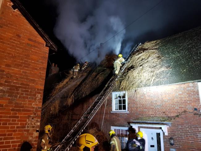
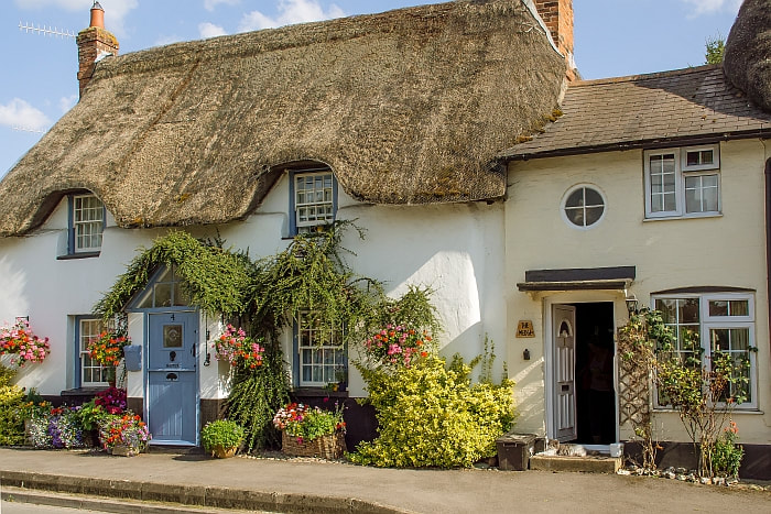
27 February 2019 (18:00*) - Fire reported at thatched house in Church Street, Cranborne
More than 70 firefighters tackled a blaze at a home in Cranborne yesterday evening. The fire has affected a thatched cottage in Church Street. Ten fire engines were called to the scene and 75 firefighters worked in "demanding conditions" to get the blaze under control, according to a Dorset and Wiltshire Fire Control spokesperson. The B3078 was closed through the village while crews deal with the incident. The fire service was called at around 6pm.
Residents were asked to stay indoors and keep windows and doors closed due to smoke. People were urged to avoid the area due to the number of fire engines in attendance. Half an hour after fire crews were called to the incident, a single-vehicle crash was reported in Castle Street in Cranborne. Firefighters made sure nobody was trapped in the vehicle. A male casualty was taken to hospital.
Shortly before 10pm, the fire service said crews would be "scaling down attendance in the next hour. Despite damage to thatched roof, firefighters successfully avoided significant fire damage to the rest of the property and worked hard to salvage all of the owners' possessions," the service said in a tweet.
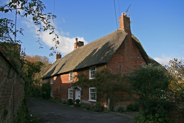
The two semi-detached thatched cottages on Church Street were once a single house. It is Grade II listed and dates back to the 15th century when it was probably an open hall. As with any building this old, it has undergone alterations through the centuries but still retained many of its original features. The cottage lies within Cranborne Conservation Area.
News Source: Daily Echo
Residents were asked to stay indoors and keep windows and doors closed due to smoke. People were urged to avoid the area due to the number of fire engines in attendance. Half an hour after fire crews were called to the incident, a single-vehicle crash was reported in Castle Street in Cranborne. Firefighters made sure nobody was trapped in the vehicle. A male casualty was taken to hospital.
Shortly before 10pm, the fire service said crews would be "scaling down attendance in the next hour. Despite damage to thatched roof, firefighters successfully avoided significant fire damage to the rest of the property and worked hard to salvage all of the owners' possessions," the service said in a tweet.
The two semi-detached thatched cottages on Church Street were once a single house. It is Grade II listed and dates back to the 15th century when it was probably an open hall. As with any building this old, it has undergone alterations through the centuries but still retained many of its original features. The cottage lies within Cranborne Conservation Area.
News Source: Daily Echo
Listing Details
|
Entry Name: 1, Church Street
Listing Date: 3 April 1986 Grade: II Source: Historic England Source ID: 1323499 English Heritage Legacy ID: 107356 Location: Cranborne, East Dorset, Dorset, BH21 County: Dorset District: East Dorset Civil Parish: Cranborne Built-Up Area: Cranborne Traditional County: Dorset Lieutenancy Area (Ceremonial County): Dorset Church of England Parish: Cranborne with Boveridge St Mary and St Bartholomew Church of England Diocese: Salisbury |
Coordinates
Latitude: 50.9188 / 50°55'7"N Longitude: -1.9229 / 1°55'22"W OS Eastings: 405512 OS Northings: 113266 OS Grid: SU055132 Mapcode National: GBR 41P.6NF Mapcode Global: FRA 66VP.4N5 |
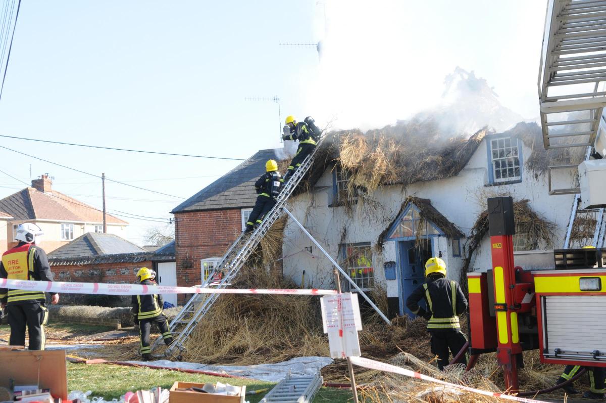
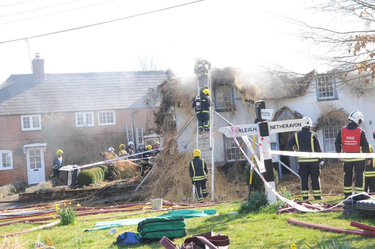
26 February 2019 (09:18) - Serious thatch fire in Haxton village
A total of 20 fire engines are in attendance at the blaze near Netheravon. The thatch fire was reported to emergency services at 9.18am this morning (Tuesday February 26th). 15 appliances from Dorset and Wiltshire Fire and Rescue and a further 5 from Hampshire are dealing with it at the moment.
Around 100 firefighters are currently on the scene. Luckily, it's not believed that anyone's been hurt. The severity of the blaze means some road closures have had to be put in place. Wiltshire Police tell us that the High Street in Haxton is closed, between the Mill Road and Lower Street junctions. The closure's been put in place due to the large number of vehicles in the area.
The house is known as Magpies Cottage and was built in the late 18th century. It is Grade II listed and lies within the Fittleton & Haxton Conservation Area.
News Source: Spire FM

Listing Details
|
Entry Name: Magpies Cottage
Listing Date: 3 June 1986 Grade: II Source: Historic England Source ID: 1033944 English Heritage Legacy ID: 311016 Location: Fittleton, Wiltshire, SP4 County: Wiltshire Civil Parish: Fittleton Built-Up Area: Netheravon Traditional County: Wiltshire Lieutenancy Area (Ceremonial County): Wiltshire Church of England Parish: Fittleton All Saints Church of England Diocese: Salisbury |
Coordinates
Latitude: 51.243 / 51°14'34"N Longitude: -1.7888 / 1°47'19"W OS Eastings: 414838 OS Northings: 149339 OS Grid: SU148493 Mapcode National: GBR 4Z9.4JG Mapcode Global: VHB54.Y06X |
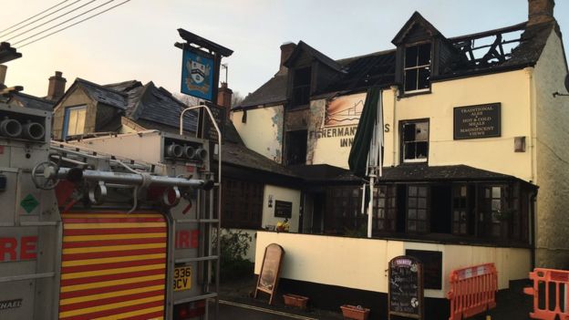
25 February 2019 (00:48) - Newlyn family lost everything in historic pub fire
The loss of an historic pub in Newlyn from a fire in the early hours has shocked the close-knit community. Fire has gutted the Fisherman’s Arms Inn on Cliff Road. Witnesses reported seeing flames leaping from the roof during the blaze in the early hours of Monday morning. There was immediate concern for the owners, Sally and Dave Reed, who were taken to hospital following the blaze as a precaution after breathing in smoke.
At 12.48am Cornwall Fire and Rescue Service Critical Control Centre received numerous calls reporting a fire in a property in Fore Street. Appliances from Penzance, St Just, St Ives, Tolvaddon, Hayle, Truro and Helston, along with officers and support vehicles were in attendance. A neighbouring house lost roof tiles and suffered water damage. Devon and Cornwall Police said that a number of nearby properties "were evacuated as a precaution" and roads remain closed in the area.
Newlyn residents speaking outside the damaged pub said the owners were ok but the concern now was for their dog, which had not been seen since. Vicky White has also set up a fundraising page to help the family. She said: “If you can help by donating, please do, this family have two boys and have lost everything including their livelihood.”
Abe Richardson, who lives near the pub, said he was stunned at the scale of the damage and saddened that so much of Newlyn’s history had been lost. He said: “The ceiling was covered in fishing memorabilia and antiquities which have been donated over the years. There’s even an old World War Two German bomb which was found, defused, down at Sandy Cove. It’s part of Newlyn. I am gob-smacked. When someone says to you such and such has burned down you’re thinking ‘yeah, but…’ – because people like to embellish things – but the way that [fire] has gone through the roof, that’s some serious heat. It’s a dead shame. I am in shock.”
The Fishermans Arms Inn is a 17th. Century building which was (and probably still is) the haunt of the Newlyn fishermen).It lies within the Newlyn Conservation Area.
News Source: Cornwall Live

Near Miss
24 February 2019 (21:10) - ‘Disgusting’ vandals blasted for burning bins in Kilwinning Abbey
24 February 2019 (21:10) - ‘Disgusting’ vandals blasted for burning bins in Kilwinning Abbey
A concert had to be stopped after a blue bin was burnt out by youths in Kilwinning’s Abbey church grounds. A winter concert by the Ayr String Band on Sunday night was interrupted just 10 minutes in after the incident on Sunday evening [February 24] just after 9pm. This follows recent complaints at the town's community council of burning bins and damage to the war memorial in the Abbey.
Kilwinning Community Council Secretary Nairn McDonald said: "It's really upsetting to have to pause the concert due to wheelie bins being set ablaze in the Abbey Ground. This is not only criminal vandalism but it is incredibly dangerous and deeply disrespectful. It's clearly a small minority who are doing this but people in the community must know who they are so they need to be active and report it to police. People clearly know who they are because they'll be going home stinking of the fumes and there's not much the police can do if they don't know who that is. Not only is it disgusting and disrespectful to be doing that in a historic church ground but also it's a graveyard, people are buried in there, it's the height of disrespect."
This follows similar acts of vandalism raised with police at the meeting of Kilwinning Community Council last week. Community Councillor Janey Grier said: "There was at least one blue bin set on fire in the Abbey grounds on Friday (February 15) it was absolutely dreadful. It was just burnt out and the contents of it had been burnt out in the Abbey as well it was really shocking." Community Councillor Jim Watson said: "I walked through the Abbey grounds today (Thursday, February 21) and someone has been trying to damage the base of the war memorial by throwing stones where the names are on it, it’s really quite disturbing to see that. It’s very disrespectful. Again it’s dark, it’s a very difficult area to police but I find it very disturbing that people would be so disrespectful." Police have confirmed they have been speaking to Kilwinning Community Council regarding the vandalism incidents. Anyone with information should call Police on 101.
The Parish Church of Kilwinning is Category B listed was built by John Garland and John Wright and completed in 1774. It stands on the site of an earlier sixteenth century church which in turn was located within the ruins of Kilwinning Abbey. The Abbey was founded in 1188. Many stones from the old Abbey were re-used, and these are easily seen by the uneven surface of some of the outer walls. It therefore has a history that goes back over 800 years on this site. However there is also a connection with the Celtic church which takes it back over 1400 years. The congregation is now known as Kilwinning Old Parish Church of Scotland. The church building still tends to be known as the Abbey Church. There is also a Category B listed detached Gothic Revival church tower erected in 1815 on the site of a mediaeval one. The Abbey ruins are Category A listed and also a Scheduled Ancient Monument.
News Source: Irvine Times

Listing Details
|
Entry Name: Kilwinning Abbey Church and churchyard excluding scheduled monument number SM90187
Listing Date: 14 April 1971 Last Amended: 12 January 2018 Category: B Source: Historic Scotland Source ID: 380969 Historic Scotland Designation Reference: LB36235 Building Class: Cultural Location: Kilwinning County: North Ayrshire Electoral Ward: Kilwinning Traditional County: Ayrshire Entry Name: Detached Church Tower Listing Date: 14 April 1971 Category: B Source: Historic Scotland Source ID: 380971 Historic Scotland Designation Reference: LB36236 Building Class: Cultural Location: Kilwinning County: North Ayrshire Electoral Ward: Kilwinning Traditional County: Ayrshire Entry Name: Kilwinning Abbey Listing Date: 14 April 1971 Category: A Source: Historic Scotland Source ID: 380972 Historic Scotland Designation Reference: LB36237 Building Class: Cultural Location: Kilwinning County: North Ayrshire Electoral Ward: Kilwinning Traditional County: Ayrshire |
Coordinates
Latitude: 55.6535 / 55°39'12"N Longitude: -4.6984 / 4°41'54"W OS Eastings: 230321 OS Northings: 643294 OS Grid: NS303432 Mapcode National: GBR 37.JT4D Mapcode Global: WH2NW.S5W9 Latitude: 55.6534 / 55°39'12"N Longitude: -4.6991 / 4°41'56"W OS Eastings: 230277 OS Northings: 643294 OS Grid: NS302432 Mapcode National: GBR 37.JSZ6 Mapcode Global: WH2NW.S5JB Latitude: 55.6533 / 55°39'11"N Longitude: -4.6983 / 4°41'53"W OS Eastings: 230324 OS Northings: 643274 OS Grid: NS303432 Mapcode National: GBR 37.JT5R Mapcode Global: WH2NW.S5WG |
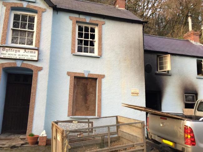
24 February 2019 (12:05) - A blaze has caused significant damage at a famous north Pembrokeshire pub.
Fire crews from Haverfordwest and Fishguard were called to the Dyffryn Arms, known locally as ‘Bessie’s’ in Cwm Gwaun this afternoon (Sunday). Significant interior damage has been reported in the bar and living areas of the Grade II listed two-storey pub, and the road was closed while the emergency crews dealt with the incident. Firefighters arrived at the scene at 12.05pm and used hose-reel jets, breathing apparatus and thermal imaging cameras to tackle the blaze.
Landlady 88 year-old Bessie Davies is understood to be shocked but uninjured, and was taken to a nearby relative’s home after getting out of the property and raising the alarm. The cause of the fire is not yet known and the building was boarded up once safe to do so. The shocked community has offered messages of support on social media. A family member issued the following statement on Facebook this afternoon: “Fire has been at Bessie's. Mam and everyone out safely. Pub closed for the foreseeable future.”
The Good Pub Guide describes the Dyffryn Arms as, “A classic rural time warp known locally as Bessie's after the much-loved veteran landlady, (her farming family have run it since the 1840s and she's been in charge for well over a third of that time); It has a basic 1920s front parlour with plain deal furniture and draughts boards inlaid into tables, red and black quarry tiles, woodburner, well kept Bass served by jug through sliding hatch, low prices, World War I prints and posters, a young portrait of the Queen and large collection of banknotes, darts; duck eggs for sale; lovely outside view and walks in nearby Preseli Hills, open more or less all day (may close if no customers)”
It was listed for its special architectural and historic interest as a very rare survival of a rural pub in a mid C19 building of late Georgian pattern, typical of this period and retaining good historical detailing. It represents a once common building type across the British Isles that has now been almost completely lost.
News Source: Western Telegraph
Fire damage at the Dyffryn Arms Public House
Listing Details
|
Entry Name: Dyffryn Arms Public House
Listing Date: 9 May 2016 Grade: II Source: Cadw Source ID: 87708 Building Class: Recreational Location: In the centre of the hamlet of Pontfaen, near to the Picton Mill Bridge. County: Pembrokeshire Community: Cwm Gwaun Community: Cwm Gwaun Locality: Pontfaen Traditional County: Pembrokeshire |
Coordinates
Latitude: 51.9698 / 51°58'11"N Longitude: -4.8745 / 4°52'28"W OS Eastings: 202639 OS Northings: 234055 OS Grid: SN026340 Mapcode National: GBR CP.L5KX Mapcode Global: VH1QP.GRD9 |
24 February 2019 (10:55) - Firefighters tackle blaze at popular city centre restaurant
Firefighters are tackling a fire in Cambridge city centre (February 24). Part of the Market square has been cordoned off while fire crews work to extinguish the blaze near Franco Manca. Photos from the incident show two fire engines in attendance, they appear to be tackling a fire just outside of the popular pizza restaurant. There are road closures in and around the market square. Those out and about in Cambridge this afternoon are being asked to avoid the area if possible.
A spokeswoman for Cambridgeshire fire and rescue said: “Crews are currently tackling a fire in Cambridge city centre. It was first reported to us at 10.55am and it was reports of smoke coming from the roof of Franco Manca.” Two crews were still dealing with the fire at 2.30pm. Market square re-opened just after 5pm.
The restaurant occupies a Grade II listed building, built in about 1840 as a house and shop. It lies within the Central Conservation Area.
News Source: Cambridgeshire Live
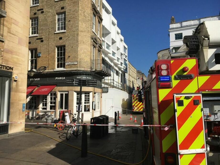
There were reports of smoke coming from the roof of Franco Manca
Listing Details
|
Entry Name: 15, Market Hill
Listing Date: 25 October 1989 Grade: II Source: Historic England Source ID: 1265292 English Heritage Legacy ID: 47923 Location: Cambridge, Cambridgeshire, CB2 County: Cambridgeshire District: Cambridge Town: Cambridge Electoral Ward/Division: Market Built-Up Area: Cambridge Traditional County: Cambridgeshire Lieutenancy Area (Ceremonial County): Cambridgeshire Church of England Parish: Cambridge St Mary the Great with St Michael Church of England Diocese: Ely |
Coordinates
Latitude: 52.2058 / 52°12'20"N Longitude: 0.1191 / 0°7'8"E OS Eastings: 544902 OS Northings: 258516 OS Grid: TL449585 Mapcode National: GBR L79.LY2 Mapcode Global: VHHK3.0TTD |
23 February 2019 (22:45) - Firefighters tackle blaze at historic Dunston Staiths which is left 'damaged' by third fire
Part of the historic Dunston Staiths has been severely damaged in a fire which broke out overnight. Three fire engines and the fire boat were called out to a blaze on the timber jetty on the Tyne at around 10.45pm on Saturday. A total of 17 firefighters were at the scene as the fire took hold on the lower and upper level. Ten timber structural beams on the 126-year-old structure were also damaged by the fire, which was extinguished using a jet. Volunteers who have helped restore the site have reacted with fury. A crew from Byker station posted on Twitter: "Our fire boat was called into action tonight to help crews from Newcastle and Gateshead extinguish a large fire on the Dunston Staiths. We were also there for safety as there were firefighters working above the water, high up on the staiths."
The Grade II listed structure was built in 1893 by the North East Railway Company to allow large quantities of coal arriving by rail from the Durham Coalfields to be loaded directly onto waiting colliers (coal ships). The 520m (1,709ft)-long structure, believed to be the largest of its kind in Europe, played a crucial role in the transportation of millions of tons of North East coal from the Tyne. The 1920s saw 140,000 tons of coal a week loaded at Dunston - the last working staiths on the Tyne - but by the 1970s, this had fallen to just 3,000 tons. In 1980, the staiths loaded its final shipment and was closed. In 1990 the listed structure was rebuilt as a tourist attraction at the National Garden Festival.
Labour councillor for Dunston and Teams, Brenda Clelland, said: "I'm devastated and appalled at what has happened. Someone has been absolutely determined to do this, you would have to work really hard to get that type of wood to catch fire. It's happened before but it's truly shocking." Andrew Smith is a member of the Friends of the Dunston Staiths volunteer group. He said: "It's a very important part of our region's history and has protected status. It's already on the 'at risk' list because of its age and somewhere around £400,000 has been spent restoring it in recent years. This sort of vandalism is immensely frustrating and very disheartening. We're going to have to look again at security and installing cameras to protect it." It's not the first time a fire has broken out at Dunston Staiths. A blaze partially destroyed it in 2003 and it was hit again in 2010 by another suspected arson attack. It is not currently known if a fire investigation will take place.
News Source: Chronicle Live
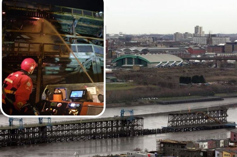
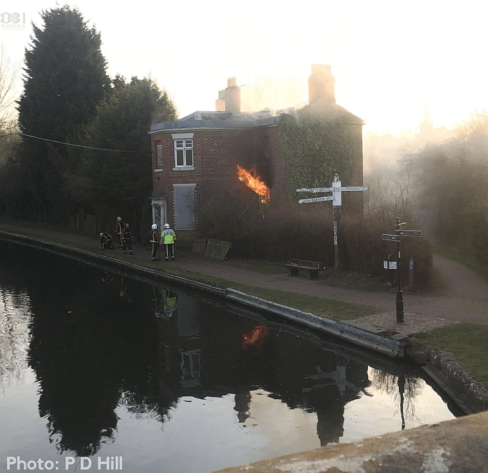
Fire crews tackle a fire on Dunston Staiths
Listing Details
|
Entry Name: River Tyne Dunston Coal Staithes
Listing Date: 13 January 1983 Grade: II Source: Historic England Source ID: 1248994 English Heritage Legacy ID: 430242 Location: Gateshead, NE8 County: Gateshead Electoral Ward/Division: Dunston and Teams Built-Up Area: Gateshead Traditional County: Durham Lieutenancy Area (Ceremonial County): Tyne and Wear Church of England Parish: Bensham and Teams Church of England Diocese: Durham |
Coordinates
Latitude: 54.9581 / 54°57'29"N Longitude: -1.6331 / 1°37'59"W OS Eastings: 423592 OS Northings: 562666 OS Grid: NZ235626 Mapcode National: GBR SLF.LY Mapcode Global: WHC3Q.WMHX |
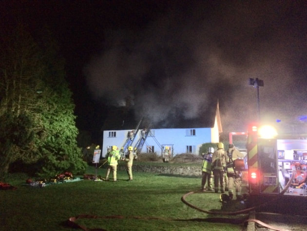
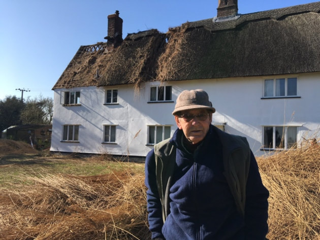
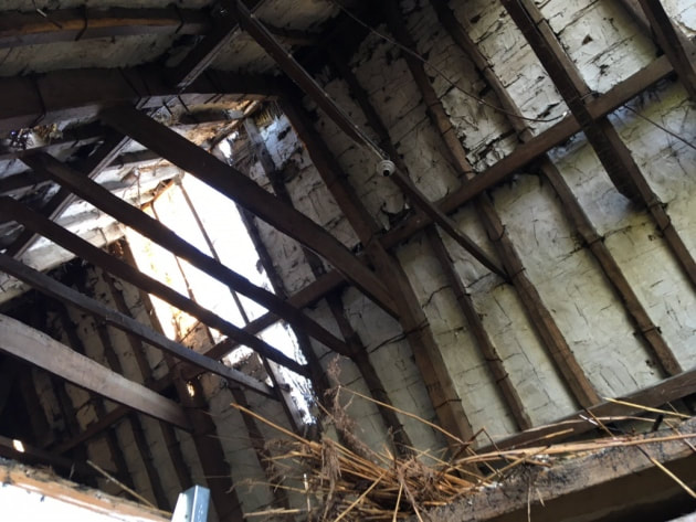
23 February 2019 (19:30*) - Family left heartbroken following thatch blaze
A heartbroken family who watched a fire rip through the roof of their farmhouse say it no longer feels like home. About 60 firefighters battled the thatch blaze at the Grade II listed White House Farmhouse in Bergh Apton Road, Mundham, on Saturday night, with fire crews remaining on scene until 1.50am. Richard Key, 76, who has lived at the farmhouse with his wife Margaret for 55 years, said he was devastated by the fire.
Mr Key was watching television in his lounge when his nephew Simon started banging on the door to tell him his thatched roof was alight. “I did not believe him at first because I could not smell any smoke but I went outside and was shocked to see the flames,” he said. “After we called the fire service Simon went up the ladder to pat the fire down and we thought we had stopped it.” Ten crews of firefighters from both Norfolk and Suffolk arrived on scene by 7.30pm as the blaze continued to grow. Mr Key’s son, Wes, 40, described his shock at seeing the house he has lived in all his life damaged by the flames. He said: “Once I got outside I was shaking and in a bad way. I have had so many memories here so it was heartbreaking to see. It no longer feels like home.”
The building dates back to the 17th Century. Mr Key’s grandfather Frederick lived in the farmhouse - which was formerly two separate cottages - almost 200 years ago and it has been kept in the family ever since. The 76-year-old said: “I am just relived nobody has been hurt. Without the brilliant efforts of the firefighters the damage could have been much worse.” Despite many of the carpets in the house suffering water damage, all other valuables within the property are thought to be unscathed. The thatch at one end of the house has been torn through, leaving the beams totally exposed and there is a clear fire break cut down the middle of the roof. Having slept in his bedroom - at the other end of the farmhouse - on Saturday night, Mr Key is determined not to have to move out while the clean up continues. “I love it here, it is usually very quiet and peaceful which means I can just go about my day to day business of farming,” he said. “So long as it is safe I will be staying here.”
News Source: Eastern Daily Press

Listing Details
|
Entry Name: White House Farmhouse
Listing Date: 5 September 1960 Grade: II Source: Historic England Source ID: 1372854 English Heritage Legacy ID: 227389 Location: Mundham, South Norfolk, Norfolk, NR14 County: Norfolk District: South Norfolk Civil Parish: Mundham Traditional County: Norfolk Lieutenancy Area (Ceremonial County): Norfolk Church of England Parish: Mundham St Peter Church of England Diocese: Norwich |
Coordinates
Latitude: 52.53 / 52°31'48"N Longitude: 1.4398 / 1°26'23"E OS Eastings: 633415 OS Northings: 298022 OS Grid: TM334980 Mapcode National: GBR WK3.BV6 Mapcode Global: VHM62.XN1V |
23 February 2019 (02:30) - Fire at guest house on Froghall Lane
Firefighters tackled a blaze at a B&B in Bewsey in the early hours of this morning. Five fire engines were called to the Holly Lodge Guest House on Froghall Lane shortly before 2.30am today, Saturday. A fire had been started in the basement of the property, but all persons inside the hotel were accounted for.
Holly Lodge is a detached Grade II listed red brick Victorian Gothic villa.
News Source: Warrington Guardian
Holly Lodge is a detached Grade II listed red brick Victorian Gothic villa.
News Source: Warrington Guardian
The fire at Holly Lodge started in the cellar.
Listing Details
|
Entry Name: Holly Lodge
Listing Date: 4 April 1975 Grade: II Source: Historic England Source ID: 1329738 English Heritage Legacy ID: 58801 Location: Warrington, WA2 County: Warrington Electoral Ward/Division: Bewsey and Whitecross Built-Up Area: Warrington Traditional County: Lancashire Lieutenancy Area (Ceremonial County): Cheshire Church of England Parish: Warrington Holy Trinity Church of England Diocese: Liverpool |
Coordinates
Latitude: 53.3929 / 53°23'34"N Longitude: -2.5996 / 2°35'58"W OS Eastings: 360219 OS Northings: 388613 OS Grid: SJ602886 Mapcode National: GBR BY86.ZG Mapcode Global: WH98K.1ZBC |
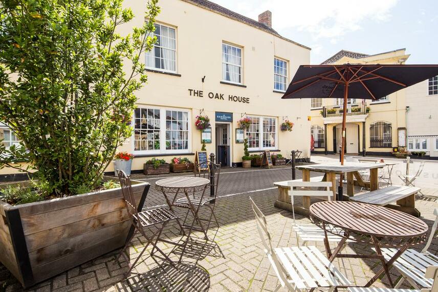
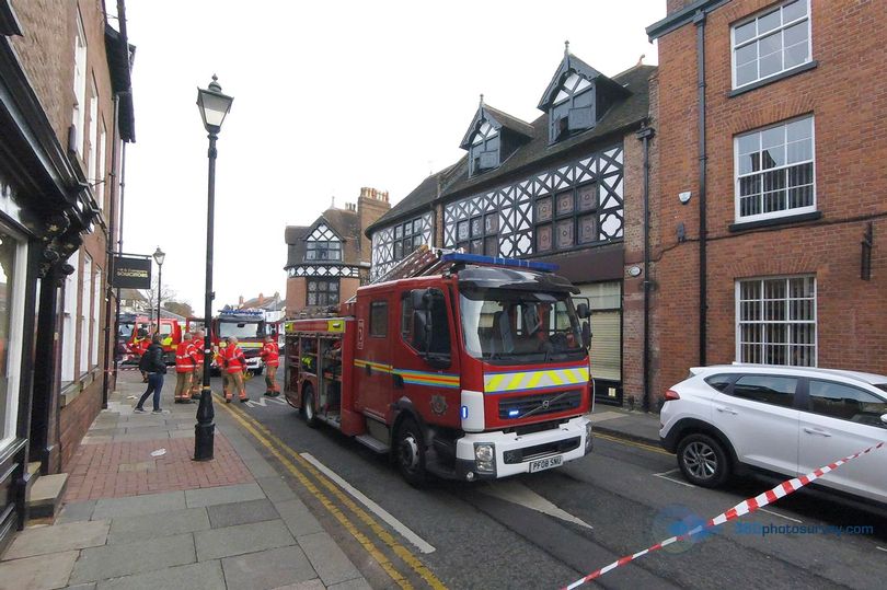
23 February 2019 (01:30) - Crews called after unattended candle starts early morning fire at Somerset hotel
Fire crews were called to an incident at a Somerset hotel in the early hours of this morning (23rd) after an unattended candle ignited a picture frame and artificial flowers. Engines from Cheddar and Burnham-on-Sea were sent to The Oak House Hotel in Axbridge at around 1:30am after receiving a call from someone within the property. Upon arrival crews found that most of the fire had already been put out by a passer-by who, when he heard the alarm, entered the hotel and used an extinguisher. The remaining fire, located in the bar area, was quickly dealt with by crews. The cause of the fire was accidental, a spokesperson for Devon & Somerset Fire & Rescue Service confirmed.
The Oakhouse hotel is a Grade II listed late 18th century building that sits in the medieval market square in the town of Axbridge. Parts of the hotel date back to the 11th century and original features include an ancient well and a large inglenook fireplace. It was originally two separate houses. It lies within the Axbridge Conservation Area.
News Source: Somerset Live
Market Street, in the town centre, was sealed off in both directions while crews attended (Image: 360photosurvey.com)
Listing Details
|
Entry Name: The Oak Hotel and Restaurant
Listing Date: 29 January 1985 Grade: II Source: Historic England Source ID: 1344862 English Heritage Legacy ID: 268696 Location: Axbridge, Sedgemoor, Somerset, BS26 County: Somerset District: Sedgemoor Civil Parish: Axbridge Built-Up Area: Axbridge Traditional County: Somerset Lieutenancy Area (Ceremonial County): Somerset |
Coordinates
Latitude: 51.2874 / 51°17'14"N Longitude: -2.8167 / 2°49'0"W OS Eastings: 343139 OS Northings: 154563 OS Grid: ST431545 Mapcode National: GBR JF.Z26C Mapcode Global: VH7CV.4W8Z |
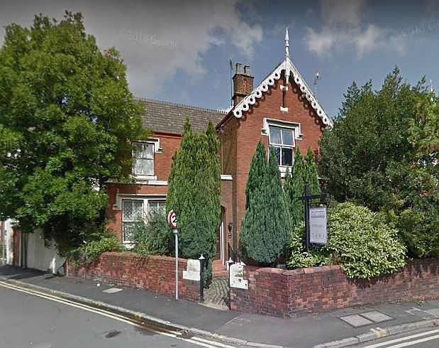
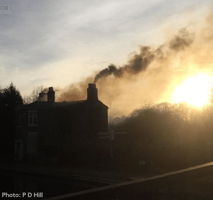
22 February 2019 (16:13) - Fire crews tackle blaze in historic Lock Keeper’s House
Four fire crews from West Midlands Fire Service faced a difficult task yesterday (Friday 22nd February) as a fire tore through an historic Grade II listed landmark canalside building in Kings Norton.
The Junction House, built around 1802, sits on the Worcester and Birmingham Canal, between Lifford Lane and Wharf Road and is inaccessible by road. Crews from Kings Norton, Woodgate, Bournbrook and Ladywood attended the call to a fire in the vacant tollhouse building. Crews from Erdington and Smethwick also attended at changeover. A spokesman for West Midlands Fire and Rescue Service confirmed officers were despatched following reports of a blaze in the early 19th-century building. He said: “We were called to Wharf Road, Kings Norton , following reports of a fire in a disused toll house on the canal at around 4.13pm on Friday, February 22.”
A response vehicle was able to get to the scene but fire trucks were unable to get close, meaning 20 firefighters had to carry equipment to the location and pump water from the canal to tackle the blaze. Firefighters wearing breathing apparatus searched the building as there was concern rough sleepers may have been using the property. Two crews remained on scene overnight as a precaution but the scene was cleared by the fire service this morning. It is understood that the building is owned by the Canal and River Trust and they have been contacted for comment. West Midlands Police confirmed that they are investigating the incident as arson.
News Source: B31 Voices
Listing Details
|
Entry Name: Canal House at Junction of Worcester and Birmingham Canal with the Stratford on Avon Canal
Listing Date: 8 July 1982 Grade: II Source: Historic England Source ID: 1291474 English Heritage Legacy ID: 217364 Location: Birmingham, B30 County: Birmingham Electoral Ward/Division: Kings Norton Built-Up Area: Birmingham Traditional County: Worcestershire Lieutenancy Area (Ceremonial County): West Midlands Church of England Parish: Kings Norton Church of England Diocese: Birmingham |
Coordinates
Latitude: 52.4121 / 52°24'43"N Longitude: -1.923 / 1°55'22"W OS Eastings: 405332 OS Northings: 279351 OS Grid: SP053793 Mapcode National: GBR 3GH.LNP Mapcode Global: VH9Z8.MM7Q |
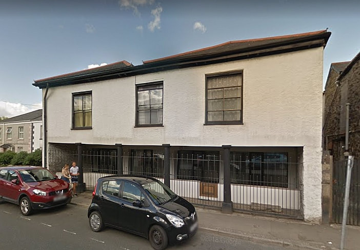
22 February 2019 (09:30) - Fire crews tackle blaze at flat above a shop in Altrincham
Firefighters tackled a blaze at a flat above a shop in Altrincham. Market Street, in the town centre, was sealed off in both directions while crews attended. Firefighters were called to reports of the blaze at 9.30am this morning. They used four breathing apparatus and two hose reels to bring it under control. It was extinguished at around 11.15am, but crews remained at the scene to carry out clean up operations. A spokesman for the fire service said there were no reports of any injuries.
The fire was in a building that covers 1, 1a and 3 Market Street and 2 Post Office Street and it is Grade II listed. The whole of Market Street lies within the Old Market Place Conservation Area. It was originally built as Morrison's Central Auction Galleries, in the 1890's for Sir William Cunliffe Brooks.
News Source: Manchester Evening News
Market Street, in the town centre, was sealed off in both directions while crews attended (Image: 360photosurvey.com)
Listing Details
|
Entry Name: 1, 1a and 3 Market Street and 2 Post Office Street
Listing Date: 12 July 1985 Last Amended: 24 January 1986 Grade: II Source: Historic England Source ID: 1323744 English Heritage Legacy ID: 212770 Location: Trafford, WA14 County: Trafford Electoral Ward/Division: Altrincham Parish: Non Civil Parish Built-Up Area: Altrincham Traditional County: Cheshire Lieutenancy Area (Ceremonial County): Greater Manchester Church of England Parish: Altrincham St George Church of England Diocese: Chester |
Coordinates
Latitude: 53.3884 / 53°23'18"N Longitude: -2.3509 / 2°21'3"W OS Eastings: 376761 OS Northings: 388012 OS Grid: SJ767880 Mapcode National: GBR DY08.V1 Mapcode Global: WH98V.V3Q5 |
22 February 2019 (03:19) - Bread Street takeaway gutted by fire
e Motorists have been facing disruption this morning after a fire broke out at a takeaway in Edinburgh’s Old Town more than six hours ago. About 40 firefighters have been involved in battling the blaze at the Ramen and Rice takeaway in Bread Street, after being alerted just before 3:20am.
At its height, six fire engines and a height appliance were used to tackle the flames but this has now been scaled back to two engines. A fires service spokeswoman said that firefighters are now checking for any remaining hotspots. No one has been hurt as a result of the fire, the cause of which is unknown at this stage. Equipment from the restaurant was brought out onto the street by firefighters. At around 7am, the fire had been largely extinguished and crews were working to dampen down the building.
The building lies within the West End Conservation Area and within the Edinburgh World Heritage Site. It is part of a row of terraced buildings that are Category C listed as a group. They were designed by William Burn, circa 1820, for the Merchant Company's Grindlay Estate.
News Source: Edinburgh Evening News
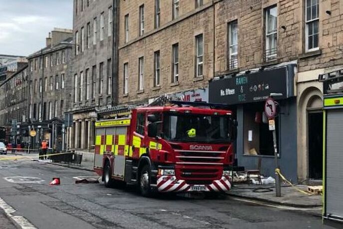
The scene outside the takeaway. (Picture: Shell Bryson)
Listing Details
|
Entry Name: 7-33 (Odd Nos) Bread Street
Listing Date: 29 March 2001 Category: C Source: Historic Scotland Source ID: 366135 Historic Scotland Designation Reference: LB28345 Building Class: Cultural Location: Edinburgh County: Edinburgh Electoral Ward: City Centre Traditional County: Midlothian |
Coordinates
Latitude: 55.946 / 55°56'45"N Longitude: -3.2049 / 3°12'17"W OS Eastings: 324846 OS Northings: 673204 OS Grid: NT248732 Mapcode National: GBR 8LJ.90 Mapcode Global: WH6SL.RT13 |
21 February 2019 (20:12) - Firefighters tackle chimney fire in Cerne Abbas
Crews of firefighters were called to a thatched cottage in Acreman Street, Cerne Abbas following reports of a chimney fire. Dorset and Wiltshire Fire and Rescue Service was alerted to the incident at 8.12pm yesterday, (21st). Crews from Dorchester, Maiden Newton, Yeovil and an Aerial appliance from Yeovil were sent to the scene.
A fire service spokesman said: “The first attending appliance arrived quickly on scene and confirmed that the fire was confined to the chimney. Crews extinguished the fire using a hose reel jet and equipment from the appliance chimney kit.”
The cottage lies within the Cerne Abbas, Charminster, Sydling St Nicholas & Godmanstone Conservation Area and considered as an Important Local Building - a small number of individually attractive and interesting unlisted buildings, most of which contribute to the value of larger groups. The Conservation Area Appraisal describes the row of cottages, where the chimney fire happened in the following way:
“Several older houses and cottages on Acreman Street: 10-18, a row of rendered and flint and brick cottages opposite Francombe Farmhouse, one rendered with sashes and its neighbour with a thatch roof with a noticeable ramping down on the eaves and then several rendered cottages, one with a reset medieval head and a 1858 plaque.”
News Source: Dorset Echo
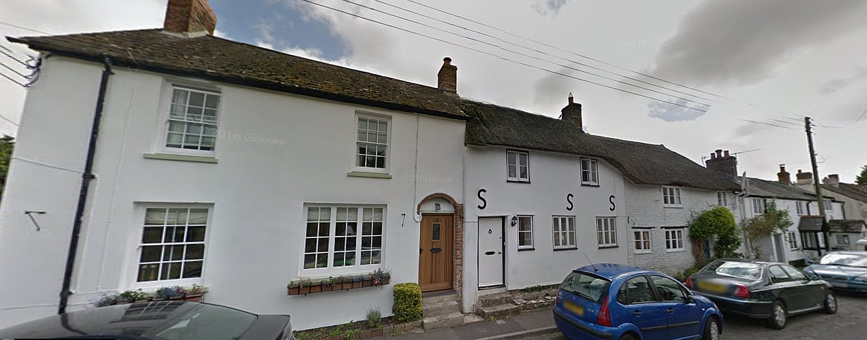
The row of cottages where the chimney fire happened (Credit: Google Maps)
19 February 2019 (12:35) Fire tears through first-floor flat in Cornwall
A fire that tore through a flat in mid Cornwall scrambled crews from St Austell, Lostwithiel and Truro. The blaze broke out on the first floor at St Blazey on Tuesday lunchtime, and spread to the roof. It happened on Fore Street and Pirate FM understands everyone made it out of the building safely. Crews, wearing breathing kit, used hoses and jets managed to stop the flames from spreading further.
A statement from Cornwall Fire and Rescue Service said: “Two pumps from St Austell community fire station, one pump from Lostwithiel, the Aerial Ladder Platform from Truro and two Wholetime officers were mobilised to a fire in a first floor flat and roof space in St Blazey. Crews used six sets of breathing apparatus, two thermal image cameras, two hosereels, one safety jet and one covering jet to extinguish the fire and prevent further spread. There is currently a Fire Investigation Team on route to confirm the source of the fire". Posting on Facebook, St Austell Community Fire Station later confirmed the cause was accidental.
The fire was in the building known as “The Old Market House” which is Grade II listed and build in 1840-50, extended in 1881 (datestone). It has now been converted to flats.
News Source: Pirate FM

Listing Details
|
Entry Name: The Old Market House
Listing Date: 11 March 1974 Grade: II Source: Historic England Source ID: 1289702 English Heritage Legacy ID: 396609 Location: St. Blaise, Cornwall, PL24 County: Cornwall Civil Parish: St. Blaise Built-Up Area: St Blazey Traditional County: Cornwall Lieutenancy Area (Ceremonial County): Cornwall Church of England Parish: St Blazey Church of England Diocese: Truro |
Coordinates
Latitude: 50.362 / 50°21'43"N Longitude: -4.7162 / 4°42'58"W OS Eastings: 206904 OS Northings: 54867 OS Grid: SX069548 Mapcode National: GBR N3.VDD1 Mapcode Global: FRA 1802.NG6 |
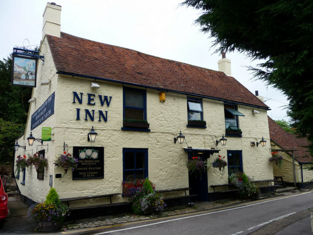
19 February 2019 (10:50) - Chimney fire at the New Inn in Shalfleet
A small chimney fire has been tackled at The New Inn in Shalfleet today (Tuesday). Newport’s wholetime appliance was mobilised to the village at just before 11:00 this morning following reports of a chimney fire. The crew promptly arrived on scene and used a variety of specialist tools to fully extinguish the fire. Firefighters were on scene for almost 2 hours as a full inspection of the pub’s loft was carried out to ensure the fire had not spread. They left the scene at 12:49.
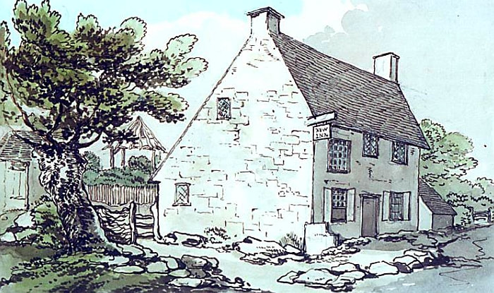
The Inn is a Grade II listed building and started life as a "church house" belonging to the nearby church. In 1734 much of the building was destroyed by fire and was rebuilt as a "new" inn. A lease of 1744 still survives by which John Perkins of Wellow agreed to erect at his own expense on the site of the old church house "a house with walls of brick or stone, of 2 storeys high, the ground storey to be eight foot high and the other storey seven foot to-the plate".
Kelly's Directory records that in 1881 the landlady was a widow from Southampton called Emma Shotter who shared the pub with her children Clement and Selina. For a time, beer for the pub was brewed in the big stone house opposite known as The Maltsters. Parts of the original "church house" can still be seen in the public bar.
News Source: Island Echo
Listing Details
|
Entry Name: New Inn
Listing Date: 28 March 1994 Grade: II Source: Historic England Source ID: 1219658 English Heritage Legacy ID: 393142 Location: Shalfleet, Isle of Wight, PO30 County: Isle of Wight Civil Parish: Shalfleet Built-Up Area: Shalfleet Traditional County: Hampshire Lieutenancy Area (Ceremonial County): Isle of Wight Church of England Parish: Shalfleet St Michael the Archangel Church of England Diocese: Portsmouth |
Coordinates
Latitude: 50.7017 / 50°42'6"N Longitude: -1.4149 / 1°24'53"W OS Eastings: 441415 OS Northings: 89284 OS Grid: SZ414892 Mapcode National: GBR 78V.WN5 Mapcode Global: FRA 77X7.4L5 |
Near Miss
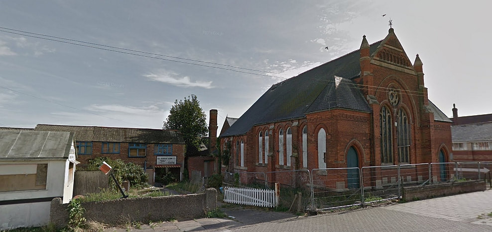
18 February 2019 (19:28) - Investigations continue after two more fires in Skegness
18 February 2019 (19:28) - Investigations continue after two more fires in Skegness
Investigations are continuing after a second fire in two days at a derelict builder's yard in Skegness, next to the former Victorian Church. - and another just an hour later on an industrial estate in the town.- Lincolnshire Fire and Rescue this morning reported 'a busy night on the East Coast' after crews from Skegness and Wainfleet were scrambled to the blaze on Roman Bank - and then called to another derelict building on Heath Road.
Roads on Roman Bank were again closed after emergency services received the call at 7.28pm and crews used one hose reel jet and two breathing apparatus, small tools and two thermal imaging camera to extinguish the blaze. Crews from Skegness, Alford and Wainfleet were called to Heath Road at 8.33pm. They used one hose reel and two breathing apparatus to extinguish the fire at the second derelict building.. Earlier in the day, police confirmed that Sunday's fire at the yard on Roman Bank was 'deliberate'
One resident Barry Robinson said: "This is two nights running that there has been a fire here. There's a derelict church on the corner of Roman Bank. It's shocking that it's happening so often. There are rumours flying around about what is happening."
News Source: Skegness Standard

18 February 2019 (16:10) - Fire at Windsor's Duchess of Cambridge pub
Firefighters raced to the Duchess of Cambridge pub in Thames Street, Windsor at 4.10pm this afternoon after receiving reports of a fire. Royal Berkshire Fire and Rescue (RBFRS) crews from Windsor, Ascot, two crews from Slough and the Aerial Ladder Platform (ALP) from Whitley Wood Fire Station were sent to the scene, which is right in the shadow of Windsor Castle.
They found a fire in the chimney of the building and the road was closed while they tackled it. The road has been closed off. But a staff member said that the fire had been contained and it was hoped the premises could open as usual tonight. The Chimney that was involved in the fire lies almost between the pub and the Grade II listed Lloyds Bank next door.
The Duchess of Cambridge pub is Grade II listed and dates from the 17th century, with alterations in the 19th century. Its listing describes it as part of an important group of consecutive listed buildings on the road. The pub has had several names. It was The Grapes Public House in the 1910s and 1920s. When it was listed in 1975, it was the Knights Tavern. It was Bar & Kitchen until 2011, when, following refurbishment it became the Duchess of Cambridge on the 21st June 2011.
News Source: Windsor Observer
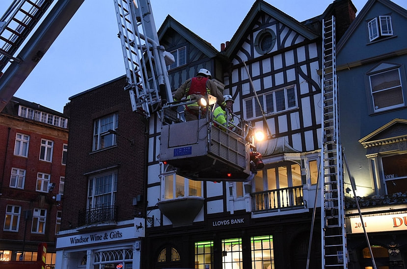
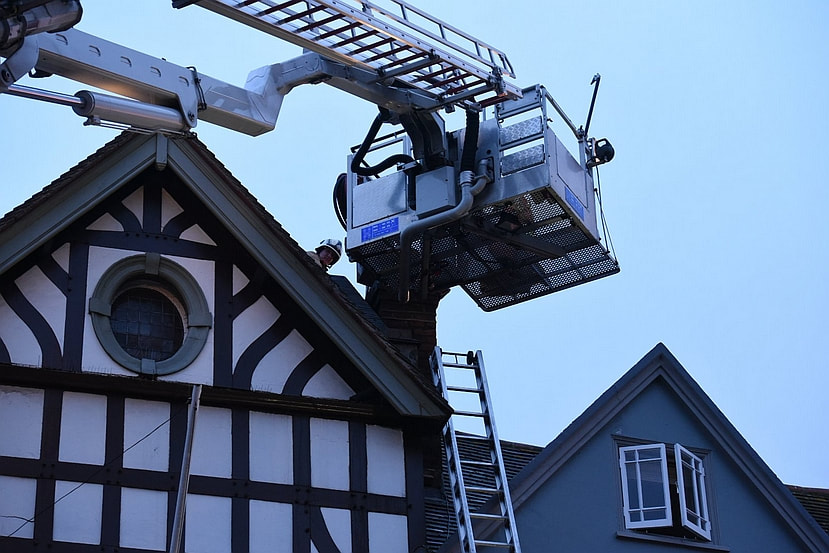
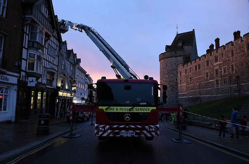
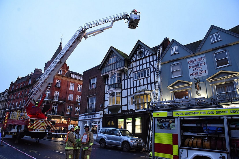
Firefighters at the Duchess of Cambridge Pub, Windsor (Photos: Ian Longthorne / Windsor and Slough Express)
Listing Details
|
Entry Name: Knights Tavern
Listing Date: 2 October 1975 Last Amended: 29 October 1975 Grade: II Source: Historic England Source ID: 1319310 English Heritage Legacy ID: 40557 Location: Windsor and Maidenhead, SL4 County: Windsor and Maidenhead Electoral Ward/Division: Castle Without Built-Up Area: Windsor Traditional County: Berkshire Lieutenancy Area (Ceremonial County): Berkshire Church of England Parish: New Windsor Church of England Diocese: Oxford |
Coordinates
Latitude: 51.4831 / 51°28'59"N Longitude: -0.6084 / 0°36'30"W OS Eastings: 496726 OS Northings: 176936 OS Grid: SU967769 Mapcode National: GBR F8D.WJJ Mapcode Global: VHFT8.DZQF |
Near Miss
17 February 2019 (19:19) - Fire at derelict building on Roman Bank in Skegness
17 February 2019 (19:19) - Fire at derelict building on Roman Bank in Skegness
Police have confirmed that the fire at a derelict builder's yard in Skegness was 'deliberate' Fifty per cent of the ground floor area of the building on Roman Bank and its contents were destroyed in the blaze, which was reported to Lincolnshire Fire and Rescue at 7:19pm last night (Sunday). Today, police issued the following statement: "At 7.26pm on February 17 we received a report of a fire at premises in Roman Bank. We believe this was a deliberate act.."
Four fire crews from Skegness, Wainfleet, Boston and Spilsby were scrambled to the scene next to the former Primative Methoidist Chapel. Roads around the blaze were closed and residents asked to close their windows and doors and stay away from area. The fire was extinguished using two hose reel jets, two main jets, an aerial ladder platform from Boston and thermal imaging cameras. There were no injuries. Police are appealing for witnesses. Anyone who may have seen someone acting suspiciously in the area at around 7.25pm can contact police on 101, quoting incident number 324 of Feb 17.
The former Victorian chapel, standing just a few metres away from the building set on fire, was built in 1899. It replaced an older chapel across the road, which was subsequently converted to three houses. It closed as a Chapel in 1979, and since then has been used as a second hand furniture store (see Building History below).
News Source: Skegness Standard


The proximity of the derelict building, where the fire started, to the former Chapel
Building History
(Researched by Heritage & Ecclesiastical Fire Protection)
The “Skegness Herald” of April 14th, 1899 reports: “The new and commodious Chapel and School which has been erected on the Roman Bank, were opened on Thursday afternoon, April 13th, by Mrs. E. Handsley, of London. The proceedings commenced at 2 p.m. when a procession formed, at the east end of Lumley Road, proceeded to the buildings. The Rev. F. J. Morgan presented to Mrs. Handsley the gold key with which she unlocked the door and then declared the building “Opened for Worship.” A large congregation assembled for the opening service. The opening hymn was: ‘Behold Thy Temple, God of Grace – The House that we have reared for Thee.’ and after prayer was offered by the resident Baptist Minister (Rev. G. Goodchild), a sermon was preached by the Rev. John Smith, President of the Conference.”
Seven years later the present organ was installed, the opening being fixed for May 13th, 1906. Shortly after this the Skegness Circuit was formed, with the Roman Bank Church as its head.
November 22nd, 1923, will be remembered as the day on which the Foundation Stones were laid for the Church Parlour. This additional building was opened on Thursday, February 27th, 1924. The “Skegness News” dated March 5th, 1924, reports: “Thursday last was a red-letter day in the annals of Skegness Primitive Methodism. In the afternoon, Mrs. Pattinson, the wife of the Member of Parliament for the Horncastle Division opened the new Church Parlour, and after a sermon by the Rev. J. P. Hill, of Sutton- on – Sea, in the Chapel, Capt. Jessap, M.B.E., in a sympathetic and moving address, unveiled the Memorial to the nine members of the congregation who gave their lives in the Great War. A well attended tea followed, and in the evening a Public Meeting was held in the Chapel, presided over by Sir Thos. Robinson, J.P., and addressed by the Rev. J. P. Hill, Mr. C. K. Watkinson and others.”
With the coming of Methodist Union in September,, 1932, the local Primitive Methodists proudly took their stand with other sections of Methodism, that there might be formed the great Methodist Church. Circuit Amalgamations followed in 1933, when the ex-Wesleyan Skegness and Wainfleet Circuit, the ex-Primitive Methodist Skegness Circuit, and the ex-Primitive Methodist Leake circuit joined hands to form the present Skegness and Wainfleet Methodist Circuit, the Roman Bank Church occupying second place on the Circuit Plan.
The year 1979 saw a far-reaching change for Methodism in Skegness. As a result of Roman Bank's financial difficulties, as well as the recommendations of the District Redevelopment Committee, it was decided that Roman Bank and Algitha Road Methodist Churches should amalgamate and should use the latter church's premises. On Sunday morning 23rd September 1979 the actual union of the two congregations and Sunday Schools took place. There was first a united service at Roman Bank, conducted by the Chairman of the District the Rev. W. Eric Jones and then all joined in a procession to Algitha Road where a Communion service was held.
Following its closure as a chapel in 1979, it became a second hand goods store called ‘Ye Old Church’. It later became "Old Church Home Furnishings" which closed sometime between 2009 and 2014. The building has been vacant since then.
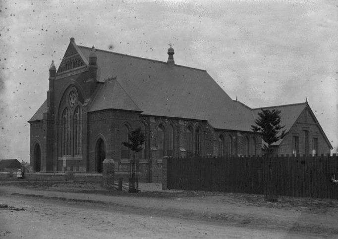
Roman Bank Primitive Methodist Chapel in 1900, soon after it was built.
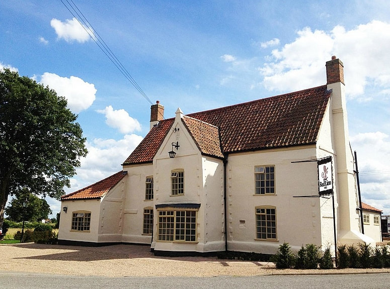
15 February 2019 (11:10) - Electrical fault leads to pub fire in Bicker
A fire has caused extensive damage to the popular 17th century Grade II listed Ye Olde Red Lion pub in Bicker today. Crews from Donington, Billingborough and Boston were called to the pub, in Donington Road, Bicker, just before 11.10am. Two water hose reels, four thermal imaging cameras, six extinguishers and a fan were used to tackle the fire and clear smoke. However, the incident damaged a utility area and its contents, floorboards in a bathroom and left smoke damage to the whole building. A statement posted by pub managers on social media said: "Due to an electrical fault and fire, we are having to close this weekend. The emergency services have been fantastic and the main thing is that no one was injured. However, the damage to the background floor is a little worse than we thought."
News Source: Spalding Today
News Source: Spalding Today

Listing Details
|
Entry Name: The Red Lion Inn
Listing Date: 26 January 1967 Grade: II Source: Historic England Source ID: 1062015 English Heritage Legacy ID: 192072 Location: Bicker, Boston, Lincolnshire, PE20 County: Lincolnshire District: Boston Civil Parish: Bicker Built-Up Area: Bicker Traditional County: Lincolnshire Lieutenancy Area (Ceremonial County): Lincolnshire Church of England Parish: Bicker St Swithin Church of England Diocese: Lincoln |
Coordinates
Latitude: 52.9202 / 52°55'12"N Longitude: -0.1772 / 0°10'37"W OS Eastings: 522648 OS Northings: 337419 OS Grid: TF226374 Mapcode National: GBR HVJ.XPG Mapcode Global: WHHLV.7VWP |
Building History
(Researched by Heritage & Ecclesiastical Fire Protection)
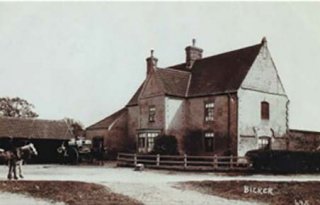
This white-painted inn had the name “John Drury” around the year 1665 (the date of the Great Plague of London) and it is understood that this was the date it was restored, and therefore existed some time before this. Inside, the rooms recapture the atmosphere of a typical English inn, with low beams and paintings of blood sport around the walls. Local tradition says that the pub was once called “ Mariner’s Rest”, and the “Sailors Rest”. The local belief that Bicker Haven was once an inlet of the Wash, and that the Red Lion was once a lighthouse, has no known historical basis other than its position beside the river, by then already reduced to a trickle.
(Researched by Heritage & Ecclesiastical Fire Protection)
This white-painted inn had the name “John Drury” around the year 1665 (the date of the Great Plague of London) and it is understood that this was the date it was restored, and therefore existed some time before this. Inside, the rooms recapture the atmosphere of a typical English inn, with low beams and paintings of blood sport around the walls. Local tradition says that the pub was once called “ Mariner’s Rest”, and the “Sailors Rest”. The local belief that Bicker Haven was once an inlet of the Wash, and that the Red Lion was once a lighthouse, has no known historical basis other than its position beside the river, by then already reduced to a trickle.

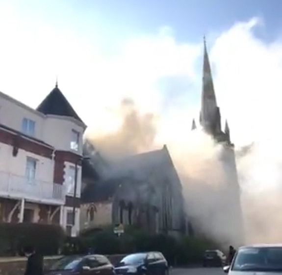
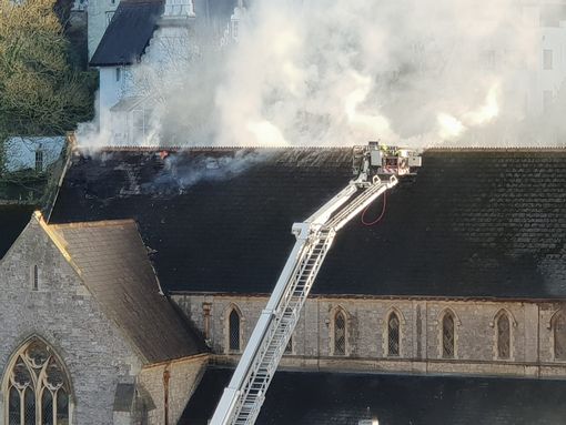
14 February 2019 (14:00) - Fire crews to battle blaze into the night at Rainbow Fun House Church
More than 40 firefighters are currently on the scene in Torquay after a fire broke out at an abandoned church - and they are expected to be there through the night. Devon and Somerset Fire Service received 20 calls from members of the public following reports of the fire which started at 2pm. A total of seven fire engines from Newton Abbot, Paignton, Teignmouth and Newton Abbot along with a command support vehicle from Totnes and an aerial ladder platform from Danes Castle are currently fighting a large fire involving the derelict building locally known as Rainbow Fun House building. It is currently unknown whether any people are inside the building but the fire is involving the first floor and the roof space. Residents nearby are also being advised to stay indoors and to keep their windows shut.
Group Commander for South Devon, Matt Johnson who is currently on the scene said: “One of the problems is that the building is full of old play equipment and that is hampering us very much. We are likely to be here for some time, we still have seven fire engines here and the aerial ladder carrying out extensive searches in the building. The roof space has two layers of wooden boarding under the tiles.”
At the moment fire crews on the aerial platform are ripping off tiles off the roof to expose the wooden boards beneath. Station manager Nick Bankes-Fay added: “We are ripping the tiles off but the wooden boarding is aiding the fire. We have breathing apparatus crews in there and we believe the fire started on the first floor, there are concerns about people who have been inside the building but we are not overly concerned.”
Constructed in 1894 by J Watson, as the Church of the Holy Trinity and is a Grade II listed building. It was built on the site of an earlier chapel. The gate piers and wall is also separately Grade II listed. The stained glass of the West window is by Drake & Son, designed by Maurice Drake, and completed in 1907. It is notable for its corner pinnacles with flying buttresses.
It had been owned by Alan Wood since 1982. It was formerly the Breakaway Sports Centre and Sports Club and he developed it into the Rainbow Fun House, a children’s soft play area, which opened in February 2001. In 2010, The Fun House failed to sell at auction on the retirement of Mr. Wood with a guide price of £600,000. It finally closed in 2015 and went to auction again but this time with a guide price of £215,000. Since then, the building has been boarded up. In 2017, a group moved into the former church and said that they hoped to claim squatters rights to create a community space. But they were evicted and the property became further boarded up and fenced off.
News Source: Devon Live
Listing Details
|
Entry Name: Breakaway Sports Centre breakaway Sports Club
Listing Date: 10 January 1975 Last Amended: 3 May 1994 Grade: II Source: Historic England Source ID: 1206804 English Heritage Legacy ID: 390694 Location: Torbay, TQ1 County: Torbay Electoral Ward/Division: Wellswood Built-Up Area: Torquay Traditional County: Devon Lieutenancy Area (Ceremonial County): Devon Church of England Parish: Torquay St Matthias Church of England Diocese: Exeter |
Coordinates
Latitude: 50.461 / 50°27'39"N Longitude: -3.5207 / 3°31'14"W OS Eastings: 292158 OS Northings: 63451 OS Grid: SX921634 Mapcode National: GBR QX.3F16 Mapcode Global: FRA 37JT.S90 |
13 February 2019 (19:40) - Fire breaks out at Northampton Museum
A fire has broken out in a museum that is currently closed for refurbishment. Emergency services were called to Northampton Museum and Art Gallery after smoke was seen coming from the property, in Guildhall Road, at 19:40 GMT. Fire crews forced their way into the building to tackle the second-floor blaze, which it said "involved debris and had travelled through the floor". Northampton Fire & Rescue Service is advising motorists to avoid the area due to road closures. Residents are also being told to keep windows and doors closed. The museum closed in February 2017 for a "major new expansion project". It is hoped work will be completed by spring 2020.
Update 14 February 2019 - Northampton Borough Council said this morning that the authority still needs to carry out a full assessment but damage looks relatively minor at this stage. Northampton Borough Council leader, councillor Jonathan Nunn, said: “We're extremely grateful to Northamptonshire Fire and Rescue for their quick response, and to whoever called the incident in to the Fire Control Room.” The local authority is also awaiting the result of the fire investigation regarding cause and have said more updates will be offered as they become available.The fire was on the fourth floor in the north-west corner of the Georgian "Old Gaol Block". It is not understood to be an area that will be accessible to the public once the renovations of the complex are complete. The museum and the Old Gaol Block both lie within the Derngate Conservation Area.
News Source: BBC News
The first phase of the £6.7m museum refurbishment project is being funded entirely through proceeds generated from the controversial sale of the 4,000 year old Sekhemka statue, which was sold to a private collector for £16m in 2014. The project will add an extension into the former Georgian Gaol Block on Angel Street, which was initially part of the museum until being sold off and became a Salvation Army barracks with mineral water factory in the basement. The council has now bought back the Old Gaol building. The reclaimed space will house a shoe gallery to showcase the museum’s collection. The location of the gallery allows it to flow into parts of the vaulted structures which formed the original Gaol, more than doubling the amount of public space.
The council has appointed contractor Wildgoose Construction Limited for the expansion, which will include new galleries, a cafe and educational spaces. The new shoe gallery will highlight Northampton's links with the industry and featuring items including Prince Albert's boots and Queen Victoria's wedding shoes. Despite the complexity and issues presented by three historic buildings and joining these together with a new-build element, Wildgoose has confirmed it can deliver the whole project within budget by spring 2020.
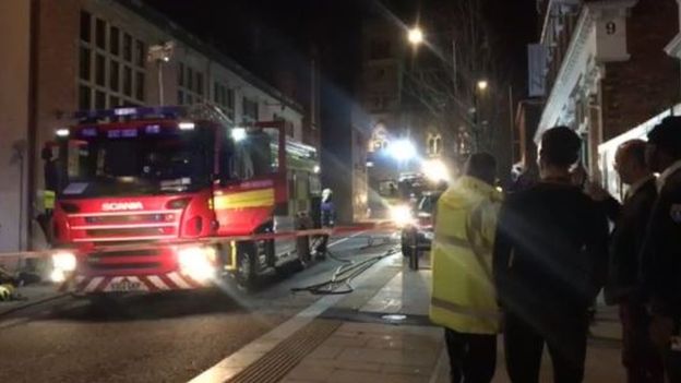


Building History
(Researched by Heritage & Ecclesiastical Fire Protection)
The Museum is housed in part of a Georgian gaol complex. After the Great Fire of Northampton in 1675 in which the early gaol burnt down, a new gaol, House of Correction and the Sessions House were built on the site of the town’s old gaol. The gaol during this time was of poor condition, as reflected in the prison reformer’s report in 1689. In 1691 the County purchased the house adjoining county hall on the west side and two other pieces of land. In 1791, the Georgian Gaol Block known as the Old County Gaol was built on Guildhall Road by Bruttingham along the lines recommended by the prison reformer John Howard, which included:
“Every prison be white-washed at least once every year, and that this be done twice in prisons which are much crowded.
That a pump and plentiful supply of water be provided, and that every part of the prison be kept as clean as possible.
That every prison be supplied with a warm and cold bath, or commodious bathing tubs, and that the prisoners be indulged in the use of such baths, with a proper allowance of soap and the use of towels.
That attention be paid to the sewers in order to render them as little offensive as possible.
That great care be taken, that as perfect a separation as possible be made of the following classes of prisoners.
That felons be kept entirely separate from debtors; men from women’ old offenders from young beginners; convicts from those who have not yet been tried.
That all prisoners, except debtors be clothed on their admission with a prison uniform and that their own clothes be returned to them when they are brought to trial or are dismissed.
That care be taken that the prisoners are properly supplied with food, and their allowance not deficient, either in weight or quality.”
The gaol had room for 120 prisoners. The 17th century gaol was converted into a turnkey’s lodge with a day-room for debtors on the ground floor and a grand-Jury room on the first floor. The current museum building is part of a gaol block that was opened in 1846 with capacity for 150 inmates. It comprised two galleried wings with single-occupant cells arranged along the walls at four floors. Legislative changes rendered the gaol redundant and the east wing was converted for use as a library, public reading room and a museum.
The Old Gaol, Northampton
13 February 2019 (16:00) - Fire crews called to Manningham's Lister Mill
A fire in a light fitting caused a flat in Manningham's Lister Mill to be filled with smoke this afternoon. Fire crews had to break into the unoccupied apartment at 4pm after the alarm was set off by smoke from the overheating light fitting. Firefighters wearing breathing apparatus made sure the fire was extinguished after breaking into the home in the Silk Mill part of the complex. The flat and surrounding corridor was then vented to clear the smoke. Crews from Fairweather Green and Shipley attended the incident.
The vast Listers Mills complex is Grade II* listed. Built in 1871, it was converted into flats in 2006 (see Building History below).
News Source: Telegraph and Argus
The vast Listers Mills complex is Grade II* listed. Built in 1871, it was converted into flats in 2006 (see Building History below).
News Source: Telegraph and Argus
Listers Mill now converted to flats with modern "Pods" on the roof
Listing Details
|
Entry Name: Manningham Mills
Listing Date: 14 June 1963 Last Amended: 9 August 1983 Grade: II* Source: Historic England Source ID: 1314426 English Heritage Legacy ID: 336556 Location: Bradford, BD9 County: Bradford Electoral Ward/Division: Toller Parish: Non Civil Parish Built-Up Area: Bradford Traditional County: Yorkshire Lieutenancy Area (Ceremonial County): West Yorkshire Church of England Parish: Manningham St Paul and St Jude Church of England Diocese: Leeds |
Coordinates
Latitude: 53.8086 / 53°48'30"N Longitude: -1.7784 / 1°46'42"W OS Eastings: 414692 OS Northings: 434722 OS Grid: SE146347 Mapcode National: GBR JCD.Q9 Mapcode Global: WHC98.NJCM |
Building History
(Researched by Heritage & Ecclesiastical Fire Protection)
If you had to describe the Listers Mills complex in Manningham in one word, it would be ‘monumental’! Lister's Mill (otherwise known as Manningham Mills), was founded in 1838 by Samuel Cunliffe Lister, The business eventually made Lister one of Bradford's most famous fathers, a multi-millionaire and the provider of thousands of jobs in the city. Lister's Mill changed the identity of the region, its skyline and its economy. Lister himself epitomised Victorian enterprise; and he worked on a grand scale.
Disaster struck in 1871 when a fire destroyed much of the earlier mill and claimed the lives of two workers. Undeterred, Lister had a new mill complex rise phoenix-like from the ashes. When the new Manningham Mills opened, they were the largest and most imposing textile building in the north of England. Two vast multi-storey blocks dominate the site, one a spinning mill and the other used mainly as a warehouse. An imposing boundary wall creates a fortress of industry.
They remain a dominant feature of the skyline, even today. Designed by local architects in an Italianate style and with a chimney reaching 249 feet into the air, inspired by the design of St Mark’s Campanile in Venice, the new buildings covered a vast area of 13 acres. The new mills were a fitting home for the Lister empire, which by 1871 had acquired several other mills in the north of England and a colliery (Manningham Mills alone used 50,000 tons of coal per year!).
On its completion in November, 1873, the Bradford Observer reported of the chimney:
“Shortly before twelve o’clock, Mr Lister accompanied by Captain Lepper [the mill manager] the architects, Messrs Andrews and Pepper, and Mr William Beanland, the builder, ascended. The summit having been reached, the baptismal right was performed by Mr Lister breaking a bottle of wine and naming the column ‘The Lister’s Pride’. The party then partook of a champagne luncheon.”
At its height, Lister's was the largest silk spinning and weaving mill in Great Britain and employed over 11,000 people. It was a major exporter, with two thirds of all its production going overseas.
Lister built the largest silk factory in Europe and was the most important textile inventor of his time. Although he was known as the 'King of Velvet', his business was diverse, and over the many years it traded, produced an enormous range of fabrics. Crepes and chiffons were produced for ladies' fashions; military uniform and parachute fabrics were made during the wars and synthetic fabrics such as Crimplene and Terylene were manufactured. As early as 1889, Lister had become world famous for the production of silks, imitation sealskin and mohair plush, although he was probably best known for his velvets. The company supplied more than 1,000 yards to Westminster Abbey for the Coronation of George V in 1911, and as late as 1976 supplied the velvet for the curtains in the White House in Washington. During WW2 Listers produced 1,330 miles (2,140 km) of real parachute silk, 284 miles (457 km) of flame-proof wool, 50 miles (80 km) of khaki battledress and 4,430 miles (7,130 km) of parachute cord.
After decades of decline in the post-war period Lister and Company went into administration in 1997. Lister Mills fell into dereliction and were included on the first Buildings at Risk Register in 1998. Urban Splash, a development company with a track record of converting iconic buildings to new uses, took on the site in 2004. After extensive repairs, two multi-storey blocks are no longer at risk and they now house over 300 apartments as well as commercial and community uses. The addition of bold roof-level pods show how creative interventions can open exciting new chapters for historic buildings. The next stage of regeneration includes urgent repairs to parts of the perimeter wall, which Historic England hopes to support with funding.
12 February 2019 (20:00*) - Fire crews and ambulance called to the Maritime Inn at the Barbican.
Emergency services have rushed to the Barbican in Plymouth following reports of a fire. The fire service and paramedics have been seen outside the Grade II listed Maritime Inn on Southside Street. An eyewitness said they saw crews arrive on scene just after 8pm.
A member of staff at the early 19th century Maritime Inn has confirmed that a woman has been taken to hospital after a fire broke out in the flat above the pub. Elizabeth Ely, a member of bar staff at the pub, said: “There was an accident in the kitchen of the flat which is upstairs. I believe it involved chips being left to cook for too long. My boss has been taken to hospital but she’s OK - it’s just a precaution. They are checking for smoke inhalation. I think the kitchen is quite badly damaged. Fire crews have now left and the pub continues to be open as usual.”
The Maritime Inn lies within the Barbican Conservation Area.
News Source: Plymouth Live
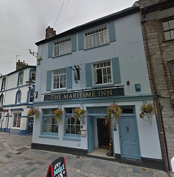
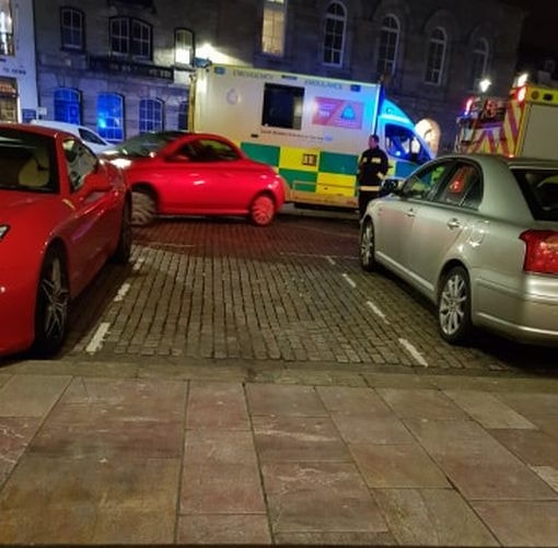
Listing Details
|
Entry Name: Bulwick Stores and Post Office
Listing Date: 31 March 1988 Grade: II Source: Historic England Source ID: 1371970 English Heritage Legacy ID: 232886 Location: Bulwick, East Northamptonshire, Northamptonshire, NN17 County: Northamptonshire District: East Northamptonshire Civil Parish: Bulwick Traditional County: Northamptonshire Lieutenancy Area (Ceremonial County): Northamptonshire Church of England Parish: Bulwick and Blatherwycke St Nicholas Church of England Diocese: Peterborough |
Coordinates
Latitude: 52.537 / 52°32'13"N Longitude: -0.5816 / 0°34'53"W OS Eastings: 496298 OS Northings: 294185 OS Grid: SP962941 Mapcode National: GBR DVN.XDG Mapcode Global: VHFN7.VHWG |
12 February 2019 (18:30) - Award-winning East Northants village shop goes up in flames
Fire crews from across the county were battling to save a much-loved village shop tonight after it caught fire tonight. Firefighters were called to The Bulwick Village Shop, home to The Pickled Village, at about 6.30pm tonight after flames were spotted.
At the height of the blaze, 30 firefighters from Northamptonshire and Lincolnshire were on the scene tackling the fire in the Grade II listed thatched building, which dates back to the 17th century and lies within the Bulwick Conservation Area. Neighbours in Main Street have been told to keep windows and doors closed and several homes were evacuated. Fire crews are expecting to be on the scene throughout the night. A cordon is in operation in Main Street. The owner of the shop posted her thanks on the shop’s Facebook page tonight and said: “Thank you all for your support. We’re all safe and sound. X”
The shop was founded in 2005 by Camille Ortega McLean who took on the former post office and renovated it. Now, a huge range of home-made and locally-produced food and drink is sold from the shop which attracts custom from across the county and beyond. It has also won many awards. Prospective Parliamentary Candidate for Corby and East Northants Beth Miller also passed on her well wishes to the shop and said she was thinking of the owners.
News Source: Northamptonshire Telegraph
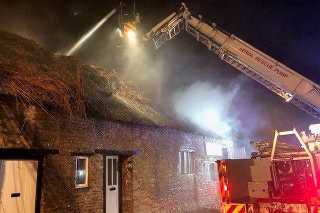
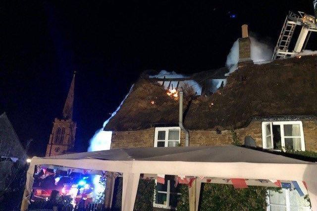
Listing Details
|
Entry Name: Bulwick Stores and Post Office
Listing Date: 31 March 1988 Grade: II Source: Historic England Source ID: 1371970 English Heritage Legacy ID: 232886 Location: Bulwick, East Northamptonshire, Northamptonshire, NN17 County: Northamptonshire District: East Northamptonshire Civil Parish: Bulwick Traditional County: Northamptonshire Lieutenancy Area (Ceremonial County): Northamptonshire Church of England Parish: Bulwick and Blatherwycke St Nicholas Church of England Diocese: Peterborough |
Coordinates
Latitude: 52.537 / 52°32'13"N Longitude: -0.5816 / 0°34'53"W OS Eastings: 496298 OS Northings: 294185 OS Grid: SP962941 Mapcode National: GBR DVN.XDG Mapcode Global: VHFN7.VHWG |
12 February 2019 (17:45) - Flat fire breaks out in Ryde
Firefighters are tackling a flat fire on Union Street in Ryde this evening (Tuesday). One appliance is currently on scene with firefighters commited to the property above iFix Local. Residents have been evacuated and the area cordoned off. Other appliances are struggling to reach the scene due to a number of vehicles stuck in the one-way system. Union Street is currently closed to all traffic. The alarm was raised at 5.45pm, and by 7.25pm the fire in the kitchen had been successfully extinguished and crews had left the scene. No one has been injured as a result of the fire.
The building is Grade II listed and was built in about 1840. This part of Ryde has a very high density of listed buildings and lies within the Ryde Conservation Area.
Source: Island Echo
The building is Grade II listed and was built in about 1840. This part of Ryde has a very high density of listed buildings and lies within the Ryde Conservation Area.
Source: Island Echo
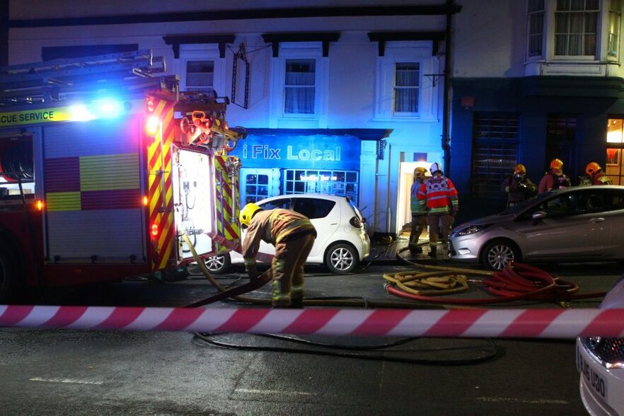
The fire was in a flat above iFix Local in Union Street, Ryde
Listing Details
|
Entry Name: 30 and 31, Union Street
Listing Date: 18 May 1972 Grade: II Source: Historic England Source ID: 1238993 English Heritage Legacy ID: 416697 Location: Ryde, Isle of Wight, PO33 County: Isle of Wight Civil Parish: Ryde Built-Up Area: Ryde Traditional County: Hampshire Lieutenancy Area (Ceremonial County): Isle of Wight Church of England Parish: Ryde Church of England Diocese: Portsmouth |
Coordinates
Latitude: 50.7306 / 50°43'50"N Longitude: -1.162 / 1°9'43"W OS Eastings: 459235 OS Northings: 92669 OS Grid: SZ592926 Mapcode National: GBR 9CN.11Q Mapcode Global: FRA 87G4.T9D |
12 February 2019 (14:58) - Eleanor Street building in Grimsby on fire AGAIN
A building on Grimsby's Eleanor Street is on fire again this afternoon. Humberside Fire and Rescue crews are battling the blaze at the constantly targeted buildings. At least four crews from Humberside Fire and Rescue's green watch are currently battling the blaze.The former education offices, which are due to be converted into flats and shops in the future, along with neighbouring buildings, is a regular target for arsonists.
The group of late Victorian and Edwardian buildings, which lie in the Holme Hill Conservation Area - The College of Art and Design (Grade II listed), built as the Wintringham Higher Grade School in 1894, School Board Offices, (Grade II listed), built in 1900-01, and Farnhurst, a private house built in 1893, (the home of Thomas W J Allen (surgeon) in 1909 and Locally listed), later a care home - are some of the most dilapidated in Grimsby.
A Humberside Fire and Rescue service spokeswoman said a call was received at 2.58pm and crews arrived at 3.06pm. Humberside Police have also been called to help direct traffic around the busy road while the incident is dealt with. Eleanor Street is closed between Hainton Avenue and Heneage Road. A cordon has been put in place as there are fears the fire may spread throughout the building.
Station Manager Richard Gibson said: “We received reports of a fire at an abandoned building on Eleanor Street. We mobilised four appliances to the scene along with an aerial appliance. Upon arrival we found a well developed fire at the building, which was quickly brought under control. We will be investigating the cause of the fire and are well aware about the problems with this building. We have pre-planned for these events and were well prepared to tackle this blaze.”
Eleanor Street is now the town's number one arson hotspot. There have been at least 42 deliberate attacks on the historic buildings in the past five years, with at least 14 fire call outs during 2018. Official statistics, uncovered as part of the Stop the Rot campaign, show how expensive security and monitoring by emergency services failed to deter a quadrupling in arson call outs since 2013. A bystander said: “This happens all the time, why is nothing being done about this building.” Passers-by are also discussing the history of the building at the corner, wondering when it was shut down as they learned to swim there. Another passerby said that people have been accessing the building through a hole in the fence at the rear of Boyes car park. The site is said to be full of fly-tipped rubbish.
Back in October 2018, a war of words broke out as the battle to save the historic Eleanor Street complex intensified. The company hoping to salvage the rotting Education Offices and Art College said it had now exhausted all options to save them. East Marsh Regeneration (EMR) blamed council delays and the authority's perceived lack of support for the perilous dereliction of the buildings. But North East Lincolnshire Council hit back - warning the company that the authority could use legal powers to protect the buildings.
EMR submitted a 90-apartment redevelopment plan to the council's planning department 12 months ago. Eight months later, and planners were still to give their verdict, leaving the company in limbo and the historic complex on the verge of complete dilapidation. Consultant Gareth Gerner confirmed the plan, which would see a large section of the buildings demolished, is now stalled until the council makes a decision or helps to unlock grant funding for an alternative proposal. He said: "We believe we have done everything in our power to stop this situation, but until the council grants permission or agrees a solution to bridge the market gap, there is no more we can do. So we continue to make proposals to the council and wait on the council officers to accept one of these proposals or come up with alternatives, to ensure that this much needed community scheme is delivered together."
There have also been objections from Historic England to the plans which have caused delays, so EMR is working to find a proposal that saves more of the buildings. But Mr Gerner said the financial context is "very challenging" and the private sector alone cannot make it viable in the current market. A North East Lincolnshire Council spokeswoman said funding sources are available to potentially bridge the viability gap. But she said EMR had provided insufficient detail in its business case and the company would need to take the lead in securing any funding. Issuing a warning to the firm, she said: "It is important to note that as owners of the buildings, the company have a legal responsibility to stop the buildings falling into a dangerous condition. Should they fail to do so; the council could be required to exercise its legal powers."
So, whilst N.E. Lincolnshire Council, EMR and Historic England argue over who is to blame, the buildings have reached a critical stage and are falling into a dangerous condition. Decades of neglect since their closures in the 1990s, have caused a massive downturn from their glory days and these once proud buildings are now fenced off with signs warning of danger. Soon they will have been damaged beyond economical repair and there will be no option but to demolish them. The Grimsby College of Art and Design, and the next door School Board Offices, have been included on the Victorian Society’s list of the ten most endangered Victorian and Edwardian buildings in England and Wales.
News Source: Grimsby Live
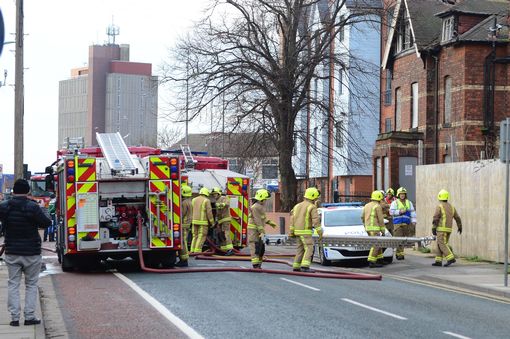
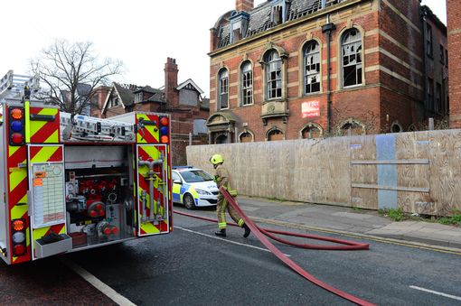
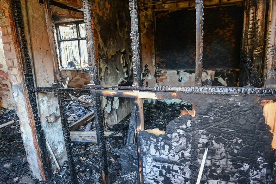
The inside of the former art college has been destroyed by repeated fires (Image: Jon Corken/Grimsby Live)
Listing Details
|
Entry Name: Education Department Offices
Listing Date: 30 June 1999 Grade: II Source: Historic England Source ID: 1379833 English Heritage Legacy ID: 479266 Location: North East Lincolnshire, DN32 County: North East Lincolnshire Electoral Ward/Division: East Marsh Built-Up Area: Grimsby Traditional County: Lincolnshire Lieutenancy Area (Ceremonial County): Lincolnshire Church of England Parish: Great Grimsby St Andrew with St Luke and All Saints Church of England Diocese: Lincoln |
Coordinates
Latitude: 53.5674 / 53°34'2"N Longitude: -0.0735 / 0°4'24"W OS Eastings: 527683 OS Northings: 409587 OS Grid: TA276095 Mapcode National: GBR WWX5.WX Mapcode Global: WHHHS.VL6K |
A 1920s postcard showing the three buildings in their glory days.
Near Miss
10 February 2019 (21:44) - Man suffers burns to head and dog dies in Kinnerton house fire
10 February 2019 (21:44) - Man suffers burns to head and dog dies in Kinnerton house fire
A man was taken to hospital and a dog has died following a house blaze in Lower Kinnerton, Chester. Emergency teams are investigating the cause of the blaze, which happened at a semi-detached home on Kinnerton Road just before 9.45pm on Sunday, February 10. Three fire engines – one from Chester, one from Powey Lane and one from North Wales Fire and Rescue Service – were called to the blaze. On arrival, all persons were accounted for and the semi-detached house was heavily smoke logged, with smoke coming out of the windows. A man had suffered burns to his head as a result of the fire. He was treated by paramedics and taken to hospital via an ambulance. The man had tried to go back into the house before firefighters arrived as his dog was in there. Unfortunately, the man and firefighters were unable to save the dog, who died in the fire.
An eyewitness, who asked not to be named, said she heard the sirens and could see smoke coming from the building next to Moor End Farm in Lower Kinnerton. She said she saw one fire engine, an ambulance and several police cars at the property and heard the dog had died in the fire. The house's gas and electricity supply were isolated and six firefighters wearing breathing apparatus entered the property. They used two hose reel jets to extinguish the fire. A safety jet was also put in place. The fire was contained in the living room of the house. Once the fire was out, firefighters used a thermal imaging camera to check for hotspots and a large fan to clear smoke from the house. Firefighters were in attendance for around three hours and 40 minutes.
The fire was at Kinnerton Court, a converted historic barn that was associated with Moor End Farm, a 19th century farmhouse. Near to both the farmhouse and Kinnerton Court is a Grade II listed shippon and cart house, now known as Kinnerton Grange (see map)
News Source: The Standard
Listing Details
|
Entry Name: Former Central Farm Building Associated with Moor End Farm
Listing Date: 2 November 1983 Grade: II Source: Historic England Source ID: 1138383 English Heritage Legacy ID: 55340 Location: Dodleston, Cheshire West and Chester, CH4 County: Cheshire West and Chester Civil Parish: Dodleston Traditional County: Cheshire Lieutenancy Area (Ceremonial County): Cheshire Church of England Parish: Dodleston St Mary Church of England Diocese: Chester |
Coordinates
Latitude: 53.151 / 53°9'3"N Longitude: -2.9709 / 2°58'15"W OS Eastings: 335168 OS Northings: 361982 OS Grid: SJ351619 Mapcode National: GBR 76.5JVY Mapcode Global: WH88L.B2J6 |
10 February 2019 (21:30) - Co Tyrone derelict building fire was started deliberately, say police
A fire at a derelict building in Co Tyrone was started deliberately, police have said. The blaze happened at around 9.30pm on Sunday at a building in the Derry Road area of Strabane. PSNI sergeant James McLaughlin appealed for anyone who witnessed the fire to come forward. "Police attended along with NIFRS who extinguished the blaze, the fire service has advised that this fire was started deliberately," he said. "I am appealing to anyone who was in the area around this time, or prior to when the fire was reported to us and has information that they believe could assist our investigation to call non-emergency 101, quoting reference 1249 10/02/19."
The building on the Derry Road has been derelict for some years, and Cllr Patsy Kelly says there have been persistent problems with people going into the site. At times, he says, it has been the focus of anti-social behaviour. Cllr Kelly says this will intensify local efforts to have the site secured
Local MLA, Daniel McCrossan says the arson attack is a waste of emergency services time and says it’s time to look at the future use of the building. “The fire at Smyth's Mill has done nothing but endanger lives and waste valuable public resources. Our local emergency services are doing a terrific job under intolerable pressures. The last thing they need is to be responding to deliberate arson attacks which are preventable. The Smyth Mill is an historic site located in the town. It has been used by a number of youths recently who have broken and entered the premise. [It] needs to be urgently secured and we must look at ways to utilise the building in future. The building is centrally located within the town. It is in private possession but we must look at how it can be used. This fire could have been much worse given the businesses located located next to it. I thank the emergency services for their rapid response and for extinguishing the fire.”
Robert Smyths & Sons, Animal Feed Millers was founded at Canal Basin Mills, Strabane in 1865 by Robert Smyth from Cookstown, Co. Tyrone. Initially Smyths Mill produced 'Cookquick' Porridge Oats and animal feed. From the 1920s the mill concentrated on producing animal feed compounds up until its closure in 1980. At the start of the 20th century, Smyth's Mill’s grain shipments accounted for half the canal's freight.
News Source: Belfast Telegraph Digital
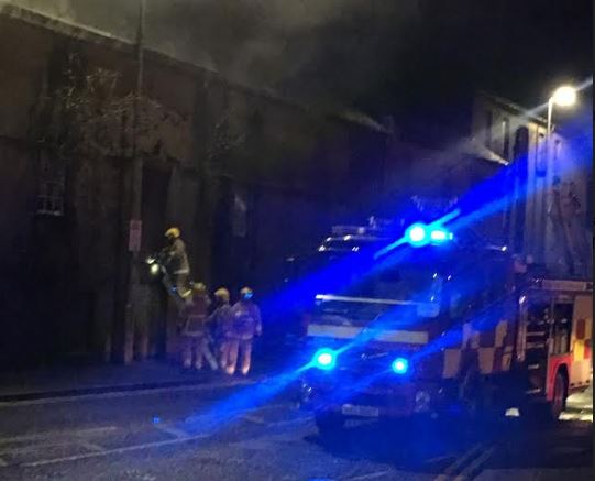
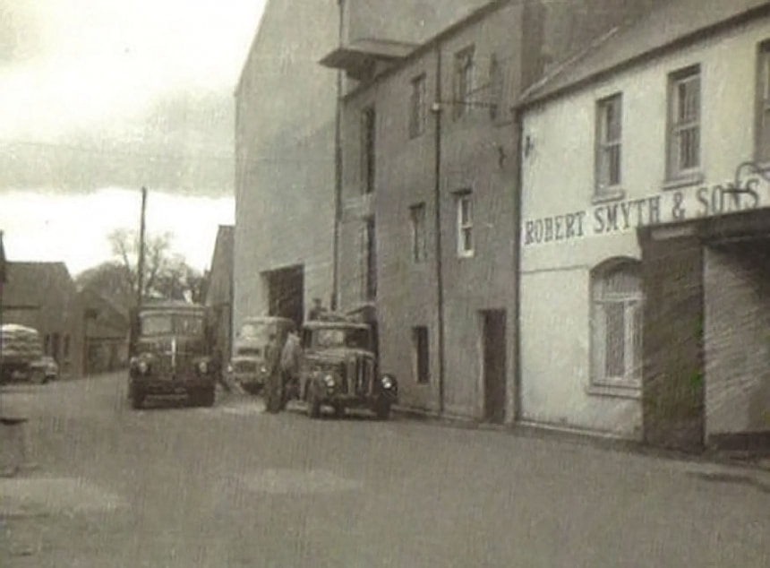
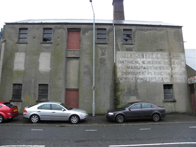
10 February 2019 (16:24) - Building fire at RAF Upwood, Huntingdonshire
On Sunday (10th) at 4.24pm, one crew from Huntingdon and the north roaming fire engine were called to a fire in a derelict building at RAF Upwood. Firefighters used dry powder to extinguish the fire, before returning to their stations by 5.10pm. The cause of the fire is believed to be deliberate. Anyone with information should contact police by visiting www.cambs.police.uk to submit an online report. It is the latest in a long history of arson attacks at the historic former RAF and USAFE site, which has been targeted on dozens of occasions in recent years.
Councillor Robin Howe, who represents Upwood and the Raveleys, said “The buildings should have been preserved instead of being desecrated and we as a council should have secured the site and kept it in good condition, but unfortunately once the gate was left open for years the vandalism has occurred.”
There have been six failed planning applications to develop the site after it was included in the area's Local Development Plan in 2013, proposing the allocation of the former RAF base for development for a mix of uses including housing. A comment from Debbie Mack of Historic England, in response to this said, “Although this site contains no designated heritage assets, the heritage value of this RAF station should be carefully considered and opportunities taken to identify and where appropriate preserve non-designated heritage assets. We therefore welcome the requirement that development assesses the buildings and reaches agreement with the council over which to retain or demolish. This requirement is undermined by the first paragraph of the development guidance, which states that there are few buildings of sufficient architectural merit. This appears to prejudice the outcome of any building assessment and should be reworded.”
Strawsons, which owns the former base have been trying to get permission to build housing on the site since the late '80s, but concerns over traffic and drainage have blocked changes. In the meantime, vandals have been using the abandoned site as a playground. In May 2017, the owners of the base said they were expecting to receive planning permission for 160 homes, saying that Huntingdonshire District Council has accepted "housing must go somewhere". Huntingdonshire District Council confirmed that subject to some last minute matters being dealt with it expected planning permission to be issued shortly, however, nearly two years later and no work has started on site.
News Source: Cambridgeshire F&RS
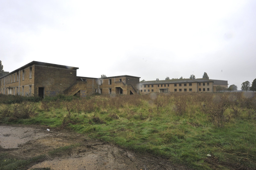
Building History
(Researched by Heritage & Ecclesiastical Fire Protection)
RAF Upwood is a historic former Royal Air Force station adjacent to the village of Upwood, Cambridgeshire. It was built more than 100 years ago when The Royal Flying Corps requisitioned 160 acres of farmland near the village of Upwood in 1917 . It was a non-flying station which was under the control of the United States Air Force from 1981, and one of three RAF stations in Cambridgeshire used by the United States Air Force in Europe (USAFE). Upwood, along with RAF Molesworth and RAF Alconbury are considered the "Tri-Base Area" due to their close geographic proximity, and interdependency.
Since 1982, the Nene Valley Gliding Club has conducted its glider operations from a field that occupies the site of the old runways. Initially these operations were under an agreement with the Ministry of Defence. However, in 1995 the club was told they would need to find a new home as the land was going to be sold off. The club was unable to locate a suitable new home and was preparing for the possibility of having to close when the purchaser of the land, Marshal Papworth, agreed to lease the land to the club for 10 years. This has allowed the club to continue flying from Marshals Paddock (so named by the club after their benefactor's death in 2000). Much of the RAF Upwood is unused, closed by the MOD in 1994. Most of the station was vacated and the land and buildings sold off to civil ownership.
Upwood is also the home of No. 511 (Ramsey) Squadron Air Training Corps who have been on the site since the early 70s. Originally housed in the old fire station the squadron moved to a number of buildings before settling in the old nissen hut church building. When the station was closed by the MOD in 1995, the squadron moved to the Upwood school. The squadron finally settled into the present building inside the fence in 1997. In 2004 Turbine Motor Works purchased a large amount of property on the former base including the four C-type hangars.
Every year in August the site is home to the Ramsey 1940s Weekend, an event dedicated to recreating the sights and sounds of the 1940s. The event is held in aid of several local charities and has been rewarded with a tourism award. The weekend features living history re-enactors, period dancing, food, exhibitions and trade stands. This has now moved to the north-west side of Ramsey to "The Camp", a former searchlight base. The American medical wing has been disused since early 2013.
RAF UPWOOD SUMMER 1946
The School Flight are L to R :-
Back Row - Barrie Kendall, Peter Steggles, Les. Steggles, Bill Collard, Denis Tomkins and ? Peacock.
Centre - Eddie Venables, ? Edge
Seated - Dick Langford (Flt Sgt), Peter Belsey (Sgt.)
Front -Jack(?) Davidson
9 February 2019 (10:00) - Firefighters scale thatched roof to tackle serious blaze
Approximately 55 firefighters are at the scene of a thatched roof fire in Rougham, near Bury St Edmunds. Firefighters were called shortly before 10am this morning with reports of a major blaze at a property in Nether Street, Rougham. About 11 crews from Suffolk Fire and Rescue Service are currently at the scene, including two specialist vehicles also in attendance – including a multi star from Bury St Edmunds and a water bowser from Newmarket. Ian Bowell, response commander, confirmed that the roof of the property was well alight.
A spokeswoman for the fire service said the extent of the damage is unclear as the incident is ongoing. The occupants are believed to have been evacuated from the property and there are no reports of any injuries. Suffolk police have also been called to the scene to assist with traffic management. A spokeswoman for the force said there are not thought to be any suspicious circumstances linked to the blaze. Suffolk Fire and Rescue Service are urging people to avoid the area to allow the crews to work safely.
The house, known as “Oakwood”, was formerly divided into two cottages. It is Grade II listed and dates back to the 17th Century.
Source: EADT
Update: A couple have said they are “really grateful” to firefighters for working tirelessly to salvage their possessions following a blaze at their thatched home in west Suffolk. William Hardy, 34, was inside the house in High Rougham with his young son when passersby alerted him to the fire in the thatched roof today at about 10am. The fire service sent eight appliances, along with the Multistar from Bury St Edmunds, a water bowser from Newmarket and support vehicles, to the detached house, which is owned by the Rougham Estate. Group commander Ian Mallet said when the first crew arrived it was “a rapidly escalating job” due to the windy conditions, which led to all the thatch being on fire. They battled the blaze and removed the thatch, while also retrieving as many of the occupants’ belongings as possible.
Mr Hardy’s partner Emily Dixon, 37, was out at the time of the blaze, as was her 10-year-old daughter, and rushed home as soon as she heard the distressing news. Miss Dixon, a special teaching assistant at the Priory School in Bury St Edmunds, said she was “lost for words” to describe the efforts of the firefighters, but added it was “amazing” they were able to save some of their things. “It’s not our house, we rent it, but it’s our home and we obviously love it. It’s surreal standing here,” she said. What was particularly upsetting for her was the loss of special items of her daughter’s from when she was a baby, which they will “never get back”. Mr Hardy also praised the fire service, telling how they went inside to retrieve a cuddly bunny for his three-year-old son. “We are really grateful, and for those people who came by as well. I don’t know really what would have happened if they hadn’t gone past,” he said. The family, who had no contents insurance at the property, are able to stay with relatives.
George Agnew, of the Rougham Estate, which owns about 60 properties, said his main concern was everybody was okay. Mr Agnew, who came to the scene on learning of the fire, said: “We look after all the properties, and take particularly the historic ones very seriously. Our intention is to restore this place and, if at all possible, to re-thatch.”
Mr Mallet said it was “testing conditions” for the firefighters, adding the wind was driving the fire through the thatch. “A large proportion of the occupants’ contents have been salvaged,” he said. “We will be determining the conclusion on the completion of the incident.” A full fire investigation will be taking place, but the blaze is not believed to be suspicious. The section of the road near the house was closed by the police and power to the street was turned off for a time by EDF Energy. Mr Mallet expected the fire service to be on scene for a “significant” amount of time.
Source: EADT
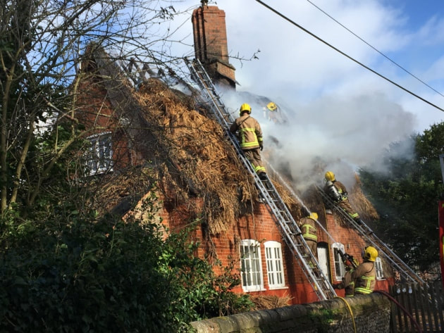
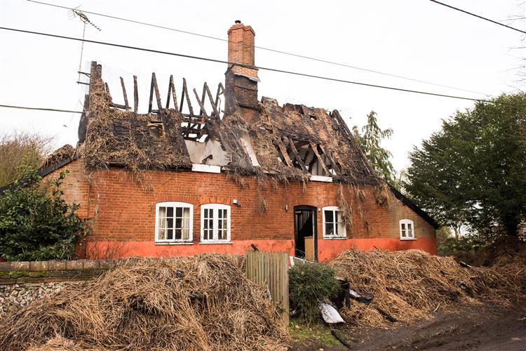
Listing Details
|
Entry Name: Oakwood
Listing Date: 28 March 1985 Grade: II Source: Historic England Source ID: 1031132 English Heritage Legacy ID: 284470 Location: Rushbrooke with Rougham, St. Edmundsbury, Suffolk, IP30 County: Suffolk District: St. Edmundsbury Civil Parish: Rushbrooke with Rougham Traditional County: Suffolk Lieutenancy Area (Ceremonial County): Suffolk Church of England Parish: Rougham St Mary Church of England Diocese: St.Edmundsbury and Ipswich |
Coordinates
Latitude: 52.2233 / 52°13'24"N Longitude: 0.8139 / 0°48'49"E OS Eastings: 592294 OS Northings: 262079 OS Grid: TL922620 Mapcode National: GBR RGN.GLM Mapcode Global: VHKDD.2C3Y |
Near Miss
7 February 2019 (19:50) - Fire crews respond to latest school bin fire
7 February 2019 (19:50) - Fire crews respond to latest school bin fire
Fire crews were called out to a Dunfermline school after yet another bin fire. Vandals set one alight outside St Leonard's Primary School on Thursday night last week. A spokeswoman said: “The Scottish Fire and Rescue Service was alerted at 7.50pm on Thursday, February 7, to reports of a bin fire in Dunfermline. Operations Control mobilised one fire engine to St Leonard's Street where firefighters extinguished the fire involving a wheelie bin. Crews left the scene after ensuring the area was made safe.”
It is the latest in a spate of wheelie bin fires in the Dunfermline and West Fife area. Local councillor Kate Stewart said: "There seems to be a trend happening with young people and wheelie bins not just in this area but around Fife. The concerning bit is they are endangering themselves – they don't know what is in these bins and they could be left marked and hurt."
St Leonard's Primary School was built in 1902. Due to the age of the building the design features are very pleasing architecturally and it is a Category C listed building, together with the Gateways and Boundary Wall, against which the wheelie bin was placed.
News Source: Dunfermline Press
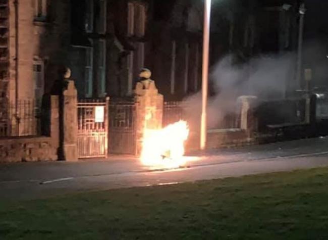
Listing Details
|
Entry Name: St Leonard's Street, St Leonard's Primary School, Including Gateways, Railings and Boundary Wall
Listing Date: 10 March 2000 Category: C Source: Historic Scotland Source ID: 394333 Historic Scotland Designation Reference: LB46949 Building Class: Cultural Location: Dunfermline County: Fife Electoral Ward: Dunfermline Central Traditional County: Fife |
Coordinates
Latitude: 56.0633 / 56°3'48"N Longitude: -3.4508 / 3°27'2"W OS Eastings: 309763 OS Northings: 686559 OS Grid: NT097865 Mapcode National: GBR 1Y.PYJQ Mapcode Global: WH5QR.YVXN |
Near Miss
7 February 2019 (11:30) - North Bradley School evacuated
7 February 2019 (11:30) - North Bradley School evacuated
North Bradley Primary School has been evacuated this morning after what is thought to have been an electrical fire. The school asked parents to pick up their children from the Peace Memorial Hall immediately after the entire school was evacuated at around 11.30am after smoke was seen to be coming from a light fitting. In a post of the Peace Memorial Hall facebook page, a spokesman said: "North Bradley school... urgent. There has been an incident at school but everyone is safe. The school needs to close so could all children be collected from the peace memorial hall asap. They will not have coats bags etc with them as evacuating the school with speed was paramount."
A spokesman from Dorset and Wiltshire Fire said: "One pump from Bradford on Avon was mobilised to a report of a light fitting smoking at a premises in Church Lane, North Bradley. On arrival crews found smoke issuing from electric light fitting. Inspection carried out of roof void. Triple extension ladder, thermal imaging camera and air monitor in use for investigations. Premises advised to contact electrician to inspect property."
Although unlisted, this Historic school building dates back to 1882 (see Building History, below)
Source: Wiltshire Times
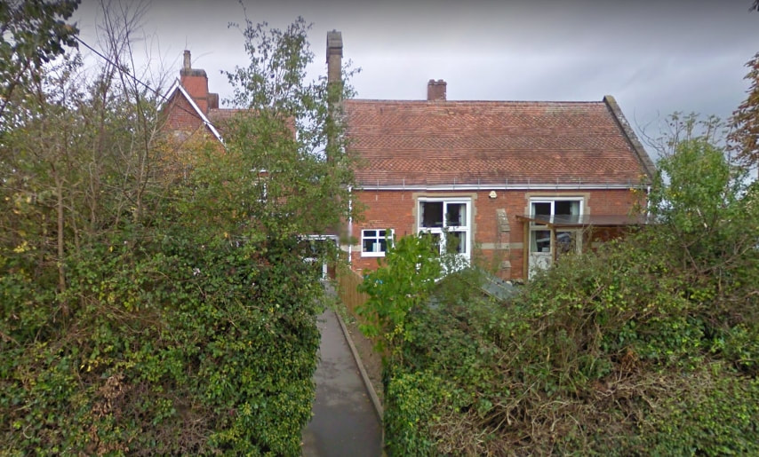
A smoking light fitting caused an evacuation at North Bradley CofE Primary School
Building History
(Researched by Heritage & Ecclesiastical Fire Protection)
The school was originally built by the vicar, Rev. E. A. Weare, on glebe land to prevent the establishment of a non-sectarian Board School. The school succeeded Daubeny's School, which closed when the new school opened. The school, including a head teacher's house of 6 rooms, was designed by Weaver and Adye of Bradford on Avon at a cost of £920. It was partly in brick with Bath stone dressings and partly in Bradford stone. The large schoolroom measured 40 feet by 18 feet and the classroom 20 feet by 16 feet. Both rooms were 13 feet high to the tops of the walls and 17 feet to the apex of the roof. There was accommodation for 100 pupils and the school officially opened on 1st January 1882. The school was in union with the Anglican National Society. In the early 20th century the classroom was lengthened by 6 feet.
Unfortunately the school log books do not begin until 1908, but a picture of Victorian school life in this area can be gained by looking at the web page for Southwick Church of England School. In the first part of the 20th century this was still an elementary school, teaching all ages up to the school leaving age. Apart from the elementary subjects of reading, writing and arithmetic the pupils would have covered history, geography, needlework, music and singing. The boys also had gardening classes and older children went on nature rambles. Some of the teaching was carried out by pupil teachers, who were taught by the head teacher outside school hours, and took exams to obtain teaching qualifications. In December 1909 one of the pupil teachers died of quinsy.
Prior to the First World War the number on the school roll averaged around 115 to 120 although at times, when illnesses were about, there may have only been 60 or 70 children attending school. One of the worst illnesses of this time was diphtheria with many outbreaks occurring. Children who contracted this were often sent to the Isolation Hospital in Trowbridge and on one occasion, in December 1909, only 49 children were able to attend school. At times the school was closed and sometimes it had to be disinfected. These outbreaks overshadowed the more common childhood illnesses, such as chicken pox, measles and mumps.
Annual holidays were very similar to today. There were 2 weeks at Christmas, 2 weeks at Easter and 5 weeks for the summer holiday, with a week at Whitsun. There were also half-day holidays given for various reasons. Regular half-days were given for the annual Fair (4th October) and for the annual parish tea in January, while choir boys were allowed time off to sing at confirmations. In 1911 a special holiday, from 17th - 26th June, was given on the occasion of the coronation of George V. Bad weather also kept children away from school. On March 4th 1909 heavy snowfalls meant that the infants were unable to attend; the school was closed on 18th January when heavy snow made the roads impassable; in February 1917 there were again low attendances owing to heavy snowfalls and an outbreak of colds and influenza. On 10th June 1910 summer storms caused flooding that prevented both staff and children reaching the school while in June 1917 heavy rain made the roads impassable and children from several parts of the village were unable to attend.
The school seemed to have been performing well during this period, as is evidenced from a 1916 Diocesan report. 'I was very well satisfied with my visit to this school. The infants were bright and eager to answer, and they knew their work and said their Repetition nicely. In the older group it was evident that the children had been carefully taught and the answers were good and generally distributed. They sang very well and the written work was above the average'.
In 1931 the school ceased being an elementary school when the older children (aged 11+) were transferred to secondary schools in Trowbridge. North Bradley became a junior mixed and infant school. By 1955 it was a voluntary controlled school.
School buildings and facilities were upgraded in 1986/7 to provide accommodation for 160 children in the late 1980s. It has a large playground, playing field and conservation area, and recently opened a pre-school in part of the building. Children come mainly from North Bradley, with others from Heywood, Hawkeridge and Westbury. In 2002 there were 161 pupils aged from 4 to 11 years.
6 February 2019 (18:30) - ‘Like a war scene’ Five rushed to hospital following HUGE explosion in West Yorks town
Paramedics raced five people to hospital following a huge explosion in Batley, West Yorkshire. Emergency services raced to Hick Lane around 6.30pm on Wednesday. A West Yorkshire Police spokesman confirmed five people had been injured in the suspected gas explosion, but none sustained life-threatening injuries. Nearby residents were evacuated from their homes as a precaution after the blast tore through a two-storey block of converted flats.
A West Yorkshire Fire and Rescue Service said: “Five people have been treated and have now been transported to hospital. The fire is now out, and any remaining pockets of fire are being extinguished should they appear. The incident was initially attended by 10 engines however this is being reduced to five. Firefighters are likely to be on the scene overnight and there are some concerns over the structural stability of the building.”
One witness, who did not want to be named, described the horrific scene, “I’ve never heard anything like it. I came rushing out to find glass everywhere, some even blew 300 yards. Then I saw two men exit the building covered in blood, smoking, obviously very shook. It was like a war scene.” An investigation has been launched into the cause of the explosion.
The Building involved is a Grade II listed former bank and manager’s house, built in 1905.
News Source: Daily Star
Update 5 July 2019: A fire at a block of flats which left six occupants with severe burns was probably started by accident, according to fire investigators. West Yorkshire Fire & Rescue Service has concluded that butane gas from cannisters caused the explosion which tore through the Grade II listed building on Hick Lane, Batley on February 6.
Five months on, a report by the fire service has outlined some details of what happened. The report said: "Butane gas from canisters caused an explosion, causing fire on two floors of the flats with severe blast damage throughout the building and damage to multiple adjacent buildings. Six occupants exited the building with severe burns." The injured six, aged between 35 and 39, suffered severe burns and were treated in hospital. The huge blast blew out windows and left glass and other debris strewn across the road. The fire service report concluded: "The cause of the fire was thought to be accidental." The fire service report does not say why the butane gas canisters were present, nor what caused them to ignite.
Shortly after the incident a local community leader, who did not want to be named, claimed the explosion was linked to a drugs factory at the premises, although this hasn't been confirmed. Two days after the blast West Yorkshire Police confirmed that a large number of small flammable gas cylinders had been found in a flat in the building. The Force said the explosion was not terror-related. Detective Superintendent Pat Twiggs, who is leading the investigation, said at the time that forensic testing would be needed to understand how the cylinders came to ignite and if any criminal offences had been committed. This week a Force spokesman told ExaminerLive that police inquiries into the incident were continuing.
News Source: Examiner Live
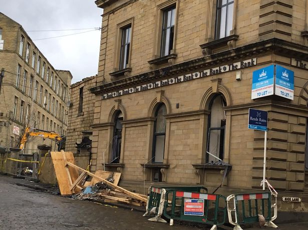
Explosion scene on Hick Lane Batley. The former bank building which was the scene of the explosion.
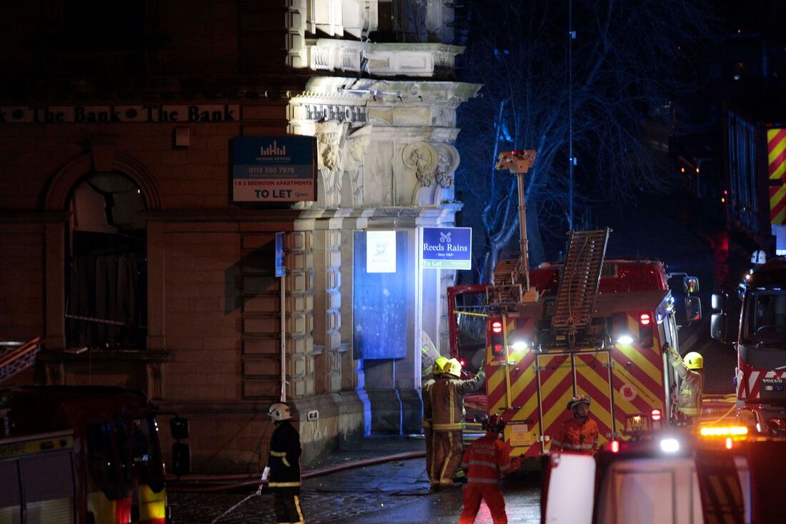
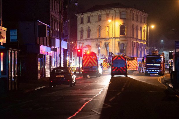
Listing Details
|
Entry Name: The National Westminster Bank
Listing Date: 11 February 1993 Grade: II Source: Historic England Source ID: 1135383 English Heritage Legacy ID: 341114 Location: Kirklees, WF17 County: Kirklees Electoral Ward/Division: Batley East Built-Up Area: Batley Traditional County: Yorkshire Lieutenancy Area (Ceremonial County): West Yorkshire Church of England Parish: Batley St Thomas Church of England Diocese: Leeds |
Coordinates
Latitude: 53.7117 / 53°42'42"N Longitude: -1.6274 / 1°37'38"W OS Eastings: 424690 OS Northings: 423982 OS Grid: SE246239 Mapcode National: GBR KT2J.G6 Mapcode Global: WHC9Q.ZY6Y |
6 February 2019 (00:09) - Huge blaze rips through historic Nelson building
A huge blaze has ripped through a historic former church building in Nelson causing it to partially collapse. The fire at the former Spiritualist Church building next to Unity Hall Wellbeing Centre in Vernon Street started just after midnight today. The blaze was so ferocious that six fire engines from Nelson, Burnley and Colne were at the scene.
County Coun. Zafar Ali, chairman of Nelson Town Council, which owns Unity Hall, described the destruction of the iconic building as a 'sad loss for Nelson'. He said: "We woke up to sad news this morning. The town council was actually speaking to the agent for the building just two weeks ago with a view to buying it and extending our Unity Wellbeing project. Both iconic buildings were built in 1907 and we wanted to preserve this Nelson heritage for the future. Sadly, this no longer looks possible." Coun. Ali has demanded an immediate police investigation into the fire. He said: "It is an absolute tragedy that this historic church has gone up in flames. Pendle Council and the fire service need to act quickly to make sure that what remains of the site is made safe and the police must launch a full investigation into what caused this fire. The Unity Wellbeing Centre has suffered smoke and heat damage and we need to make sure that neighbouring residents are all OK and are not affected by some damage."
Early Suffragist Selina Cooper had helped to lay the foundation stones for the buildings which served as the second assembly hall for the independent Labour party in Nelson at the turn of the last century. The church closed before 2001, as it was being used for storage at that time.
A fire service spokesman said: "Three jets were in use. However the fire quickly spread to the rest of the building which resulted in a partial building collapse. For the safety of the public Vernon Street was closed. The air support unit was deployed to gain better aerial footage of the incident." The roof of the building collapsed around 1am. By 3.25am the incident was scaled back and the water town appliance was in attendance from Blackburn Fire Station. At 6.20am two jets, lighting and breaking in tools were in use. By 7.20am firefighters were damping down and the incident was scaled back to one pump at 8am.
Source: Burnley Express
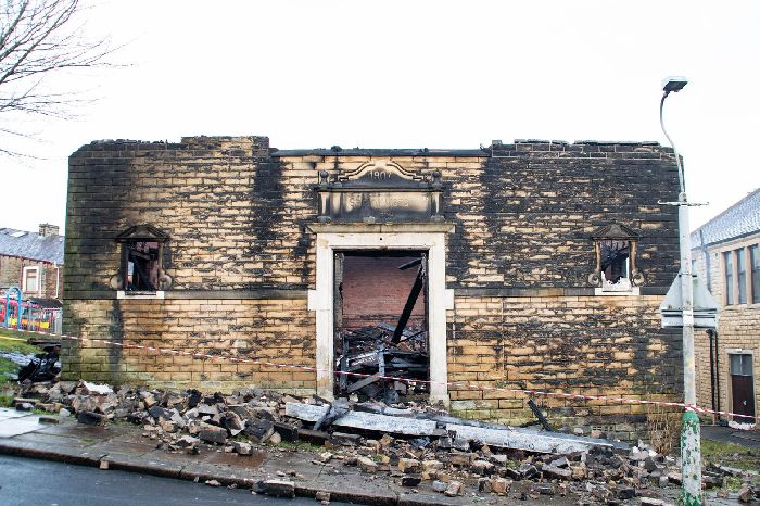
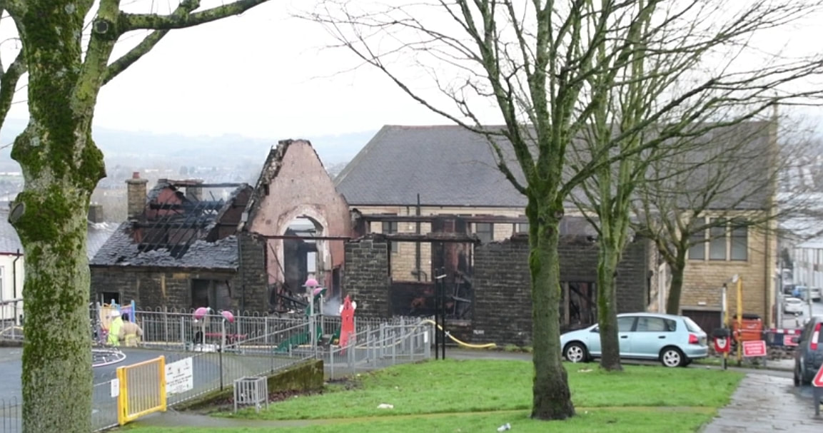
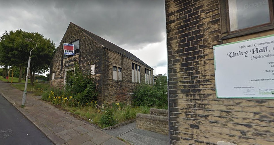
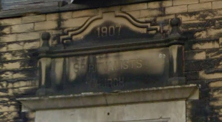
5 February 2019 (20:30) - Slieve Donard Hotel evacuated as firefighters attend incident
Guests have been evacuated from a popular Co Down hotel. Staff evacuated the Slieve Donard Hotel in Newcastle on Tuesday evening, February 5, following reports of smoke in the building. Crews were called to the popular hotel shortly before 8.30pm.There are three fire crews and an officer at the scene and it is understood guests have been moved to the nearby Percy French restaurant and bar. Alan O'Neill, Group Commander for the fire service, said firefighters were searching the hotel to ensure there was no cause for concern.
Smoke had been reported in the building and crews believe it came from the chimney, but measures are being carried out as a precaution. One man in the area at the time said: "I was walking the dog around the grounds and I was walking up towards the entrance when I saw a fire engine then another and another and a fire car. I was wondering what was going on then everyone was coming out of the hotel and we were told to get back." A spokesperson for the Hastings Hotels said: "The Slieve Donard resort and spa had a small fire tonight. An ember caught fire within a chimney which set the alarm off. The guests have been evacuated to the Percy French within the resort as a precautionary measure and the alarm engineers are at the hotel resetting the alarm. There is no damage whatsoever and guests will return to the hotel very shortly."
This Grand Victorian hotel, overlooking the Irish Sea & the Mourne Mountains, was first opened in 1898 and is now Category B2 listed (See Building History, below).
Source: Belfast Live

Listing Details
|
HB Ref No: HB18/15/001
Extent of Listing: Original hotel including modern additions Date of Construction: 1880 - 1899 Address : Slieve Donard Hotel Downs Road Newcastle County Down BT33 OAH Townland: Newcastle Survey 2: B2 Date of Listing: 11/07/1977 Date of De-listing: Current Use: Hotel Former Use Hotel Conservation Area: No Industrial Archaeology: No Vernacular: No Thatched: No Monument: No Derelict: No |
Coordinates
OS Map No: 255/11 NE IG Ref: J3802 3171 |
Building History
(Researched by Heritage & Ecclesiastical Fire Protection / Slieve Donard resort & Spa)
The Slieve Donard Hotel was originally built by the Belfast and County Down Railway, as an 'end of line' luxury holiday destination. The result of an architectural competition held by the Belfast & Co. Down Railway Co. in 1895, and adjudicated by Alfred Waterhouse. The competition was won by James J. Farrall with Young & Mackenzie. Construction started in 1896 and was completed and officially opened on 24th June 1898 at a cost of £44,000 (although reports vary on the cost and some say it was as much as £80,000). It was one of the most majestic hotels of its time and it was almost self-sufficient with its own bakery, vegetable gardens, pigs, laundry and innovatively a power plant, which also provided electricity for the railway station. To meet this demand a spur was added to the railway line to allow the coal trucks to deliver directly to 'the back door', and each bedroom had a real coal fire. Designed to embrace the seaviews, the Slieve Donard Hotel was once the epitome of the Victorian Hotel with its balconies, dormers and a seven storey tower.
For over a century the hotel has witnessed a massive ensemble of VIPS and Celebrities who have enjoyed the chic style and hospitality of 'The Slieve'. Former guests at the hotel include: Percy French: Charlie Chaplin : King Leopold: Alan Wicker: Judith Chalmers: Angela Rippon: Sir Alf Ramsey: Jack Charlton: Frank Bough and Daniel O'Donnell to name but a few. In more recent times they’ve also had visits from Eamonn Holmes: Archbishop Tutu: Michael Jordan: Tiger Woods: Michael Douglas: Catherine Zeta Jones: Tom Watson: Jack Nicklaus: Gary Player: Arnold Palmer and The Miami Dolphins! A little known fact is that even before the hotel was built it generated interest. In 1897 the Duke and Duchess of York, during a royal visit to Newcastle, inspected the construction site as part of their tour.
The Slieve Donard typified the ideas of Victorian grandeur and luxury with its Drawing Room, Grand Coffee Room, Reading and Writing Room, Smoking Room, Billiard Room and Hairdressing Rooms - you can't help but conjure up scenes of great style and decadence. Of course the grandeur didn't stop in the 'public' rooms. Each of the 120 bedrooms was beautifully appointed with Chippendale furniture, Persian carpets and of course its own fireplace.
The pre-occupation with the health-giving properties of the sea was typical of the period and the hotel of course boasted suites of remedial and sea baths. 'One' could partake of sea water baths, douche, spray, needle and Turkish baths in all the comfort of the hotel and all provided by electric pump straight from the sea. All of the brass carpet rods on the stairs were polished twice a day!
From the very beginning the Slieve was intended to be a place to relax, be entertained and pursue leisurely activities. The positioning of the hotel contributed greatly to this with the Royal County Down Golf Course mere feet away, the sand and sea at the door and the amazing Mourne Mountains towering next door. To this natural aspect the hotel offered health promoting spas and famously a wealth of entertainment, which included daily recitals during teatime and after dinner and of course the weekly dances. Soon dance bands, violinists, cellists, pianists, singers and entertainers of every sort added the Slieve to their tours.
Sir William Hastings founded Hastings Hotels in 1966 by with the purchase of the Stormont and Adair Arms Hotels. In 1971 he bought a group of six run-down railway hotels, including the Slieve Donard, but "the troubles" were at their height and very few tourists dared to venture to Northern Ireland. Many of the hotels were heavily bombed and destroyed. In fact the Slieve Donard Hotel in Newcastle was at one point nicknamed the 'Titanic' as it was feared it would sink the whole group! Ironically, the Slieve is the only remaining hotel of the original six which operates as a hotel today.
5 February 2019 (09:14) - Taxi catches fire on Crown Point Bridge, Leeds
Police had to close Crown Point Bridge in Leeds for almost an hour this morning (Tuesday) after a car caught fire. The Uber taxi was heading in the direction of the city centre. West Yorkshire Fire and Rescue Service crews from Hunslet were called at 9.14 to the scene. Luckily there were no reported injuries in the incident, but damage was sustained to the front of the red estate vehicle. There was no damage to the bridge. At around 10.05am Crown Point Road and the bridge was reopened to traffic, and the car towed away.
Crown Point Bridge, over the River Aire, is a Grade II listed building and was constructed in 1842, in Gothic Revival style. Built to carry the road linking Hunslet with the east end of the city and taking its name from the area known as Crown Point Wharf to the west of the bridge. It was part of the extensive development of the Aire and Calder Navigation at Leeds Lock which began in 1820. The bridge was cast at the Park Ironworks, Sheffield, and cost £8,750.
News Source: Leeds Live

Listing Details
|
Entry Name: Crown Point Bridge over River Aire
Listing Date: 8 May 1974 Last Amended: 11 September 1996 Grade: II Source: Historic England Source ID: 1375272 English Heritage Legacy ID: 466157 Location: Leeds, LS10 County: Leeds Electoral Ward/Division: City and Hunslet Built-Up Area: Leeds Traditional County: Yorkshire Lieutenancy Area (Ceremonial County): West Yorkshire Church of England Parish: Richmond Hill, Leeds Church of England Diocese: Leeds |
Coordinates
Latitude: 53.7937 / 53°47'37"N Longitude: -1.5348 / 1°32'5"W OS Eastings: 430741 OS Northings: 433141 OS Grid: SE307331 Mapcode National: GBR BLM.VV Mapcode Global: WHC9D.DXC2 |
Near Miss
4 February 2019 (18:48) - Fire in Boyton Court Road, Sutton Valence
4 February 2019 (18:48) - Fire in Boyton Court Road, Sutton Valence
Kent Fire and Rescue Service were called to deal with a house fire last night (4th). It took four fire engines, a height ladder and a bulk water carrier to deal with the blaze at a large detached property in Boyton Court Road, Sutton Valence, near Maidstone, and fire crews remain at the scene this morning damping down and turning over any hotspots. The fire in the two-storey converted barn was reported around 6.45pm Firefighters worked hard throughout the night to tackle the fire, which affected the whole of the timber-framed building. The bulk water carrier was used to convey large quantities of water to the scene, to extinguish the fire.
Crews used compressed air foam to create a protective barrier on surrounding buildings to prevent them from also catching alight due to the intense heat or falling embers from the fire, and successfully prevented the blaze from spreading. The road was closed to allow emergency services free access and the power to the house and neighbouring properties was temporarily switched off as a precaution while crews used hose-reel jets and foam to tackle the flames. There were no casualties and even fears for the owners cat proved unfounded as he turned up this morning unscathed. The cause of the fire, which destroyed the property, is not yet known.
John Millen, who lives near the damaged property, said: "I was on the phone to my daughter at around 8pm and all of a sudden there was a power cut. The phone cut out and our doorbell rang because there was someone asking to park on our drive as there were four fire engines down the road." Mr Millen, 80, said: "We looked out the window and it had obviously been alight for quite a long time.There was a huge glow from the fire and you could see the flames. I was absolutely shocked." Another neighbour, who asked not be named, said: "I’m a West Ham season ticket holder and I went to the Liverpool game last night. We have electronic gates to the house and they weren’t working when we got to the house at around 11.30pm. We had to go to our next door neighbour’s house and climb through a tiny hole in the wall among all the roses my wife had grown. I was cursing because she hadn’t cut them back. There weren’t flames but you could tell there had been a big fire. The electricity came back on at around 12.45am and the water is still on low power. I feel so sorry for the people whose house it is."
The property destroyed by the fire is known as Pancake Barn and sits within a group of building (see plan below). About 20 metres west is a 17th century Grade II listed farmhouse called Stallance. About 20 metres east is an early 17th century Grade II listed timber frame barn. About 40 metres south-east is Pancake Oast, an unlisted mid 19th century oasthouse. The Pancake Barn was converted in 2006. The five-bedroom building last changed hands in 2011 for £750,000.
Source: Kent Online
Update 6 February 2019 - Investigators have identified the cause of a fire that ripped through a luxury barn conversion and left it in a pile of rubble. A spokesman for Kent Fire and Rescue Service have now confirmed the fire is believed to have been started as a result of radiated heat from the wood burner flue in the loft.
The fire damaged property is still smoking this morning
Pancake Barn is surrounded by listed and other historic buildings.
3 February 2019 (17:12) - Fire breaks out at Glasgow shop
Fire crews have been tackling a blaze at a Glasgow shop. Firefighters were alerted shortly after 5pm on Sunday to the fire at a business premises on Argyle Street in the city’s Finnieston area. Three fire engines were sent to the scene and thick black smoke could be seen pouring out of the building. A Scottish Fire and Rescue Service spokesman said: “We received a call at 5.12pm to reports of a building fire on Argyle Street. Three appliances were sent to the scene where crews found a well developed fire.” Crews remained at the scene around an hour later, but the fire was believed to have been brought under control.
Eye witness Greig Gallagher filmed black smoke pumping out of the building, stating: "Pretty bad fire coming from Repair Kings on Argyle Street in Finnieston. Looks like three appliances in attendance. Police have cordoned off the road. Smoke is thick black and smells pretty strongly of burnt plastic.”
The building lies within the St Vincent Crescent Conservation Area and is designated as an
Unlisted Building of Merit.
Source: Express and Star
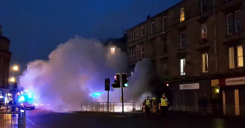
Fire coming from Repair Kings on Argyle Street in Finnieston, Glasgow.
3 February 2019 (14:15) - The Three Hats, High Street, Milton Regis, evacuated after smoke discovered
A street was closed after a pub chimney caught fire. Crews were called to The Three Hats, High Street, Milton Regis, at about 2.15pm yesterday after smoke started to fill the venue. The blaze is thought to have started from a cracked wood burner. Firefighters tackled it by pouring buckets of water over the burner. They then closed Milton High Street to use a height vehicle, brought in from Maidstone, to throw water down the chimney from the roof.
Landlord Malcolm Winskill said: "I wasn't at the pub at the time but it started filling with smoke from the wood burner which has a crack in it. That's what caused the steam and fire. Staff made sure everyone was outside. The fire brigade had to close the High Street to get the height vehicle in to look down the chimney. We have the chimney swept once a year but we're meant to do it twice a year and we've had smoke alarms fitted. I'd like to thank the fire brigade who were amazing and the customers who were there at the time." Despite the drama, the pub remained open. Sittingbourne fire crew manager, Kev Ford, said: "People who have chimneys should make sure they are swept regularly, we recommend at least twice a season.Smoke alarms should be fitted as well."
The Three Hats Inn is a Grade II listed building that lies within the Milton Regis High Street Conservation Area. It is a timber frame building constructed in the 18th century, or earlier.
News Source: Kent Online
Firefighters were called to a fire at The Three Hats
Listing Details
|
Entry Name: The Three Hats Inn
Listing Date: 13 December 1974 Grade: II Source: Historic England Source ID: 1344215 English Heritage Legacy ID: 175741 Location: Swale, Kent, ME10 County: Kent District: Swale Town: Swale Electoral Ward/Division: Milton Regis Built-Up Area: Sittingbourne Traditional County: Kent Lieutenancy Area (Ceremonial County): Kent |
Coordinates
Latitude: 51.3494 / 51°20'57"N Longitude: 0.7322 / 0°43'55"E OS Eastings: 590356 OS Northings: 164689 OS Grid: TQ903646 Mapcode National: GBR QRV.CX7 Mapcode Global: VHKJL.MBXX |
2 February 2019 (19:45) - Firefighters battle to save historic Lancashire pub from major blaze
Firefighters are battling to save a 17th-Century Lancashire pub from the flames. Crews were called to the Sirloin pub in Station Road, Hoghton at around 8pm. They reported a major blaze which had spread to the pub's roof. All customers and staff had been evacuated and it is not believed that anyone was hurt. Six crews were called out to the pub, near Chorley, as they battled to get the flames under control.
Lancashire Fire and Rescue's stinger unit and aerial ladder platform were also used before the operation was scaled back at about 10pm. At around 11.30pm the fire was brought under control, but fire crews are expected to be at the scene overnight as they work to extinguish the fire. There are currently 6 crews in attendance including support from the Stinger water tower, an Aerial Ladder Platform (ALP)and the Aerial Support Unit. Firefighters are currently tackling the fire using water from the Stinger and ALP.
The pub is a 17th Century former coaching house which re-opened in July 2016 after a major refurbishment and is full of period features including wooden beams, original stone flagged flooring, and an impressive open fireplace. The pub is not listed, but is famously at the centre of a story that has been told for centuries and puts the little village of Hoghton on the worldwide map.
(See "The Legend", below).
News Source: Lancashire Evening Post
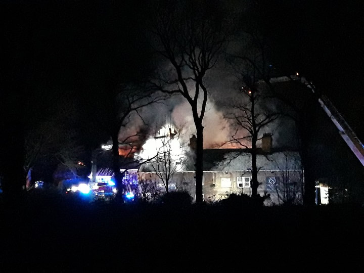
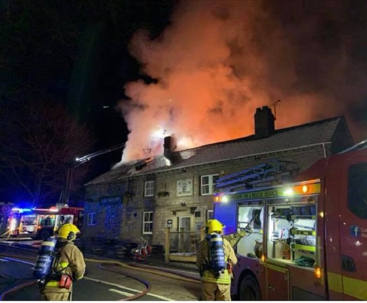
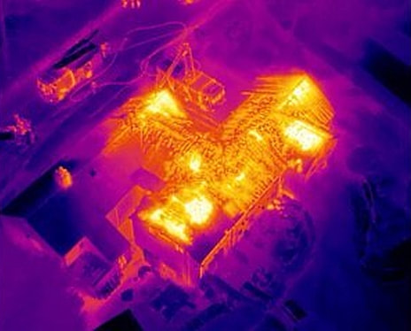
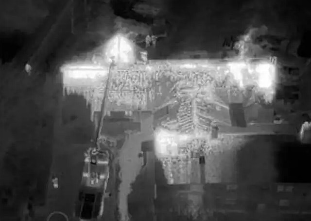
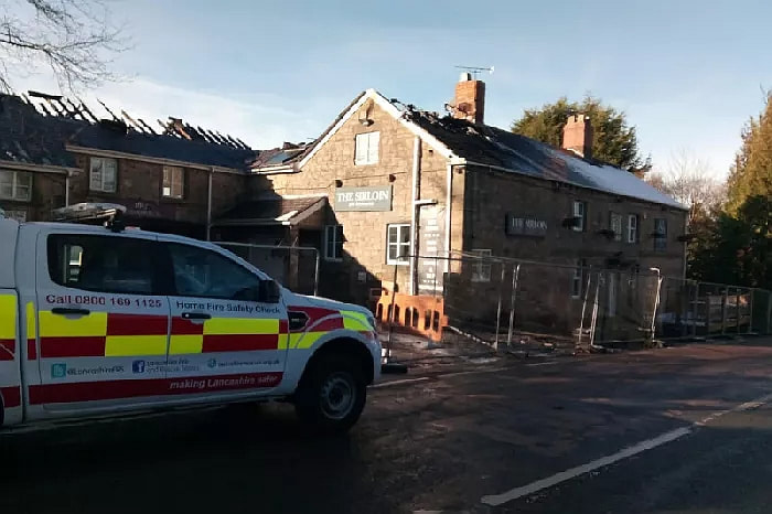
The devastating damage clearly visible the next morning
The Legend
(Researched by Heritage & Ecclesiastical Fire Protection)
Hoghton is a small and peaceful village in the north western county of Lancashire. Overlooking this beautiful village is the historic Hoghton Tower, the fortified country estate home of the de Hoghton family. Legend has it that on the 17th August 1617 King James VI of Scotland and 1st of England and Ireland, was travelling down from Scotland and chose to rest with his travelling party at Hoghton Tower. Honoured by the visit (and not wanting to disappoint such a high profile guest) the household was instructed to ensure that the most impressive banquet was prepared for the King. It is said that during the festivities King James ordered that the loin of beef being served was brought before him. Acknowledging its quality, he pulled out his short sword and declared to all who were in that room, “I pronounce this Sir Loin of beef,” from then on, the beef loin “henceforth... shall be SIR-LOIN” In remembrance of the event a pub within the parish was renamed the Sirloin Inn.
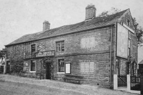
2 February 2019 (03:58) - Pub landlord taken to hospital after fire at Kings Head, Ulverston
A pub landlord was taken to hospital after becoming overcome by heat and fumes attempting to put out a kitchen fire. Three fire engines from Ulverston and Barrow were called to the Grade II listed Kings Head pub on Queen Street in Ulverston at 3.58am this morning. Fire services were at the blaze for almost two hours before it was extinguished. One man, the landlord, was rescued from the building and taken to hospital after being given first aid by firefighters.
A spokesman from Ulverston Fire Station said: “The landlord attempted to put the fire out but was overcome by the heat and fumes. Police attempted to pull him out of the property but were forced to retreat due to heat and fumes. Fire crews using breathing apparatus were able to pull the landlord out of the building. He was then taken to hospital after being given first aid by fire service crews. The smoke and the heat alone were enough to incapacitate the landlord which just goes to show it doesn’t take a lot in these situations.” The spokesman said the cause of the fire was currently unknown, but investigations have ruled out an electrical fire.
The pub dates back to the 18th century and lies within the Ulverston Conservation Area. The Character Appraisal for the Conservation Area states: “Queen St is a street with a very significant architectural presence. It consists predominantly of buildings of Grade II listed status and there are no buildings that have a negative impact on the special character or appearance of the area. The Globe Inn and The Kings Head are adjoining public houses in contrasting forms – the former in a simple, regular Georgian style with fine sash-windows with glazing bars, the latter being more vernacular in composition.”
Source: The Mail
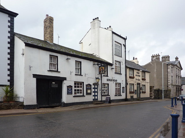
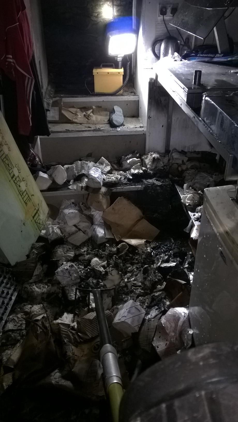
Listing Details
|
Entry Name: Kings Head Public House
Listing Date: 20 June 1972 Last Amended: 19 April 1996 Grade: II Source: Historic England Source ID: 1270186 English Heritage Legacy ID: 460013 Location: Ulverston, South Lakeland, Cumbria, LA12 County: Cumbria District: South Lakeland Civil Parish: Ulverston Built-Up Area: Ulverston Traditional County: Lancashire Lieutenancy Area (Ceremonial County): Cumbria Church of England Parish: Ulverston St Mary with Holy Trinity Church of England Diocese: Carlisle |
Coordinates
Latitude: 54.1954 / 54°11'43"N Longitude: -3.0967 / 3°5'48"W OS Eastings: 328542 OS Northings: 478288 OS Grid: SD285782 Mapcode National: GBR 6MTX.CV Mapcode Global: WH725.DTL4 |
1 February 2019 (22:31) - Aberfeldy flats gutted after blaze
Firefighters rushed to the Highland Perthshire town at around 10:30pm on Friday night after the first reports of fire and battled the blaze until past 2am on Saturday morning to ensure it was fully extinguished. Nobody is believed to have been hurt. One witness said: “It started around 11pm and tore through the upper flat in the kitchen/living room area. The person in the upper flat was awoken by the smoke and evacuated the house as did the person in the lower flat. Both properties have been badly damaged by fire, smoke and water.” At least three quarters of the roof was destroyed in the fire.
Five vehicles, including one specialist platform for reaching tall buildings, travelled to the property, which was described as being “engulfed in flames.” The crews left shortly after 2am on Saturday morning with a crew returning to Aberfeldy at 8am to ensure “all hotspots had been extinguished.” A Scottish Fire and Rescue Service spokesman said: “We can confirm that four fire appliances, including one high reach device, were called out to a property at 22:31 in Kenmore Street on Friday night. The property was fully engulfed in flames but nobody was inside the building. Crews were there until 2:05 on Saturday morning. A crew was mobilised at 8:05 this morning to ensure the fire was fully extinguished and there were no further hotspots, which there were not. 75% of the roof was destroyed in the fire.”
The Category C listed building dates to the 19th century and is situated within Aberfeldy Conservation Area. The present houses in Kenmore Street were built on the site of 18th century flax spinners cottages. The building materials used were the local chlorite slate and rubble. Up to the late 19th century many of these houses had byres and the cows were turned out in the town’s four cow parks.
News Source: The Courier
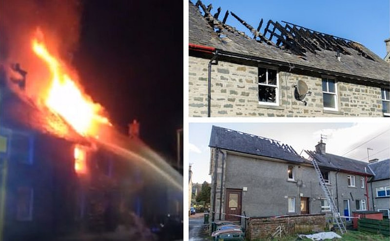
The blaze destroyed the roof of the flats
Listing Details
|
Entry Name: 12 - 16 (Even Nos) Kenmore Street
Listing Date: 5 October 1971 Category: C Source: Historic Scotland Source ID: 356045 Historic Scotland Designation Reference: LB20850 Building Class: Cultural Location: Aberfeldy County: Perth and Kinross Town: Aberfeldy Electoral Ward: Highland Traditional County: Perthshire |
Coordinates
Latitude: 56.6189 / 56°37'7"N Longitude: -3.8697 / 3°52'10"W OS Eastings: 285363 OS Northings: 749010 OS Grid: NN853490 Mapcode National: GBR JCT7.23K Mapcode Global: WH4LQ.JWHR |
Near Miss
1 February 2019 (14:50) - Bus engine catches fire near Victoria Road Calender Building in Dundee
1 February 2019 (14:50) - Bus engine catches fire near Victoria Road Calender Building in Dundee
Emergency services dealt with a bus that caught fire in Dundee city centre. The fire service received a call at 2.50pm after a fire developed in the engine of a single-deck bus at the “rear of the Wellgate Centre”. One hose reel jet and one main jet were sent to the scene. The driver was the only person on board as it was a staff shuttle bus and there were no injuries as a result of the incident.
Police redirected traffic up Hilltown while the incident was being dealt with. A Stagecoach East Scotland spokeswoman said: “One of our training vehicles, operating on Victoria Road in Dundee was involved in an incident whereby the vehicle developed a fault, and the driver detected smoke coming from the rear of the bus. There were no other employees on board the bus and the fire service were contacted for assistance. Safety is our priority and we have launched a thorough investigation into the cause of the incident.”
The burning bus was just metres away from a Category B listed, grand gothic frontage, building at 60 Victoria Road, known as the Victoria Road Calender. (See Building History below).
News Source: The Courier
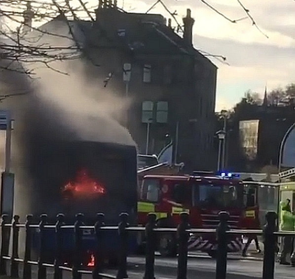
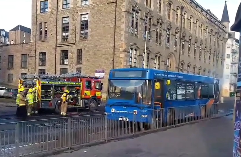
Listing Details
|
Entry Name: 60 Victoria Road, the Victoria Road Calender (A and S Henry's)
Listing Date: 4 February 1965 Category: B Source: Historic Scotland Source ID: 361291 Historic Scotland Designation Reference: LB25122 Building Class: Cultural Location: Dundee County: Dundee Electoral Ward: Coldside Traditional County: Angus |
Coordinates
Latitude: 56.4655 / 56°27'55"N Longitude: -2.9691 / 2°58'8"W OS Eastings: 340385 OS Northings: 730799 OS Grid: NO403307 Mapcode National: GBR ZB1.CJ Mapcode Global: WH7RB.CRC9 |
Building History
(Researched by Heritage & Ecclesiastical Fire Protection)
Machinery was installed by Robertson and Orchar for the Victoria Road Calendering Co., who started trading at 60 Victoria Road, Dundee, in 1875 - A calender is a machine that smooths or glazes paper or cloth by pressing it between plates or passing it through rollers - The building was acquired by A & S Henry & Co Ltd, (a Manchester based jute company) in 1910, for £7,500, who moved their Dundee Headquarters offices to the Victoria Road premises. Further extensions to the rear (now mainly demolished) were added in 1916-17 and 1929. In 1953, with the incorporation of A & S Henry & Co (Dundee) Ltd, it became part of that company.
Sack making and printing were carried out at the Victoria Road Works. The basement and ground floor were for press packing and despatching. The 1st floor was offices and 2nd floor cloth samples and attic bag sewing and stamping. The offices were very grand complete with marble fireplaces and a panelled boardroom. The panels were lost through theft when the building was empty). In 1972 A & S Henry & Co was taken over by Great Universal Stores and in the same year A & S Henry & Co (Dundee) Ltd was taken over entirely by the Titaghur Jute Factory Co Ltd.
The building has since been converted into private apartments.
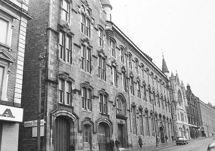
1 February 2019 (13:00*) - Crews tackling fire at Barking Road takeaway
Firefighters are tackling a fire at a takeaway in Barking Road, East Ham. The extraction system of the fast food shop, which has flats above it, is currently alight. Crews from Stratford, Poplar, Barking and Ilford fire stations were called to the scene shortly after 1pm today. The cause of the fire is not known.
The building lies within the East Ham Civic Centre Conservation Area and every building on the North side of Barking Road is Locally Listed in three groups – 383 – 413; 415 – 435; 437 – 445.
News Source: Newham Recorder
The building lies within the East Ham Civic Centre Conservation Area and every building on the North side of Barking Road is Locally Listed in three groups – 383 – 413; 415 – 435; 437 – 445.
News Source: Newham Recorder
Heritage & Ecclesiastical Fire Protection
Preventing Fire, Protecting Life, Preserving Heritage
Click HERE for Expert Specialist Fire Safety Risk Assessments for Historic and Listed Buildings
Preventing Fire, Protecting Life, Preserving Heritage
Click HERE for Expert Specialist Fire Safety Risk Assessments for Historic and Listed Buildings
Phone: 07840 351458 Email: hello@fireprotect.me.uk
January - 41 Fires & 11 Near Misses
31 January 2019 (04:45) - Fire at the Montagu Arms Hotel in Beaulieu
Fire crews rushed to a fire at a popular Beaulieu hotel this morning. Crews were called at to a chimney fire at the Grade II listed Montagu Arms Hotel in Beaulieu early this morning - only 50 yards from the local fire station. Three teams were mobilised at 4.45am this morning. Crews from Beaulieu, St Mary's and Hardley attended the incident which is reported to have been dealt with quickly and no one was injured.
Source: Southern Daily Echo
Source: Southern Daily Echo
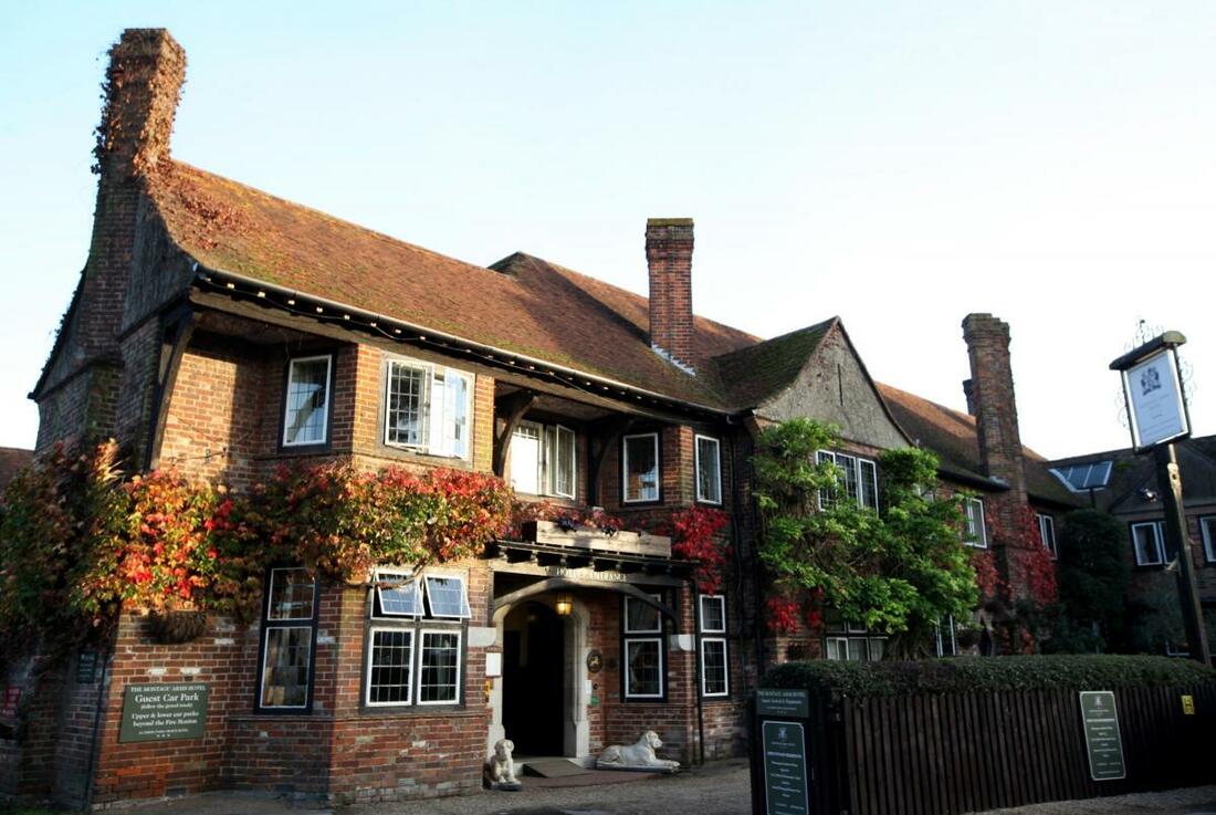
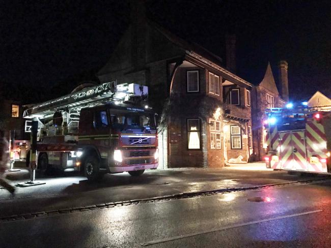
Listing Details
|
Listing Date: 1 December 1975
Grade: II Source: Historic England Source ID: 1351220 English Heritage Legacy ID: 143309 Location: Beaulieu, New Forest, Hampshire, SO42 County: Hampshire District: New Forest Civil Parish: Beaulieu Traditional County: Hampshire Lieutenancy Area (Ceremonial County): Hampshire Church of England Parish: Beaulieu Blessed Virgin and Holy Child Church of England Diocese: Winchester |
Coordinates
Latitude: 50.8183 / 50°49'5"N Longitude: -1.4514 / 1°27'5"W OS Eastings: 438739 OS Northings: 102224 OS Grid: SU387022 Mapcode National: GBR 77F.RTF Mapcode Global: FRA 76VX.VS9 |
Building History
(Researched by Heritage & Ecclesiastical Fire Protection / The Montagu Arms)
Since the 16th Century there has always been an inn on the site of the Montagu Arms. Originally a meeting place for farmers and parish officers the inn, then known as 'The Ship' and then 'The George', was very much the heart of the picturesque Beaulieu village.
The inn was a hub for timber auctions and lectures, with its own farmland a cattle market was held at the inn every year until 1809. The annual Beaulieu fairs originating from 1607 were also held at the inn as well as weekly markets.
The original building front was demolished in 1887, with the new arts and crafts style building, incorporating Monty's inn, was completed in 1888 under the direction of local architect W. H Mitchell. In 1926 a new north-east wing was added by Bizan and Fletcher to form the hotel as we know it today.
Since then, The Montagu Arms Hotel has played host to discerning clientele including Sir Arthur Conan Doyal, most noted for his fictional stories about the detective Sherlock Holmes; British Actor Henry Irving; Writer, Sir H. Rider Haggard and former French president, General Charles de Gaulle.
In 1943 the Montagu Arms Hotel was one of a number of public buildings used by the home-guard as a firing position in the event of invasion during World War 2. A scrapbook of top secret orders, letters and hand drawn maps by war-time Home Guard commander, Sir Morgan Crofton, revealed a rare insight into the real ‘Dad’s Army’ of the New Forest.
The current owners acquired the hotel in 1970 and it has remained a privately owned hotel ever since.
Near Miss
30 January 2019 - Campers who defecated on graves and started fires to be evicted from churchyard
30 January 2019 - Campers who defecated on graves and started fires to be evicted from churchyard
Homeless people who have been camping in a town centre churchyard will be ordered to leave over complaints of uncontrolled fires and defecating and urinating on graves. The tent dwellers living in land outside St Mary’s Church are due to be served notice to leave tomorrow (Thursday) by Slough Borough Council (SBC). The notice follows complaints and evidence of pitching tents on graves, memorial plaques and monuments, leaving residents unable to visit their lost loved ones.
SBC says campers have left faeces and urinated on graves and have lit uncontrolled fires which have damaged burial sites and memorials. Other grievances include public drinking and drug taking and littering. People from the camp will have until Monday, February 4 to remove all tents and other belongings. Any tents and materials still on site by 9am will be removed and destroyed. SBC enforcement team leader Ian Blake said: “The church has been patient for a very long time but the behaviour by the people living in these tents, and the tents themselves, are having a severe and detrimental effect on the area and on the relatives of those buried at St. Mary’s. We have been undertaking intensive outreach work with the people in the tents but they have been unwilling to change their behaviour or access any of the services we have sign posted them to. The most recent fire where grave sites and memorials were deliberately placed in the fire was the point where we all had to say no more.”
The council’s lead member for regulatory services Cllr Pavitar Mann (Lab, Britwell and Northborough) said: “We all feel heart-sore at the plight of some of our homeless residents and the circumstances that have driven them to camp in this way. However, there are multiple organisations who are there to help, and that we have signposted them to, but unfortunately nothing has changed. Churchyards are hallowed ground and do not deserve to be disrespected in this way. We need to take action to protect the resting places of those who have come before us.” The formal notice also gives the homeless campers the names and addresses of organisations where they can get help with homelessness and health and addiction issues.
St Mary's Parish Church is a red brick gothic style Church of England parish church in the parish of Upton cum Chalvey in the borough of Slough and the county of Berkshire in England. Built between 1876-8 to a design by John Oldrid Scott and partly funded through a personal donation by Queen Victoria. It was again enlarged in 1911-1913, and is protected as a Grade II* listed building. St Mary's Church is notable for its fine stained-glass windows, particularly the west window which is an abstract, but also in the sanctuary at the east end of the building. The grounds contain the Grade II listed war memorial by the west door of the church, inscribed with over 300 names of the dead from Slough in the First and Second World Wars. The walls and gates of the church yard are also protected Grade II listed features.
News Source: Slough Express
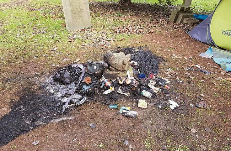
Some of the damage caused by the lighting of fires in the graveyard.
Listing Details
|
Entry Name: Church of St Mary
Listing Date: 29 September 1950 Grade: II* Source: Historic England Source ID: 1321977 English Heritage Legacy ID: 38709 Location: Slough, SL1 County: SloughElectoral Ward/Division: Central Built-Up Area: Slough Traditional County: Buckinghamshire Lieutenancy Area (Ceremonial County): Berkshire Church of England Parish: Upton-cum-Chalvey Church of England Diocese: Oxford |
Coordinates
Latitude: 51.5067 / 51°30'24"N Longitude: -0.5946 / 0°35'40"W OS Eastings: 497634 OS Northings: 179581 OS Grid: SU976795 Mapcode National: GBR F87.DHW Mapcode Global: VHFT8.ND08 |
Near Miss
29 January 2019 (17:05) - Fire breaks out above Old Market Plants in Bristol city centre
29 January 2019 (17:05) - Fire breaks out above Old Market Plants in Bristol city centre
Animals were rescued after a fire broke out above a city centre shop yesterday (January 29). A blaze had broken out in the living room of a second storey flat above Old Market Plants on Gloucester Lane in Easton. Avon Fire and Rescue were called at around 5.05pm to the residential property above the flower shop, where several small animals were trapped. Fire crews used equipment to break in to the flat and found two guinea pigs and two degus, a type of Chilean rodent. They administered breathing therapy to the four pets, who had suffered from smoke inhalation. They were then returned to the care of their owners.
In the Tweet from Temple Fire Station, they said: "Great vid from an incident tonight perfectly shows the effects of positive pressure attack, a technique used to mitigate potentially dangerous fire conditions inside a compartment & improve survivability rates of anyone inside."
The building is within the Old Market Conservation Area. Although the contribution of this building to the character of the Conservation Area is “Neutral”, it sits between a Grade II listed building and an Unlisted Building of Merit. Old Market is a Conservation Area of national significance. It is an ancient market place which developed immediately outside the walls of Bristol Castle on what was for many centuries the main road to London. The area contains some of Bristol’s most ancient buildings, including the last two remaining houses jettied over the pavement and over sixty listed buildings.
Source: Bristol Live
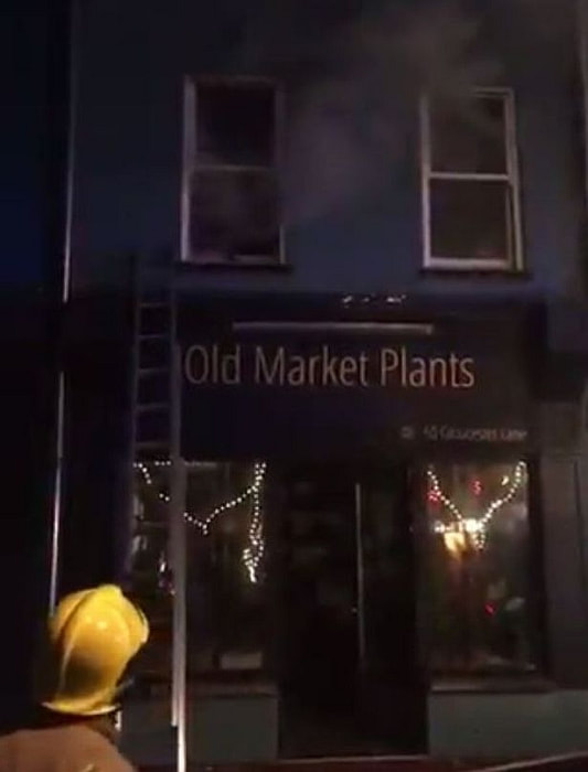
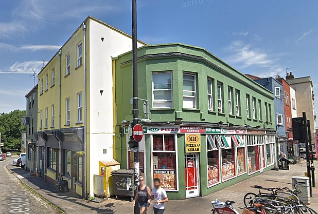
28 January 2019 (20:20) - Person rescued from flat fire above Shenanigans, Warrington
Firefighters and other emergency services were called to a flat fire on Bridge Street last night, Monday. At around 8.20pm, fire crews and police were alerted to a fire in a flat above Shenanigans. Firefighters from Warrington, Stockton Heath, Penketh and Lymm attended the scene. A person was rescued from the property. Firefighters used a hose to extinguish the fire and a large fan to clear the smoke. They were in attendance for around an hour and a half.
Shenanigans closed in November 2017 after its landlord gave up the licence to operate days before a review into the pub was set to be held by Warrington Borough Council.
The premises is part of a row of Locally Listed buildings, constructed in 1888 – 9 and known as Priory Buildings. They lie within the Bridge Street Conservation Area in Warrington.
Source: Warrington Guardian
Firefighters outside the building in Warrington
Near Miss
27 January 2019 (02:00) - Vehicles damaged in 'suspicious' fire in Chester
27 January 2019 (02:00) - Vehicles damaged in 'suspicious' fire in Chester
A moped fire which spread to other vehicles, causing them considerable damage, is being treated as 'suspicious' by the emergency services. Firefighters were called to Castle Street at around 2am today (Sunday, January 27). Police were also called and confirmed they are treating the fire as suspicious. When crews arrived, they found the scooter was ablaze and had spread to two saloon cars parked nearby.
A spokesman for Cheshire Fire and Rescue Service said: "The team swiftly attended the address and on arrival they discovered a fire involving a scooter which was well alight and had started to spread to two adjacent saloon cars. One firefighter, wearing breathing apparatus, used one hose reel jet to extinguish the fire. Firefighters were in attendance at the scene for approximately one hour." The moped has been completely destroyed, while there is extensive damage to the Mini Cooper parked behind it and to the rear of the BMW car parked in front of it.
The area where the fire was started is in the Chester City Centre Conservation Area. There are numerous listed buildings, both grade II and II* in the immediate vicinity and therefore this incident is considered a Near Miss.
Source: Cheshire Live
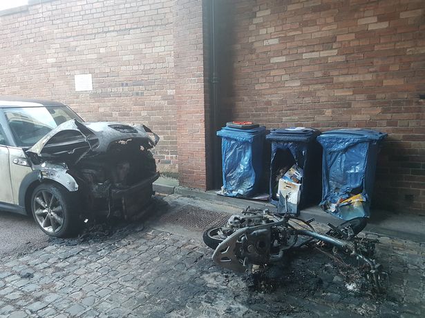
Near Miss
26 January 2019 (10:13) - Fire shuts Llandudno street for three hours
26 January 2019 (10:13) - Fire shuts Llandudno street for three hours
A fire at a restaurant closed a main shopping street for more than three hours. Fire crews were called after 10am to the Wildwood restaurant on Mostyn Street, Llandudno, after a fault in a pizza oven sparked the blaze. No one was injured but it is believed some staff were on site preparing for the store's opening at 11am. Fire service crews remained in the restaurant and part of the street was cordoned off for more than three hours as they worked at the scene. A spokeswoman for North Wales and Rescue Service said: "We were called at 10.13am to a fire involving a pizza oven on the first floor of a pizza restaurant on the lower end of Mostyn Street. It was an accidental ignition caused by an electrical fault and three appliances attended. There was fire and heat damage to the kitchen area and smoke damage throughout the restaurant." It is not currently known how long the venue will be closed for.
Wildwood is located at No 91 Mostyn Street, which is unlisted, however it is surrounded by listed buildings and forms part of the continuous line of the Victorian verandah-fronted shops and lies within the Llandudno Conservation Area. Classed as a near miss, due to its proximity to numerous listed buildings.
Source: Daily Post
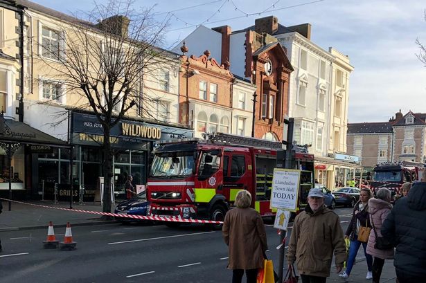
25 January 2019 (09:30) - Firefighters called to Rainford Parish Church after arson
Police are investigating after a church was "mindlessly vandalised" by arsonists. Emergency services were called to All Saints Church, on Church Road, Rainford after a fire started. The fire caused damage to the floor and ceiling in the vestry. A window at the church was also found to have been smashed. Police say no-one was hurt during the incident. A joint investigation by police and the fire service is underway to establish the cause of the fire but police say it is suspected to be a "deliberate ignition". The scene has been cordoned off by officers for examination and house-to-house enquiries are underway. A fire and rescue service spokeswoman said two engines attended the scene at around 9.30am this morning.
Detective Inspector Steve Ball said: "I am sure the people of Rainford will be shocked to discover the church, such a valued resource and focal point for the community, has been targeted in this way. It defies belief that the offender or offenders have so mindlessly vandalised a place of worship, causing damage that will take time and money to repair. I would appeal to anyone who has information to contact us so we can find those responsible."
All Saints Parish Church in Rainford is Grade II listed and was built in 1878 following a short journey from the old chapel building which was situated just inside the existing boundary line. The tower was added in 1903 and the Jubilee chapel in 1928. Some of the stained glass was taken from the former chapel.
Source: St Helens Star
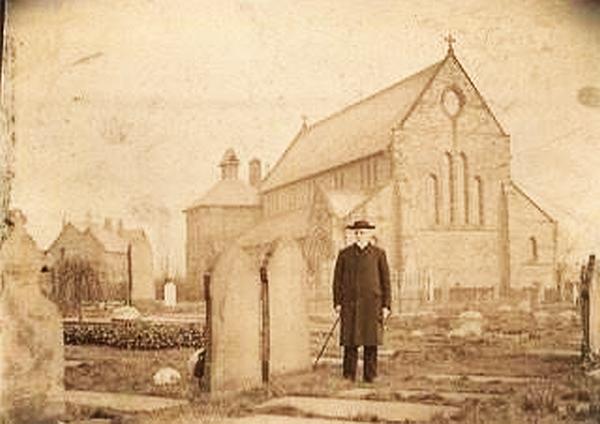
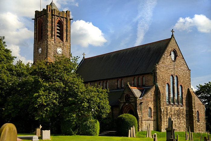
Listing Details
|
Entry Name: Church of All Saints
Listing Date: 24 March 1966 Last Amended: 23 August 1985 Grade: II Source: Historic England Source ID: 1343265 English Heritage Legacy ID: 216338 Location: Rainford, St. Helens, WA11 County: St. Helens Civil Parish: Rainford Built-Up Area: Rainford Traditional County: Lancashire Lieutenancy Area (Ceremonial County): Merseyside Church of England Parish: Rainford All Saints Church of England Diocese: Liverpool |
Coordinates
Latitude: 53.5001 / 53°30'0"N Longitude: -2.7874 / 2°47'14"W OS Eastings: 347866 OS Northings: 400668 OS Grid: SD478006 Mapcode National: GBR 8WZZ.B1 Mapcode Global: WH86Y.49Y2 |
25 January 2019 (20:00*)Blaze hits former Ardrishaig church
Firefighters battled a serious fire which hit a former church in Ardrishaig. The blaze was first reported around 8pm on Friday January 25 at the former Free Church building, close to the Crinan Canal as it passes through the Argyll village.
The church had been sold, and is understood to have been converted into a private dwelling around a decade ago. It was very badly damaged in a fire in the mid 1990's.
The building dates back to at least 1898.
Update 27 January 2019 - Safety concerns over a building gutted in a fire have led to surrounding roads in Ardrishaig being cordoned off – while fears have been raised over drivers speeding on the narrow diversion route. Argyll and Bute Council has closed Park Road and Kilduskland Road at their junction ‘for public safety’.
Fire ripped through the former Ardrishaig Free Church, converted to a family home, on the evening of Friday January 25. Four fire appliances attended after being called out shortly after 8pm and the fire was extinguished overnight. It is understood there were no casualties during the incident, which left the building severely damaged.
Source: Argyleshire Advertiser (Subscription)
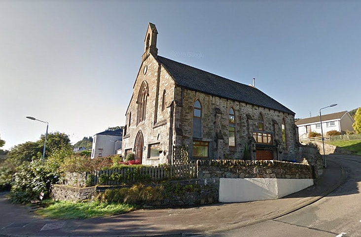

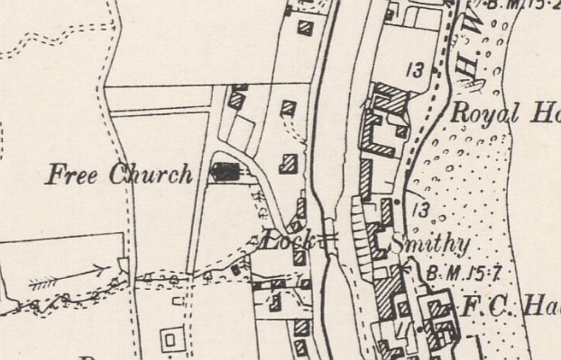
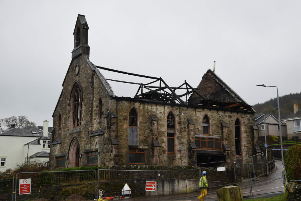
24 January 2019 (20:50) - Tarporley: Pub chimney fire fails to stop people watching football match
Not even a chimney fire could stop football fans in a Tarporley pub from watching the big game last night. The Foresters Arms on High Street was evacuated at around 8.50pm on Thursday (January 24) while firefighters dealt with the situation. But locals were able to crowd into the pub garden where landlord Stuart Hulse had set up a TV for them to watch. Chelsea ended up beating Tottenham on penalties in a nail-biting EFL Cup semi-final.
Mr Hulse said: "It was just one of those things I'm afraid. We had to evacuate for about 15 minutes so everyone was watching the game outside but they were soon allowed back in. There was no damage and we're open for business as usual." A spokesman for Cheshire Fire and Rescue Service said: "Crews used chimney rods to try and extinguish the fire, but had to tackle it from the chimney using a roof ladder. Once the fire was extinguished they used a thermal imaging camera to check the first floor and loft space for hotspots."
The Foresters Arms is a traditional Victorian Inn and lies within Tarporley Conservation Area. Evident from its name, the pub had strong links to the famous Delamere Forest wood cutters. Although the history of the pub is shrouded in a lot of mystery, the present landlord and his staff are haunted by one episode from the Foresters’ gruesome past. It is said that in the 1860’s one of the female staff members was thrown down the well at the back of the pub and died. The landlord at the Foresters was originally accused of murder, although later acquitted. There have been reports of a ghostly presence in the pub. Could the victim of this grisly attack still be searching for her killer?
Source: The Standard
The Foresters Arms in Tarporley, Cheshire
24 January 2019 (09:11) - Fire breaks out at casino building in Dartford High Street
A fire broke out in a three-storey building in Dartford High Street this morning. According to a statement from Kent Fire & Rescue Services, the fire broke out on the first floor of the Admiral Casino building. Two engines were dispatched to the scene shortly after 9am this morning with crews managing to contain the blaze using hose jets before 10am. A high-pressure fan was used to clear the building of smoke. No casualties have been reported and the cause of the blaze has yet to be identified. The building is almost opposite the NatWest building that suffered a large 1st floor fire on the 9th December last year.
Although unlisted, the building lies in the Dartford Town Centre Conservation Area and is noted as a historic building, in the High Street Character Area, that contributes positively to the character of the area.
Source: News Shopper
Although unlisted, the building lies in the Dartford Town Centre Conservation Area and is noted as a historic building, in the High Street Character Area, that contributes positively to the character of the area.
Source: News Shopper
Fire crews attend blaze in Dartford High Street. (Photo: Dan Green @DanGreen1993 on Twitter)
23 January 2019 (?) - Arsonists target historic footbridge just days after it is reopened
Youngsters started a fire on an historic Victorian footbridge just weeks after it was put back in place following a seven-month £150,000 restoration project. Grade II listed St Mary’s Bridge, within the Lydney Conservation Area, was closed for more than a decade on safety grounds before enthusiasts raised the money to make the unique piece of railway heritage safe again. But weeks after local bridge specialist Mabey put the 125-year-old iron crossing back following months of work, a fire was discovered in the middle of it.
Now bosses at Dean Forest Railway (DFR), which raised the money for the restoration, have thanked nurse Nicola Whettam and her friends for helping to save the newly-restored bridge from damage. Nicola, 44, was out running with her dog and three friends when they decided to make a detour over the iron bridge for old time’s sake. But as they approached the bridge that they once used to get to school, they noticed a “peculiar light”. “As we got closer I could see a smouldering pile of wood and cardboard right in the middle of it,” she said. “It was obviously deliberate act. I’m guessing it was kids messing about, but whoever it was certainly knew how to make a bonfire. We kicked the wood apart and stamped it all out before it caused any more damage. It wasn’t a huge fire but it’s sad they felt the need to do it because the bridge has just been refurbished and the access reopened. People in the town are very fond of it.”
Grateful DFR chiefs thanked Nicola publicly for saving the bridge which was closed for safety reasons in 2007 until enthusiasts at the railway, which runs between Lydney and Parkend, secured funds to restore it. The last remaining piece of original Severn and Wye Railway infrastructure was taken away by local company Mabey for restoration and repair last June. The bridge, which is near St Mary’s church, Bathurst Park and Lydney boating lake, was put back in place recently, restoring a public right of way linking the town and the boating lake. DFR Project manager Jane Kelly once described the bridge as “a jewel in the crown of Lydney’s industrial heritage”. Nicola said: “I wish the kids who lit the fire would find a better outlet for their energy than damaging property.”
Source: Gloucestershire Live
Listing Details
|
Entry Name: Pedestrian Bridge over Disused Rail Line, About 75 Metres East of Church of St Mary
Listing Date: 7 March 1988 Grade: II Source: Historic England Source ID: 1186609 English Heritage Legacy ID: 354458 Location: Lydney, Forest of Dean, Gloucestershire, GL15 County: Gloucestershire District: Forest of Dean Civil Parish: Lydney Built-Up Area: Lydney Traditional County: Gloucestershire Lieutenancy Area (Ceremonial County): Gloucestershire Church of England Parish: Lydney St Mary the Virgin Church of England Diocese: Gloucester |
Coordinates
Latitude: 51.7201 / 51°43'12"N Longitude: -2.531 / 2°31'51"W OS Eastings: 363412 OS Northings: 202506 OS Grid: SO634025 Mapcode National: GBR JT.2VCY Mapcode Global: VH87J.21S6 |
Building History
(Researched by Heritage & Ecclesiastical Fire Protection / DFR)
The cast iron lattice footbridge just beyond Churchfield “occupation level crossing” (where the railway crossed a private road), was first opened to the public on 26th September 1892. It was provided to combat the “serious trespass that has grown up by the workmen and others walking over the company’s railway between the engine shed and tinplate sidings and the church, the excuse being that the coal trains standing on the company’s railway opposite the church prevented them from using the public footpath through the churchyard and crossing the railway at that point”. The structure was ordered from Messrs. G. Smith & Co. of Glasgow who were to deliver and erect it for £247, the S&W preparing the foundations. The cost was in fact exceeded by £20 when it was found necessary to increase the span and lengthen the stairs.
The bridge was a great source of attraction to the local children who were apparently in the habit of sliding down the handrails, and in 1901 the Lydney local authorities pointed out the potential danger of the culprits falling off and becoming impaled on the iron railings beneath. The Committee agreed and scotched the practice for a cost of 30 shillings simply by fixing iron nuts at intervals along the handrails
2017 was the 125th Anniversary of the bridge sitting in the Lydney Conservation Area. Historic England listing states “This a very complete survival, elegant and of great economy in engineering design.” In January 2007 as the bridge was in a state of disrepair, Gloucestershire Council issued a Notice of Temporary Emergency Bridge / Footpath Closure and inclusion in the Forest of Dean District Council Buildings at Risk Register but St. Mary’s Bridge is as much needed today as when originally built, as well as being historically important to DFR as the last in-situ piece of the original Severn & Wye Railway infrastructure, it is a unique piece of historical Railway heritage. The restoration project cost £150,000 - to preserve it for the benefit, appreciation and enjoyment of future generations. Grants from the Rural Development Fund for England, Rural Tourism Infrastructure Growth Programme Funding, Dean Forest Railway and the European Agricultural Fund for Rural Development together with local donations allowed the project to proceed and local business Mabey Bridge were instructed to complete the work.
Over six days, in June 2018, sections were lifted out by the Dean Forest Railway’s own rail crane, transferred to road haulage and taken to a secure workshop for restoration and repair. Restoration included replacement of the deck section lower chords, 11 new cast iron stair risers, new deck plates, new finials on the lanterns and about 470 rivets. The restored bridge was reinstated in January 2019 and has been reopened to the public ahead of the formal opening ceremony on March 9.
Near Miss
23 January 2019 (12.00*) - Fire engines called to Buttermarket in Ipswich
23 January 2019 (12.00*) - Fire engines called to Buttermarket in Ipswich
Two fire engines were called to Ipswich town centre after reports of a burning smell led them to find a man with a serious facial injury. Crews from the Princes Street and Ipswich East stations were called about noon to attend the scene in Buttermarket, close to the corner with Upper Brook Street, in the pedestrianised centre of the town. When they got to the British Heart Foundation charity shop, a firefighter reported finding a blown fuse in an electrical intake cupboard that had caused the smell. They also found a member of the public had fallen and injured their jaw.
The shop was closed while the injured man waited with firefighters for paramedics to assess his condition. One crew left the scene at 12.55pm, while another waited for an electrician from Power Networks UK to come and assess the situation. An ambulance spokesman said: “Two ambulances were called to the Buttermarket area of Ipswich shortly before 12.30pm on January 23 following reports that a man had been injured in a fall. A patient was taken to Ipswich Hospital with a serious facial injury. All the lighting and power supply to the shop was switched off while the firefighters waited for Power Networks UK.
This is a Grade II 16th century timber-framed building with the frontage rebuilt in the early 19th century. The ground storey has an Edwardian shop front. On the 1st storey there are the original tie beams with the remains of long arched braces. There are also sections of square Jacobean panelling.
Source: Ipswich Star
Listing Details
|
Entry Name: 44, Butter Market
Listing Date: 15 December 1977 Grade: II Source: Historic England Source ID: 1236325 English Heritage Legacy ID: 427284 Location: Ipswich, Suffolk, IP1 County: Suffolk District: Ipswich Town: Ipswich Electoral Ward/Division: Alexandra Built-Up Area: Ipswich Traditional County: Suffolk Lieutenancy Area (Ceremonial County): Suffolk Church of England Parish: Ipswich St Mary-le-Tower Church of England Diocese: St.Edmundsbury and Ipswich |
Coordinates
Latitude: 52.0569 / 52°3'24"N Longitude: 1.1557 / 1°9'20"E OS Eastings: 616439 OS Northings: 244535 OS Grid: TM164445 Mapcode National: GBR TMW.4YN Mapcode Global: VHLBS.ZK9J |
23 January 2019 (11:47) - Lydia Café blaze after deep fat fryer goes up in flames
A chef escaped serious injury yesterday when trying to put out a blaze in a deep fat fryer at Lydia Café in Stoke Newington – prompting advice from the London Fire Brigade never to use water to tackle oil-based fires. Two members of staff in the café and two residents in the flats above managed to flee the building on Church Street before help arrived, with one man treated at the scene for smoke inhalation.
Six fire engines and around 40 firefighters had the blaze under control by 1.12pm – an hour and a half after the initial call came in. Part of the basement and a small part of the ground floor were damaged by the fire, which is believed to be accidental. Lydia Café thanked well-wishers on its Facebook page, confirming that no-one was hurt and that it will be “closed for a while until we fix the damage”.
A London Fire Brigade spokesperson said: “Staff saw the fire start in the deep fat fryer and the chef attempted to tackle the fire with a water fire extinguisher and fire blankets. Our advice is to never tackle a fire yourself and always get out, stay out and call 999. If you ever have an oil-based fire, putting water on it is the worst thing you can do as it can cause the oil to burst into a fireball. Thankfully, there was a fire alarm system fitted throughout this property which alerted the other people in the building.” The Brigade says it still sees a “substantial number” of kitchen fires involving deep frying with oil or fat.
The café lies within the Stoke Newington Conservation Area and is designated as a
“Building of Townscape Merit”, which is defined in the Appraisal Document: “Apart from the listed and locally listed buildings, a large number of unlisted buildings in the Conservation Area have been identified as “Buildings of Townscape Merit”. These are usually well detailed examples of mainly late 19th century houses or commercial premises which retain their original detailing. As such, they make a positive contribution to the character and appearance of the Conservation Area, and any proposals to alter or demolish such buildings will be strongly resisted by the Council. Together, these buildings provide the cohesive and interesting historic townscape which is necessary to justify designation as a Conservation Area.”
News Source: Hackney Citizen
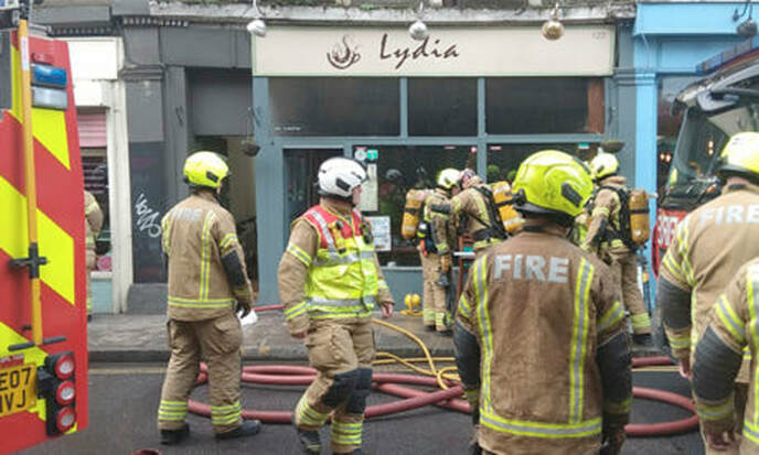
Around 40 firefighters were called out to the blaze. (Photograph: London Fire Brigade)
Near Miss
22 January 2019 (18.59) - Fire breaks out in the grounds of Oswestry church
22 January 2019 (18.59) - Fire breaks out in the grounds of Oswestry church
A fire broke out in the grounds of an Oswestry church last night (Tuesday). One crew from the town were called to St Oswald's Parish Church shortly before 7pm to reports of a fire in the open. A spokesperson for Shropshire Fire and Rescue Service said: "We were called to reports of fire in the open which proved to be a small fire which crews extinguished using buckets of water."
Records show that Christian worship has taken place on the site of the present church for more than 1000 years with the earliest place of worship (possibly a monastery) on the same site before the large church was dedicated to St Oswald more than 900 years ago. It is Grade II* Listed.
Source: Border Counties Advertizer
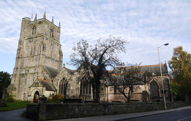
Medieval St Oswald's Parish Church in Oswestry
Listing Details
|
Entry Name: Church of St Oswald
Listing Date: 10 September 1951 Grade: II* Source: Historic England Source ID: 1054332 English Heritage Legacy ID: 255518 Location: Oswestry, Shropshire, SY11 County: Shropshire Civil Parish: Oswestry Built-Up Area: Croesowallt Traditional County: Shropshire Lieutenancy Area (Ceremonial County): Shropshire Church of England Parish: Oswestry St Oswald King and Martyr Church of England Diocese: Lichfield |
Coordinates
Latitude: 52.8571 / 52°51'25"N Longitude: -3.0578 / 3°3'28"W OS Eastings: 328869 OS Northings: 329369 OS Grid: SJ288293 Mapcode National: GBR 73.S1Q7 Mapcode Global: WH89X.0G51 |
22 January 2019 (08:25) - Angry man sets house on fire after getting evicted
A disgruntled tenant caused £100,000 of damage to a listed building when he set fire to it after being served with an eviction notice. Alan Hewson, 59, wanted to "erase himself and his belongings" when he started a series of fires at the 18th century Grade II listed building in the early hours of January 22, Hull Crown Court heard. He was "well aware" the couple and their four children who lived in the adjoining house may have been in at the time, but was too "overwhelmed and preoccupied with his own emotions" to care about the risk. The properties were separated only by a plasterboard partition. After starting fires in the living room and bedrooms in the early hours, using kindling and fire lighters, Hewson simply locked the back door and left without giving any warning. He was arrested later that day after he was seen wandering about Spurn Point. He told police "in no uncertain terms he was unhappy with his life at that time", the court heard.
Neil Coxon, prosecuting, said there was "severe" fire, heat and smoke damage to the property, and firefighters, who were alerted at 8.25am, had to force their way in, "bring the ceiling down", and smash all the windows to let the smoke out. They managed to extinguish the blaze, the main seat of which was in the living room, and no one was hurt. But the couple who owned both properties, and who had lovingly renovated them while living there for 26 years, said the insurers were still "prevaricating" about the estimated £100,000 cost of repairing the building, which they had intended to leave to their two children.
Mr Coxon said the property rented to Hewson was formerly a butcher's shop, was Grade II listed, and dated back to the early 1700s. In a victim statement read to the court by the mother, she said the effect had been "devastating" for the whole family, who felt "violated". She said they had raised their children there, and the house had been her "refuge" during the 12 months she was being treated for breast cancer. She said: "Memories of a house so loved by us all have now been tainted. Nothing can ever put that right." Hewson disputed claims he had previously damaged the property, but Judge David Tremberg said it was not the Crown court's job to settle that dispute.
In police interview, Hewson admitted he was the sole occupant, was behind with his rent due to illness, had "problems" with the landlord, and had been served with a notice to vacate. He said he had "had enough" and the eviction notice was the "catalyst" for what followed. He later admitted arson being reckless as to whether life was endangered. Stephen Robinson, mitigating, told the judge: "The defendant accepts that he is going to receive a custodial sentence today and that it's deserved. All of my comments go towards the length of that sentence, and I ask your honour to give appropriate credit for his guilty plea." Hewson suffers "regularly from low mood and excessive tearfulness", Mr Robinson said. He said "one could wholly understand" why the landlords wanted to evict Hewson, while he was worried about where he might live afterwards. He felt low; he wished to erase himself and his belongings from existence. He's aware now how serious his behaviour was, particularly for the family who lived next door."
Jailing Hewson for four years, Judge Tremberg told him: "The potential for fatal injury, not simply from the ingress of heat and fire but also smoke, was substantial. The court must send a clear, unequivocal message by way of sentence, not simply to punish you, but also to deter you or indeed anybody else who may feel that setting fire to domestic premises is in some way some mechanism that may overcome or alleviate their emotional problems. If you or anybody else sets fire to domestic premises in situations like this you will go to prison for a sentence measured in years."
News Source: Hull Live
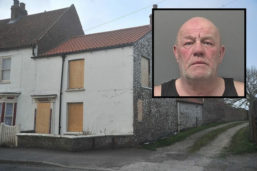
Alan Hewson destroyed the house
Listing Details
|
Entry Name: North House
Listing Date: 27 February 1987 Grade: II Source: Historic England Source ID: 1366251 English Heritage Legacy ID: 166596 Location: Patrington, East Riding of Yorkshire, HU12 County: East Riding of Yorkshire Civil Parish: Patrington Built-Up Area: Patrington Traditional County: Yorkshire Lieutenancy Area (Ceremonial County): East Riding of Yorkshire Church of England Parish: Patrington St Patrick Church of England Diocese: York |
Coordinates
Latitude: 53.6847 / 53°41'4"N Longitude: -0.0111 / 0°0'39"W OS Eastings: 531449 OS Northings: 422747 OS Grid: TA314227 Mapcode National: GBR XTCT.DW Mapcode Global: WHHH7.SNX4 |
20 January 2019 (16:50) - Huge fire breaks out at 400-year-old thatched cottage
Dozens of firefighters are battling through freezing temperatures tonight to put out flames at a 400-year-old thatched Grade II listed cottage in Ardleigh near Colchester. Nine fire crews from across Essex were called to Blue Barn Cottage in Harts Lane, Ardleigh, just before 5pm today to reports of a fire in the roof. When they arrived they found the thatched roof of the building completely engulfed in fire, with 12 crews fighting the blaze at the scene. Some were called from stations as far away as Braintree. Hotspots within the fire caused flames to burst through the thatched roof as it was being taken down – with emergency workers just inches away from the blaze as they attempted to extinguish it.
Speaking at the scene, incident commander Lee Lucas said: “The only way to fight this fire was to pitch ladders up to the roof to remove the thatch – by the time we had done that it had broken through. We’ll keep removing the thatch so we can get to the timbers underneath and extinguish the fire that way. We’ve had 12 pumping appliances here tonight but we are now at a point where we can relieve these crews and six more will carry on fight this all night. He added: “All the firefighters are using breathing apparatus and working at height rigs to stay safe in their teams. We are using a traditional form of firefighting – it’s our crews using forks to pull the thatch down, soaking it and extinguishing it. The dangers we have at this incident are the lack of light and cold conditions though the night so to mitigate this we’re using the thatch to line the road and stop the ice forming.” Fire chiefs said no-one is believed to have been hurt as a result of the blaze.
Station manager Martyn Hare said: “We also have crews inside the building, salvaging historical contents and protecting the property from further damage. Often thatch fires can take a lot of man-power to tackle and our firefighters are doing a brilliant job in difficult conditions.”
Hotspots within the fire caused flames to burst through the thatched roof as it was being taken down – with emergency workers just inches away from the blaze as they attempted to extinguish it. At 11.30pm the firefighters had removed around 90% of the thatch while crews continued to dampen down burning material and the surrounding areas. The crews pumped water and forked out burning thatch to control the fire before relief firefighters were able to completely extinguish it. The fire was finally put out completely by 6.30am.Two fire crews remained at the scene into Monday to monitor the wreckage while an investigation into the cause of the fire got underway. The owners of the property have declined to comment. Fire chiefs said no-one was hurt in the blaze.
Source: EADT
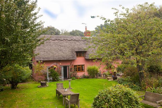
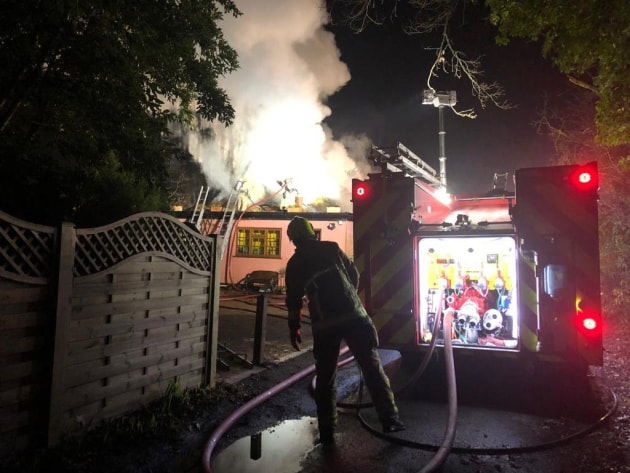
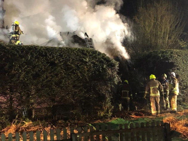
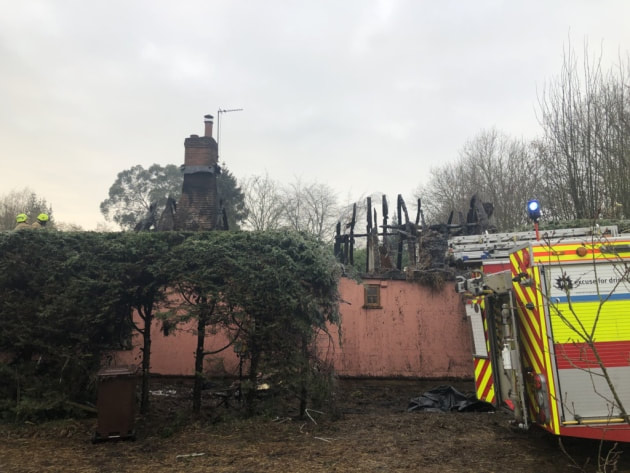
Listing Details
|
Entry Name: Blue Barn Cottage
Listing Date: 30 November 1987 Grade: II Source: Historic England Source ID: 1147610 English Heritage Legacy ID: 120363 Location: Ardleigh, Tendring, Essex, CO7 County: Essex District: Tendring Civil Parish: Ardleigh Built-Up Area: Hart's Lane, nr Langham Traditional County: Essex Lieutenancy Area (Ceremonial County): Essex Church of England Parish: Ardleigh St Mary the Virgin Church of England Diocese: Chelmsford |
Coordinates
Latitude: 51.9334 / 51°56'0"N Longitude: 0.9484 / 0°56'54"E OS Eastings: 602787 OS Northings: 230208 OS Grid: TM027302 Mapcode National: GBR SMN.LMK Mapcode Global: VHKFT.DN6P |
20 January 2019 (02:00*) - Lathom pub will temporarily close after huge fire caused "substantial damage"
A popular historic pub in Lathom has closed temporarily due to the damage caused by a huge fire. The blaze broke out at around 2am on Sunday, January 20, at The Ship at Lathom, on Wheat Lane, near Ormskirk. Firefighters were called to the fire where members of the public were reported as still being inside, and arrived to find the ground floor kitchen "well alight." Crews were on scene for around three hours, and used firefighting equipment to tackle the fire. However, the blaze had caused "extensive damage" to the ground floor of the building and its contents.
As a result of the damage, The Ship have taken to their Facebook page to confirm that the venue will be closed temporally. The post said: "An initial inspection by fire officers looks like an electrical fault is the cause. This has caused some quite substantial damage which means we will be shut for the time being. Although it is pretty devastating news for ourselves and the team, fortunately everyone is safe and well."
Lancashire Fire and Rescue Service confirmed that occupants of the building received a precautionary check by the Ambulance service and did not require hospitalisation. A spokesperson said: "The crews forced entry into the building and two breathing apparatus teams with firefighting equipment tackled the fire before searching the property to ensure no persons were trapped. The occupants of the building were located and confirmed that everyone was out and the property was empty. They had been warned of the fire by the fire alarm which was sounding on the ground floor. The fire was extinguished fully and on this occasion, there were no casualties, but the fire caused extensive damage to ground floor and contents." Staff at The Ship are currently working their way through contacting existing bookings, and providing alternative options for customers to dine at their sister pub The Cricketers. They aim to be able to reopen the venue to the public "as soon as possible."
Source: Accrington Observer
The Ship was originally a row of 18th century cottages or workshops beside the Canal (Photo: Visit Lancashire)
Building History
(Researched by Heritage & Ecclesiastical Fire Protection)
The Ship on Wheat Lane (once ‘Wet Lane’) in the ancient parish of Lathom is a local icon. It was first a Public House at 4 Wheat Lane in the 1770’s , which is contemporary with the opening of the Rufford Spur of the Leeds – Liverpool Canal, beside which it stands. It was originally a row of cottages or workshops, and eventually the Inn expanded into numbers 6 and 8 in the 19th century, and latterly extended further in 1993. The pub lies within the Canal Character Zone of the Top Locks Conservation Area in West Lancs. It is described as an unlisted building that makes a positive contribution to the character or appearance of the Conservation Area.
The Conservation Area Appraisal Document says, “The Ship Public House holds a prime position within the Conservation Area and was the main meeting place for many of the travellers and workers at Top Locks. It has been noted that the local men used to give the maids working in the pub a bucket of pig’s blood. This blood would then be used to make black pudding and in return for the bucket of blood the person would gain a free pint of their finest ale. It is from this anecdote that the local name for the Inn, “The Blood Tub”, [or just “The Tub”], is said to have derived.”
19 January 2019 (13:00*) - Fire at West Chiltington pub
A fire broke out in the chimney of a West Chiltington pub this afternoon (January 19). A number of fire engines were sent to battle the blaze at The Queen’s Head, The Hollow, at about 1pm. According to staff at the pub, it was a small fire which was put out quickly by firefighters, and business was not affected.
The Queen’s Head is a Grade II listed building dating back to at least the 18th century.
Source: Worthing Herald
The Queen’s Head is a Grade II listed building dating back to at least the 18th century.
Source: Worthing Herald
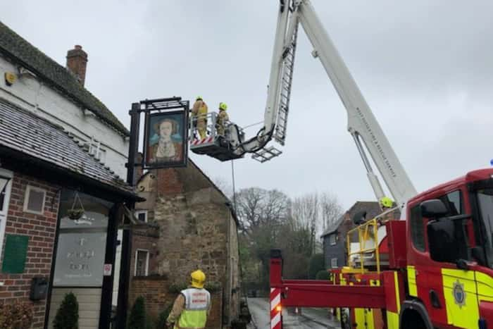
Firefighters on scene at the Queen's Head (Photo: Eddie Mitchell)
Listing Details
|
Entry Name: The Queens Head Inn
Listing Date: 9 May 1980 Grade: II Source: Historic England Source ID: 1284594 English Heritage Legacy ID: 298998 Location: West Chiltington, Horsham, West Sussex, RH20 County: West Sussex District: Horsham Civil Parish: West Chiltington Built-Up Area: West Chiltington Common Traditional County: Sussex Lieutenancy Area (Ceremonial County): West Sussex Church of England Parish: West Chiltington St Mary Church of England Diocese: Chichester |
Coordinates
Latitude: 50.9554 / 50°57'19"N Longitude: -0.4492 / 0°26'57"W OS Eastings: 509017 OS Northings: 118475 OS Grid: TQ090184 Mapcode National: GBR GJJ.17T Mapcode Global: FRA 96YL.8S6 |
Near Miss
19 January 2019 (12.00*) - Human poo found dotted inside church and fire attempted
19 January 2019 (12.00*) - Human poo found dotted inside church and fire attempted
A community is outraged after learning that human poo has been left in their church and an attempt made to start a fire. The sickening act took place in the town’s Old All Saints Church, Skelton on Saturday between 8.30am and 3.30pm., leaving worshippers upset. The Church custodian, John Connolly, shared his upset on Facebook following the incident at the town's Old All Saints Church.
He shared how he had earlier been running a tombola table in the Saltburn Emmanuel Church hall, and said he'd left the front door of the old Skelton church open during the day before returning to lock up at 4.15pm only to find the miserable discovery. He posted: "We'd had a visitor. He or she had left samples of excrement dotted around the entrance and aisle areas, then generously smeared a deposit upon the visitors book. An attempt to set fire to one of our postcards failed - pretty damp conditions prevail in winter - and our “Postcards for Sale” notice had been burned.” Mr Connolly initially did not inform police saying: "I suspect they’ll not be eager to test samples for DNA ID”. But he said he did have a “sample of handwriting” which could provide a clue to the perpetrator and has since contacted the police. It took 45 minutes for the red mist to recede after I saw what had happened. Over the last 12 years we've never had a problem at all."
News of the vandalism, shared on the Skelton in Cleveland public Facebook group, prompted a shocked reaction. One post, which summed up the general reaction, read: “Absolutely sickening that someone could do something like that to a beautiful building. Hope you find the culprits.” Another wrote: “I can’t understand what people get out of trashing and spoiling others’ things. At some point they might need help from a church or a family member and think back to what they did. Terrible - no need for it - no respect.” And one post called the act “appalling” and “vile” - “and more so in a place of worship.”A Cleveland Police spokeswoman said: "We would welcome information from anyone who can help identify the person, or people, responsible for these despicable actions.
There was a medieval church where Old All Saints Church stands, but that was replaced with the current building in 1785, which is Grade II* listed. One wall of the medieval church was retained, and a selection of medieval monuments. A new All Saints church was built nearby in 1884 and the Georgian church fell into disrepair. It was declared redundant and is now looked after by the Churches Conservation Trust.
Source: Teeside Live
Listing Details
|
Entry Name: Old Church of All Saints
Listing Date: 25 May 1966 Grade: II* Source: Historic England Source ID: 1263246 English Heritage Legacy ID: 432703 Location: Skelton and Brotton, Redcar and Cleveland, TS12 County: Redcar and Cleveland Civil Parish: Skelton and Brotton Traditional County: Yorkshire Lieutenancy Area (Ceremonial County): North Yorkshire Church of England Parish: Skelton with Upleatham All Saints Church of England Diocese: York |
Coordinates
Latitude: 54.5624 / 54°33'44"N Longitude: -0.9924 / 0°59'32"W OS Eastings: 465252 OS Northings: 519038 OS Grid: NZ652190 Mapcode National: GBR PHHP.Y9 Mapcode Global: WHF87.QLM8 |
19 January 2019 (09:39) - 10 fire appliances battle fire at former Arena nightclub
Fire crews are tackling a "large fire" at the former Arena nightclub in Middlesbrough, currently being used as a gym. Smoke could be seen filling the air from the roof of the building on Annie Street, just off Newport Road on Saturday morning. Ten fire appliances were at the scene with firefighters seen readying their equipment as they prepared to go inside. Some put on breathing apparatus before entering the front of the building. Crews were seen coating the roof of the building in water as they attempted to halt the blaze. The sound of sirens filled the air as around a dozen people gathered in the street to watch.
A fire brigade spokesperson said: "Cleveland Fire Brigade were called at 9.39am and are currently in attendance at the old Arena nightclub, Newport Road, Cannon Park in Middlesbrough. We have ten fire fighting appliances in attendance, we have an aerial ladder platform and command and control with supporting appliance. This is a fire involving the building, further updates will follow." The spokesperson described the blaze as a "large fire". An eyewitness told Teesside Live: "The Arena in Middlesbrough is well ablaze. Around six fire engines are there and the area is taped off." The cause of the fire is not known at this time.
Sarah Thomas who trains at the gym with her partner and five-year-old daughter said: "We have only been training there for two months; we are still getting to know everyone. We are all devastated for Nathan as he has put so much effort in to making this a great place for adults and children in local the community. When we turned up for the kids kickboxing class on Saturday, he was just stood outside devastated. I hope everyone will rally around to help him with whatever he needs to get this place back together." Teesside Live approached the gym for comment but they declined.
Although the building has no listing credentials, it does have more than 100 years of history in the town, holds special memories for many and has had a significant influence on the music scene in Middlesbrough during the 1960s to 1990s. The venue is featured in a book “Middlesbrough in 50 Buildings” which highlights landmarks that have made their mark on the town.
See the Building History below.
Source: Teeside Live
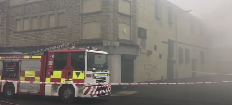
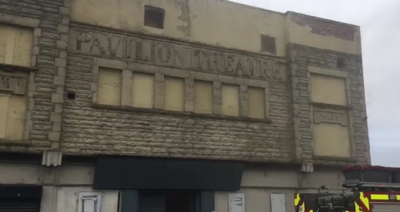
Building History
(Researched by Heritage & Ecclesiastical Fire Protection / Bug and Flea)
The Pavilion Theatre was opened around July 1913 presenting drama & comedy plays. It had a 22 feet wide proscenium. It was converted into a cinema in March 1914, and was re-named Pavilion Picture House. It was operated by Thomas Thompson. In March 1928 it was sold to Denman Picture Houses Ltd./Gaumont British Theatres chain. In 1930 it was equipped with a British Acoustic(BA) sound system. Around 1935 the Pavilion Cinema was taken back by Thomas Thompson.
The Pavilion Cinema was closed in 1957 and it was converted into a discotheque called Club Marimba and Jerry Lee Lewis played there in November 1966. It was called Sloopy's in the late 1960s. It was closed in 1973 when it was damaged by a fire. The upper floor of the façade was removed. In the 1970s it was known as the Rock Garden, a Punk Rock Venue. In 1977 the Sex Pistols appeared there as "Acne Rebel" because of management problems. It later became La Roche nightclub when Don Laroche bought the club, and was also known as Bier Keller and The Cavern in the 1980’s. It was renovated in 1991 and re-opened as a rock concert venue and in 2007 became a nightclub named Arena and it continued as such until closure. In 2011, the Arena was named seventh best nightclub in the UK by the magazine DJ Mag. The club was lauded as the 76th best in the world in the annual poll which was voted for by readers. The building was considered derelict in 2013, but has recently been brought back into use as a gym called Akurei MMA.
Its historical frontage is still as it was when it was built, although rather weathered, with the carved name and the words “Drama” and “Comedy” still visible on the building.
17 January 2019 (20:23) - Caravan which caught alight sparks major fire operation
A caravan which caught alight sparked a large scale fire operation as it set ablaze to a neighbouring house. The derelict property on Kilmarnock Road in Monkton (the former Muirhouse Lodge Hotel) went up in flames last Thursday night as the caravan attached to it caught fire. Four fire engines raced to the scene to tackle the blaze, and an aerial appliance was also mobilised by Scottish Fire and Rescue service. Firefighters battled the flames well into the night. The road remained closed after 11pm, eyewitnesses said. And a fire engine stayed at the scene the following morning.
One eyewitness said: “The house was right up in smoke. It was a big fire and luckily they got it when they did or it could have been worse.” A Scottish Fire and Rescue spokesman said: “We were alerted at 8.23pm on Thursday, January 17 to a fire involving a caravan attached to a derelict property in Monkton. Operations Control mobilised four fire engines and an aerial appliance to the scene, on Kilmarnock Road, where crews extinguished the fire, which had partly spread to the adjacent property building. There were no casualties. A single fire engine remains at the scene this morning (Friday, January 18) to ensure the area remains safe.”
This historic building was originally a 19th century coaching house, called Muirhouse, that was first used by Irish Monks as they arrived from Ireland and settled in this part of Ayrshire, and hence the name “Monk Town” or Monkton was born. The ruins of the former stables are still visible at the rear of the property.
Source: Daily Record
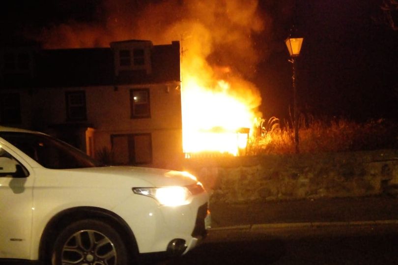
17 January 2019 (20:00*) - Fire breaks out on second floor of Marklands building, Tyldesley
A fire broke out last night, Thursday, on the second floor of a building that was in danger of collapsing last year. Three fire engines were called to the second floor of the Marklands building on the corner of Elliott Street and Stanley Street in Tyldesley at around 8pm where a blaze had broke out. A Greater Manchester Fire and Rescue Service spokesman said a 13m ladder, breathing apparatus and a hose reel were used to bring the fire under control. Crews were on the scene for around one hour and 20 minutes. The spokesman added that the cause of fire is unclear.
The town centre building, which has 14 flats above the shops, was evacuated last June after Wigan Council said it was at risk of collapsing. Residents who lived there were forced to leave. Elliott Street, the main road in the town centre, was closed off causing a detrimental effect on businesses. Seven months on, scaffolding remains at the building, which is privately owned, with business owners uncertain about when the situation will be resolved. The owner of the building has paid for residents of the flats to stay at a hotel while the work is being done. Eight of the flats had people living in them.
This prominent Victorian heritage building was originally built as a hotel for the business people visiting Tyldesley’s mills and collieries. It lies within the Tyldesley Town Centre Conservation Area and is now regarded as being part of the fabric of the town.
Source: Leigh Journal
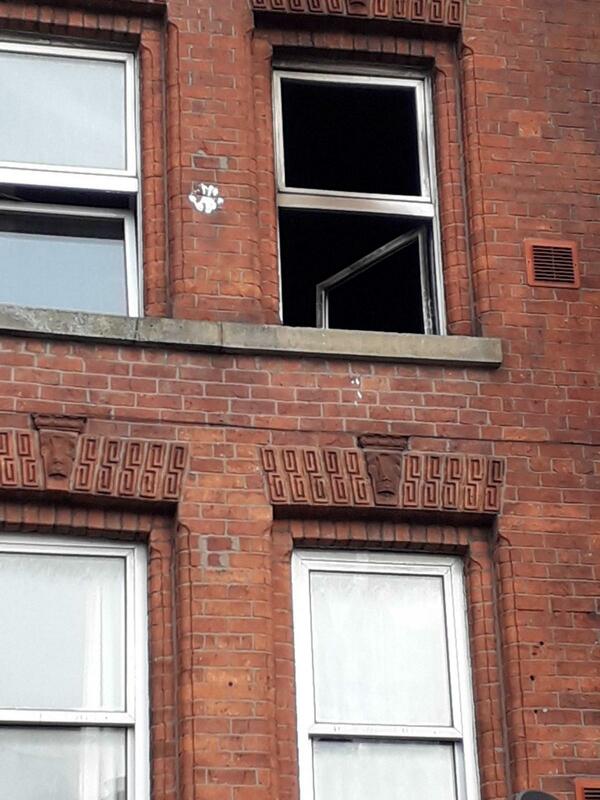
Near Miss
17 January 2019 (17:00*) - Fire at Bull Ring chip shop, St John's
17 January 2019 (17:00*) - Fire at Bull Ring chip shop, St John's
Firefighters have attended a fire at St John's chip shop this evening. Crews were called to the fire at the Bull Ring chip shop in St John's fire at around 5pm. Staff at the shop told us the firefighters extinguished the small fire and left around 7pm. Staff have been cleaning up and were assessing the damage, so have closed the shop for the evening.
The Chip shop, although not statutory or locally listed, does lie within the St John’s Conservation Area. The area is locally referred to as the "Village in the City" which is partly due to the area being an independent township before joining the city. The Chip Shop building, No. 4 St John’s, and adjoining No. 2 (locally listed) are identified in the Appraisal Document as being in a poor state of repair. No. 6, on the other side of the Chip Shop is Grade II listed.
Source: Worcester News
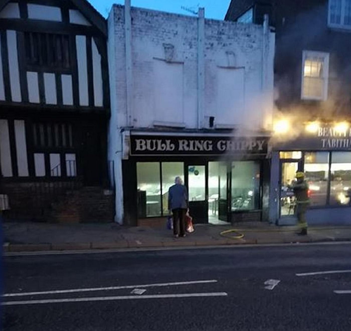
16 January 2019 (22:36) - Five fire crews battle blaze at former Wolverhampton Eye Infirmary
Firefighters from across the Black Country have tackled a fire at a dilapidated eye infirmary in Wolverhampton. Around 23 firefighters fought the blaze at the Locally Listed site in Compton Road, which has stood empty for more than 10 years. Nearby Merridale Road was closed at around 11pm as five fire engines were sent to douse the flames in the four-storey building, which closed in 2007.
A spokesman for West Midlands Fire Service said: "We received a call at 10.36pm yesterday evening. It was a 999 call to Compton Road in Merridale. We sent five appliances to the scene – four fire engines and one brigade response vehicle. The incident involved a fire in a four-storey tower of a disused eye infirmary. We had three main water jets on the blaze and about 23 firefighters at the scene. We still have one crew at the scene, making sure the fire does not flare up again. We left at 12.34am. There will be an inspection carried out in daytime hours. Investigations are ongoing."
It comes during a dispute between Wolverhampton Council and The Royal Wolverhampton NHS Trust which owns the site. The two authorities are currently in a court battle over an enforcement notice served last February following allegations the NHS trust had failed to keep the site in a reasonable condition. It gave a total of seven months to sort a raft of issues including replacing broken windows, clearing vegetation, removing rubbish and repairing perimeter fencing. Trust bosses were also ordered to replace damaged windows and doors, as well as areas of the roof. The council claimed not all work was completed by the September 20 deadline. But the NHS trust has lodged an appeal and is calling for the notice to be quashed or amended.
Ms Alison Ogley, on behalf of the trust, told Dudley Magistrates’ Court the notice was ‘fundamentally flawed’ and was served ‘abruptly’ by the council. She added: “The notice is unreasonable on its face, as is the time scale. It is, in my submission, manifestly unfair. It is rather extraordinary that the council has seen fit to make such serious allegations against another public body.”
In court it was revealed how the council had offered £1 to buy the site, having previously made bids of up to £1.1 million in January 2017. Wolverhampton Council’s low bid was tabled just after it had served an enforcement notice on the trust to carry out urgent repairs, Dudley Magistrates Court heard. It was rejected before the council upped the offer to £350,000 and then to £550,000 just before Christmas last year, but The Royal Wolverhampton NHS Trust instead accepted an offer from private investors from BZ Property Holdings Ltd.
There are three principal buildings on this site: the original Infirmary of 1888; the Nurses' Home of 1927; and the Outpatients'/Accident and Emergency Extension of 1937. These buildings are quite different in style but all are of definite architectural and historic interest and all were designed by significant local architects.
All three buildings are Locally Listed and all are in the Oaks (Merridale Road) Conservation Area. A full history of the Infirmary can be found below. It is apparent that the Eye Infirmary has been very important in the social and health history of the city. It has been a greatly appreciated facility in which there was a good deal of local pride.
Source: Express and Star
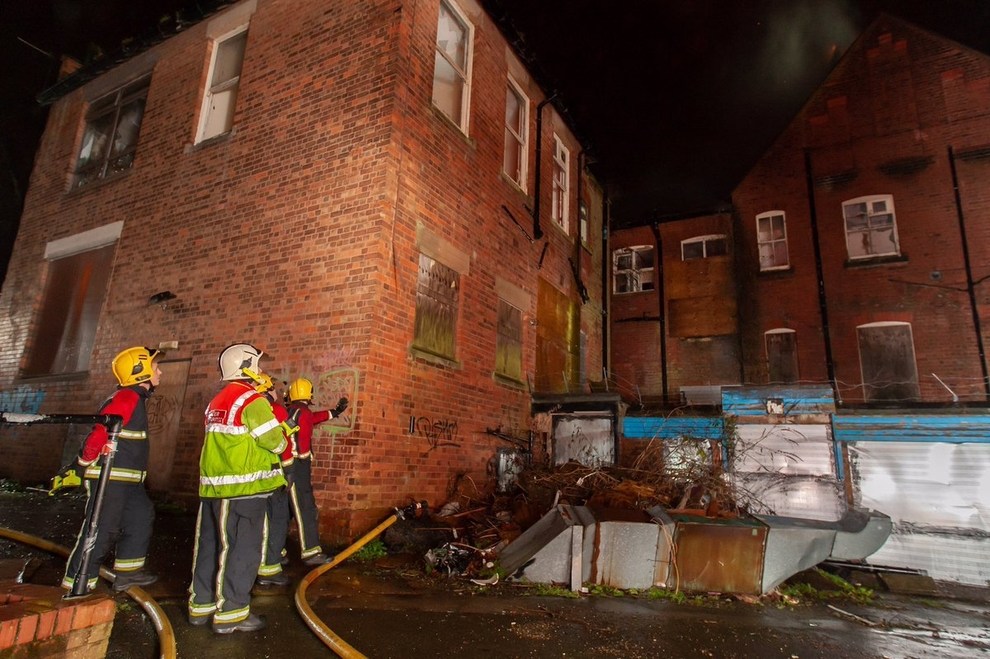
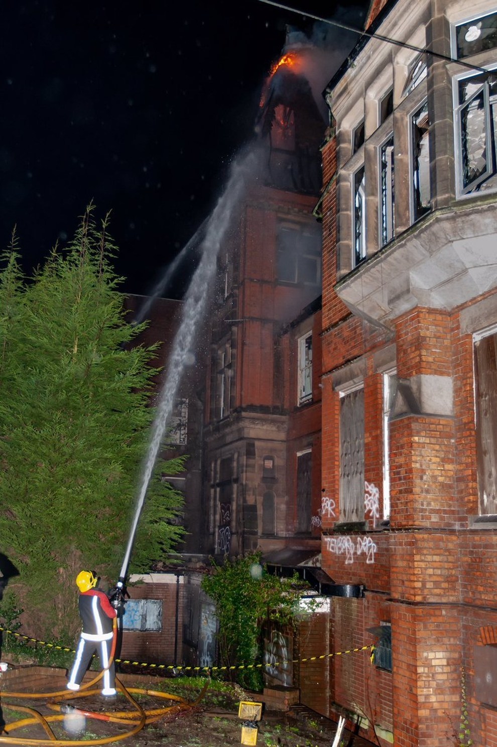
Building History
(Researched by Heritage & Ecclesiastical Fire Protection / Roy Stallard)
In the immediate years after the Royal Hospital opened its doors, industry considerably grew, rail travel and services expanded rapidly and there was considerable vitiation and air pollution apparent. Resulting from these strictures and the poor social conditions in the area, there became a pressing need for appropriate treatments for eye conditions. Whilst some initial relief was obtained at the Royal Hospital, it was clearly unable to cope in this specialised area.
Philanthropists in Wolverhampton gathered again under the auspices of the Briscoe family, Edward Banks and Dr. William Millington in 1881, and rented a house in St Mark's Road to provide eye care. Within the first year, some 2264 cases had been treated, with 50 patients a day queuing outside for care and ward numbers for in-patients had been extended to 13. All patients were treated irrespective of ability to pay or subscriber tickets from employer or local Minister of Religion.
In late 1884 it became apparent that the facilities were insufficient and there was a great need for a larger structure. Mr. Philip Horsman (Art Gallery benefactor) undertook the erection of such a building at his own expense, i.e. £5000, provided that the existing necessary amount of £8000 was raised locally. Land was purchased from the Duke of Cleveland in Chapel Ash and the new buildings were opened on October 23rd 1888 by the Earl of Dartmouth, providing three men's and three women's wards with thirty beds and five children's cots.
It is constructed of red brick with elaborate brick details and stone dressings. It is built to an irregular plan in a simple Gothic style under a plain clay tiled roof with crested ridge tiles and two spired turrets, one of which has an inscribed stone plaque bearing the legend: "EYE INFIRMARY AD 1887. Some of the original sash windows have been replaced and late 20th century extensions to the original west front have detracted from the character and appearance of the original building. Names amongst the benefactors included Barlow & Son, W. H. Butler, Messrs Crane, Gibbons, Hickman, Hodson, Jenks and Graham; the construction was undertaken by H. Willcock, gas fittings by Meynell and electricity by Hartill; T. H. Fleeming was the architect.
In addition to Dr. Millington, Dr. Chesshire had joined the staff and saw O.P.D. patients on four days a week. Provision of funds came from prominent local businessmen, a workmen’s fund and legacies; hospital Saturday and Sunday funds added to the totals By the year 1893, some 12,000 patients were being treated annually. In the early 1900s, land was purchased on which the Nurses Home now stands and a Porters Lodge was built. At the outbreak of World War 1, annual patient numbers treated had risen to 23,000 and 25 beds were set aside for war victims. Queen Alexandra Day collection was initiated and raised £4,500 from the general public in its first appeal. In the immediate war aftermath, many administrative changes took place and funding increased. A complete renovation of the operating theatre was undertaken at a cost of £1,200 and new heating structures added. In the mid twenties, Dr Campbell Orr joined the staff and a new Nurses Home was constructed, furnished generously by 'Two Old Friends', and an ultra-violet unit was opened. By the thirties, total income had grown to £10,000 and a total of 142,000 patients were being treated annually.
The resident medical staff now included many overseas staff from the wider Commonwealth. A fund was set up to provide a new O.P.D., pharmacy and A/E facilities and these opened in 1937, much improving In and Out patient facilities. With the advent of World War II, much provision was made for the war wounded and numbers treated from the immediate locale totalled 100,000 per annum.
Immediately after the war, Compton Hall (now the hospice) was purchased to provide extra staff facilities, a male and female nurse training school was established and arrangements were made for local industrial nurses to receive training for the treatment of industrial eye injuries. 1948 saw the hospital absorbed as part of the new NHS; whilst the scale of factory-based eye trauma continued at high levels, Wolverhampton Eye Infirmary became recognised both nationally and internationally as a centre of renown for corneal grafting. Throughout the seventies and eighties, with a much stricter provision of health and safety acts, the scale of injuries diminished sharply. This was somewhat balanced by an increase in ocular conditions from migrants from the sub continent of Asia. A complete new theatre block was opened in 1980 with the original single theatre being converted to a hospital chapel, stained glass windows from the local redundant church of St Mark's were added.
The advent of day case surgery for cataracts and other eye conditions and better available ophthalmic drugs saw the bed numbers sharply diminish in the nineties, and with the transfer of night emergency services to the New Cross hospital, the local health care trust decided, in 2004, to close the Eye Infirmary, and moved all its services to New Cross Hospital in 2007. These buildings have been empty ever since and are, therefore, at risk and sympathetic new uses need to be found for them. As the grounds in which they stand are now crowded and suffering from poor landscaping and neglect, any re-development should be treated as an opportunity to greatly improve the setting of these buildings.
Near Miss
16 January 2019 (19:40) - Firefighters tackle blaze near Romford pub
16 January 2019 (19:40) - Firefighters tackle blaze near Romford pub
A storage shed at the back of a Romford pub caught fire last night.
Fire crews were called to a fire close to the Durham Arms pub in Brentwood Road at around 7.40pm on Wednesday, January 16. A single storey outbuilding caught alight and there was 100 per cent damage to the building. No-one was injured in the fire and fire crews left the scene shortly after 9.30pm. Police also attended the scene and enquiries into the cause of the fire remain ongoing.
The Durham Arms is a Locally Listed building of Architectural and Historical Interest. Havering Borough’s Heritage Asset Register describes the pub as, “a prominent building within the street scape of this area, suiting its role as a significant social hub. It is a good example of Victorian tavern architecture, and one of few historic buildings in an area which has seen much modern development.”
Source: Romford Recorder
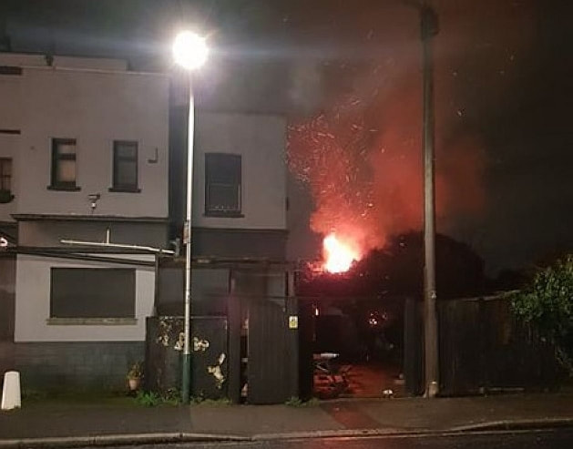
The fire started in a wooden shed adjacent to the pub.
16 January 2019 (07:42) -Two rescued from Walworth Road fire
Two people were dramatically rescued from a burning building on Walworth Road this morning. London Fire Brigade said firefighters wore breathing apparatus as they scaled a ladder to help a man and woman from a first floor flat. The woman was treated at the scene for smoke inhalation before being taken to hospital by paramedics. Six other people had been able to escape from the building before firefighters arrived. Ten fire engines and around 70 firefighters were at Walworth Road to tackle the blaze at a shop with flats above. Station Manager Pete Cox, who was at the scene, said: “When crews arrived they were faced with a lot of thick, black smoke. Firefighters worked hard to bring the fire under control.”
The ground floor has been destroyed by the blaze, with the basement, first floor and second floor also damaged. The Brigade was called at 7.42am and had the fire under control by 9.45 but crews have stayed in place damping down the building. The London Ambulance Service said it was called at 7.50am to reports of a fire on Walworth Road, Walworth. “We sent an ambulance crew, an incident response officer and our hazardous area response team (HART) to the scene,” a spokesperson said. “We treated two people at the scene and took one of the two to hospital.” The Met confirmed officers remained at the scene. Walworth Road remains closed with bus routes diverted.
Source: Southwark News
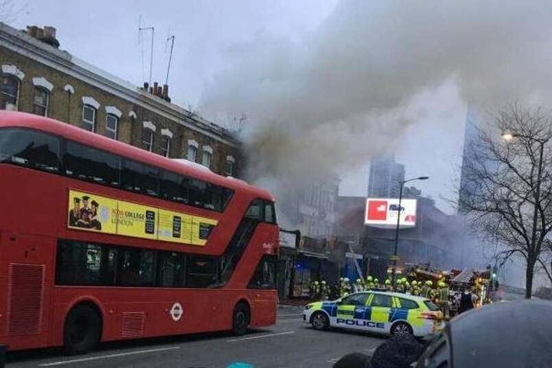
Smoke billows out of the building (Photo: @drbenjohnson)
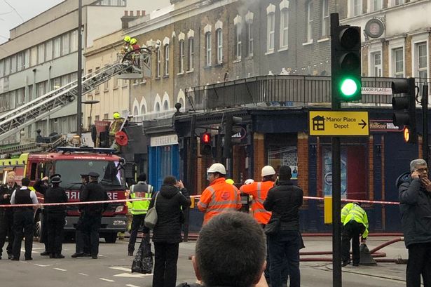
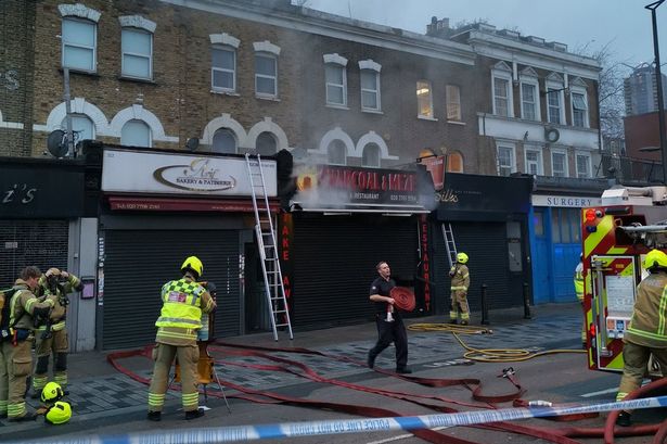
Building History
(Researched by Heritage & Ecclesiastical Fire Protection)
(Researched by Heritage & Ecclesiastical Fire Protection)
The terraced row of buildings that can be seen on the pictures above - (206-222 (evens) Walworth Road) - is Locally Listed and lies within the Walworth Road Conservation Area. This group of late Victorian properties (c. 1876) form a cohesive group. The buildings have a number of surviving shop front elements, including corbels and pilasters. At first floor level the group have semicircular brick arched windows with keystones and the slender recessed arched detail separates each house. No. 206 also retains an original timber and glazed shop front. The run is completed by the former King’s Head Public House, No. 204 Walworth Road, which is located at the junction with Manor Place. Like with so many of the other purpose built public houses in the conservation area, the King’s Head replaced an earlier building. The current building was constructed between c. 1860-80. It is a 3 storey stock brick Italianate building, with pedimented palazzo style windows and stucco window surrounds at second floor level. Despite no longer in use as public house the frontage has been retained, the brown glazed tiles incorporating curved window sills and the original window frames with curved corner detailing still exist. On Manor Place, the two storey extension and the archway into the former stable yard at the rear, now form part of a separate doctor’s surgery.
The whole area of Walworth Road has recently been designated by Historic England as one of 18, (soon to be 20), Heritage Action Zones (HAZ) throughout England.
Walworth has been in existence as a manor and parish since Anglo-Saxon times. The Walworth Road tells the story of the development from a medieval hamlet to a dense inner-city neighbourhood through late 18th century gentrification to become an area of industry and dense working class housing in the 19th and 20th centuries.
Alongside surviving fragments of Georgian building are elements and traces of the notable pleasure gardens, productive orchards and flower nurseries which once surrounded Walworth's town centre and the Walworth Road. During the 18th and 19th centuries Walworth Road developed as the principal trading street, encompassing East Street Market, considered to be one of the oldest trading markets in London and has existed in various iterations since the 16th century.
Once an important civic centre, Walworth lies on a busy arterial road, which, with the demise of its railway station has seen an erosion of character and significance. The area also suffers from high levels of social deprivation, with vacant properties and deteriorating retail units.
Walworth has great potential to reconnect to its heritage and use this to underpin a sense of identity and support the social, economic and environmental needs of the area. The HAZ will unlock the significance of Walworth's heritage, restore vacant properties, deliver new housing and re-establish this intriguing urban village as a place where people want to live, work and explore.
The main aims of the HAZ are:
- To use Walworth's heritage assets as a catalyst for economic growth, delivering the distinctive identity and social vitality of this London village
- Ensure effective management of heritage assets, putting heritage at the heart of delivering sustainable growth
- To galvanise a robust partnership and secure commitment from all stakeholders to champion the special character of the area
- To raise understanding of the value and role of historic character as a key asset by developing innovative ways and opportunities for residents and businesses to engage with heritage.
- To strengthen community awareness and support activities and participation in programmes which underpin well-being, interest and further engagement within the area.
|
|
Near Miss
15 January 2019 (19:30) - Fire started deliberately at home of Only Fools and Horses star John Challis
15 January 2019 (19:30) - Fire started deliberately at home of Only Fools and Horses star John Challis
The fire which came close to setting fire to the mansion owned by Only Fools and Horses and Benidorm actor John Challis was started deliberately. Arsonists torched the barn which was tackled by 60 firefighters. They were called to a blazing barn in Leintwardine at 7.30pm on the 15th. The blaze was contained to the barn and did not spread to Wigmore Abbey, thanks to the work of the firefighters.
A spokesperson for Hereford and Worcester Fire and Rescue Service said: "On arrival, a 60m by 30m area of a barn containing straw was well alight, and crews worked to confirm no people were inside, and to stop it spreading to an adjacent property, and surrounding hedges and fields. At its height, the building was fully engulfed in fire and more than 60 fire crew, from nine fire stations across the two counties were in attendance – also assisted by colleagues from Shropshire Fire & Rescue Service and Mid and West Wales Fire & Rescue Service. Ten fire engines, breathing apparatus, and a high volume water pump, were used to bring the fire under control. Firefighters remained on site for more than 24 hours to dampen down and ensure the fire was fully extinguished before the incident was closed. The HWFRS Fire Investigation team worked with West Mercia Police and identified the cause of the fire was deliberate.The matter is now under police investigation."
Actor John Challis – best known for playing Boycie in TV's Only Fools and Horses – lives in the area. He said on Twitter: "Drama at Wigmore Towers! Massive fire broke out in a barn on the other side of the lane. Pottering in the greenhouse when I heard bangs and explosions, looked up and there’s flames and smoke. Rushed over and it was well away so phoned 999." He later visited the scene and said on Twitter: "The fire engines are STILL here 24 hours later keeping an eye on the still-smouldering pile of pooh. Hah!" Later he said: "Depressing start to the year but luckily no livestock in there. Machinery, fertiliser and straw all destroyed and barn gone! Asbestos roof so masks all round and six fire engines! Still smoking now." Challis released a book, Wigmore Abbey: The Treasure of Mortimer, in 2016 about the history of the property and the restoration efforts. The abbey was used as the set for the Only Fools and Horses spin-off - The Green, Green Grass.
Challis and his wife, Carol, bought Grade I listed Wigmore Abbey in 1998 and the duo have worked on restoring the only remaining habitable part of the property, the Abbot’s Lodging, over the past 20 years. It was a functioning Augustinian Abbey between 1179 and 1530, when it was razed during Henry VIII's wide scale destruction of Catholic monasteries. The ruin of the abbey church is a Scheduled Ancient Monument.
Source: Gloucestershie Live
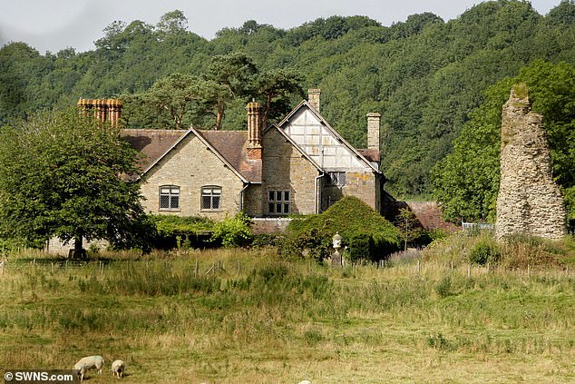
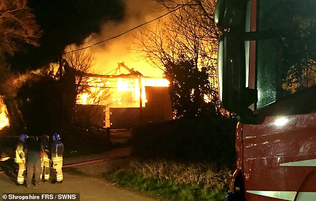
Listing Details
|
Entry Name: Remains of Wigmore Abbey
Listing Date: 11 June 1959 Grade: I Source: Historic England Source ID: 1179921 English Heritage Legacy ID: 149486 Location: Adforton, County of Herefordshire, SY7 County: County of Herefordshire Civil Parish: Adforton Traditional County: Herefordshire Lieutenancy Area (Ceremonial County): Herefordshire Church of England Parish: Wigmore Abbey Church of England Diocese: Hereford |
Coordinates
Latitude: 52.3367 / 52°20'12"N Longitude: -2.8663 / 2°51'58"W OS Eastings: 341067 OS Northings: 271308 OS Grid: SO410713 Mapcode National: GBR BC.TYVK Mapcode Global: VH76S.8JJK |
14 January 2019 (08:00) Suspected arson at historic Ripon building
A fire which broke out at Ripon’s former Cathedral Choir School site is ‘believed to have been caused deliberately’. North Yorkshire Fire and Rescue Service and North Yorkshire Police are investigating after being called to the incident on Whitcliffe Lane at 8am on Monday. A NYFRS spokesperson said: “The fire involved floorboards and joists and caused fire, heat and smoke damage to the room of origin, with some smoke damage to the rest of the building.” Neighbourhood Policing for Ripon, Pete Macmillan, said the fire is being treated as arson due to the scale of the damage. The fire was extinguished using two hose reel jets, eight breathing apparatus, two thermal imaging cameras, three saws, two hooligan tools and two triple extension ladders. Firefighters were on the scene for more than two and a half hours.
Ripon Cathedral Choir School closed at short notice in 2012, after proposals for a merger with a neighbouring independent school collapsed. Governors had hoped that the proposal to amalgamate it with Cundall Manor School, eight miles away, at Thirsk, would solve their financial problems, which include debts of £600,000 - much of it owed to the cathedral.
This is not the first time that the choir school building has been targeted by arsonists - in April last year, another fire caused damage to one of the classrooms, which prompted wider concerns about the vulnerability of empty historic buildings in the city. Reacting to the news of the fire this week, the Chairman of Ripon Civic Society, Chris Hughes, said: “Ripon Civic Society will do what it can to keep historic buildings at risk under scrutiny and will press for action where neglect is likely to turn into damage and ultimate loss. Anyone who has any information about the fire should call 101, quoting log 80.
Although this is not a listed building it is nonetheless a heritage asset. The front elevation of the school building was the originally the rear in its former use as the old racecourse grandstand. In 1865, what was then called the “new racecourse,” was opened off Whitcliffe Lane at Redbank. It remained there for over forty years. Afterwards, it became St Olave's Preparatory School, and then the Cathedral Choir School in 1960.
Source: Yorkshire Post
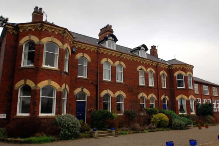
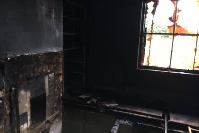
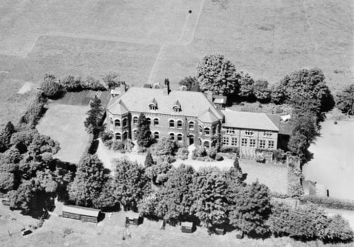
St Olave's Preparatory School, Ripon, 1949 (Image: Historic England)
14 January 2019 (17:30) - Fire service called to high street pet shop
Fire fighters have been called to a high street pet shop. Two Norfolk Fire and Rescue Service pumps from Diss and Eye arrived at Myhill’s Pet and Garden shop on Mere Street in Diss shortly before 5.30pm. Roger Mitchell, Southern District station manager, said: “All that happened was there was a tiny overheat in the electrical box. Obviously quick action by the shop to get people out of the site and letting us know as soon as they can is always appreciated.” Jules Leeder, a Myhill’s regular customer from Long Meadow Drive, said: “I thought I smelt a bit of burning coming from the shop, and Odi my dog smelt it too.”
The Pet Shop is at number 35 Mere Street, and together with adjoining 33 and 34 they are
Grade II listed as a group. Built in the early 19th century, they form an unusual composition of great interest. The centre house with has an octagonal attic.
Source: Eastern Daily Press
The Pet Shop is at number 35 Mere Street, and together with adjoining 33 and 34 they are
Grade II listed as a group. Built in the early 19th century, they form an unusual composition of great interest. The centre house with has an octagonal attic.
Source: Eastern Daily Press
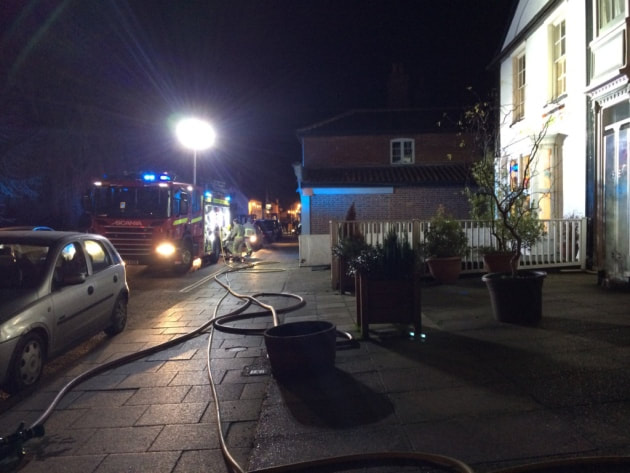
Listing Details
|
Entry Name: 33-35, Mere Street
Listing Date: 8 June 1972 Grade: II Source: Historic England Source ID: 1049749 English Heritage Legacy ID: 224835 Location: Diss, South Norfolk, Norfolk, IP22 County: Norfolk District: South Norfolk Civil Parish: Diss Built-Up Area: Diss Traditional County: Norfolk Lieutenancy Area (Ceremonial County): Norfolk Church of England Parish: Diss St Mary Church of England Diocese: Norwich |
Coordinates
Latitude: 52.3744 / 52°22'27"N Longitude: 1.1092 / 1°6'33"E OS Eastings: 611738 OS Northings: 279702 OS Grid: TM117797 Mapcode National: GBR THY.577 Mapcode Global: VHL97.5LR4 |
13 January 2019 (19:16) - Fire breaks out under Gloucestershire hairdressers
Emergency services were called this evening (13th) to a fire in a Cheltenham town centre flat. A woman was rescued from the fire and taken to Southmead Hospital with serious burns. A Gloucestershire police spokesman said at around 8.45pm: "We were called by Gloucestershire Fire and Rescue Service to a flat fire in Grosvenor Place South in Cheltenham shortly after 7.30pm. A woman has been rescued from a fire and is receiving treatment from the ambulance service. The fire has now been extinguished and the fire service is working to identify the cause. Members of the public are asked to avoid Grosvenor Place South and Albion Street."
A spokesman for Gloucestershire Fire and Rescue Service said, "The cause of the fire is subject to ongoing investigation.” South Western Ambulance Service said it responded with the Hazardous Area Response Team (HART), who are specially trained to work in conditions such as fire and water rescue. It also sent three ambulances and the critical care team and said one patient was taken to Southmead Hospital with serious burns. It is understood the woman was the only person in the flat when the fire broke out.
The premises is part of a building of three terraced properties, known as Aldridge House, which is Grade II listed and is within the Central Conservation Area. It was built in the early 19th century and consists of 2 storeys with attics and basement.
Source: Gloucestershire Live
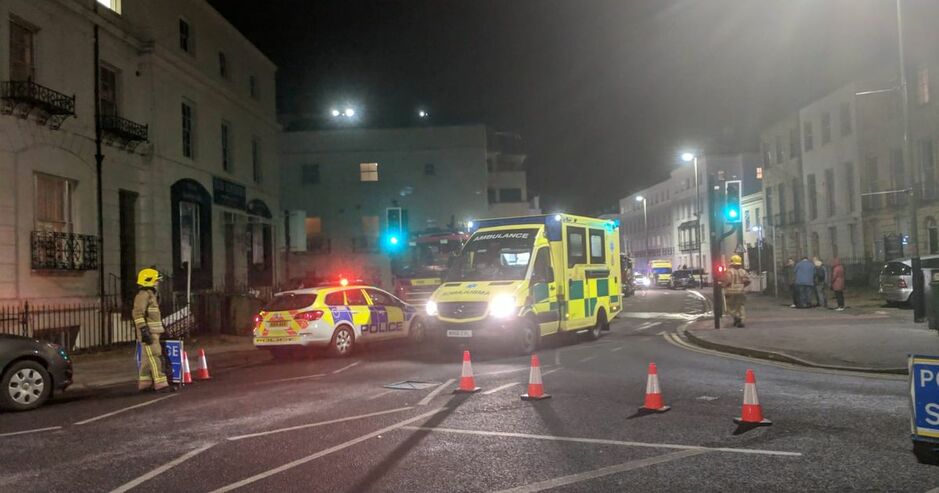
Emergency services in Cheltenham town centre at the scene of the fire (building on left of picture)
Listing Details
|
Entry Name: Aldridge House (Number 79) and Attached Railings to Number 77 number 11 and Attached Railings
Listing Date: 12 March 1955 Grade: II Source: Historic England Source ID: 1386676 English Heritage Legacy ID: 474072 Location: Cheltenham, Gloucestershire, GL52 County: Gloucestershire District: Cheltenham Town: Cheltenham Electoral Ward/Division: All Saints Built-Up Area: Cheltenham Traditional County: Gloucestershire Lieutenancy Area (Ceremonial County): Gloucestershire Church of England Parish: Cheltenham All Saints (Pittville) Church of England Diocese: Gloucester |
Coordinates
Latitude: 51.9001 / 51°54'0"N Longitude: -2.0705 / 2°4'13"W OS Eastings: 395245 OS Northings: 222400 OS Grid: SO952224 Mapcode National: GBR 2M4.Z6S Mapcode Global: VHB1Q.2H8Q |
13 January 2019 (18:30) - Firefighters battle 'six-foot' flames in 'severe' Southville house fire
Firefighters from across the city rushed to Southville after a 'six-foot' blaze broke out in a house. Avon Fire and Rescue Service engines from Bedminster, Temple, Kingswood, Southmead and Avonmouth fire stations converged on Coronation Road at about 6.30pm this evening (January 13). A blaze - believed to be an electrical fire - had broken out in one of the bedrooms and the flames had grown to be six feet tall, according to a resident. Officers from Avon and Somerset Police closed the road while the fire service battled to bring the flames under control.
One of the occupants of the house said: “There was an electrical fire in one of the bedrooms. I was in the room above doing some decorating. I heard some crackling and smelt some smoke. Went downstairs, opened the door, there’s a large six-foot fire in there. Then I ran downstairs, got everyone else out the house, called the fire brigade. Me and my brother went back in to see if we could extinguish the fire, walked back in, saw that it was thick smoke and was down to the floor, and then we saw it was an electrical fire. My brother tried putting it out with water but obviously that didn’t work. We had nothing to smother it with so we just had to leave. No injuries luckily. It started at about 6.30pm. It was above my room so that’s all my stuff burning down. Took the fire service about five to 10 minutes to get here.
At 19.45 A spokesman for Avon Fire and Rescue Service said: We were called to Coronation Road at 6pm. On arrival, crews were met with a fully-developed, severe fire in a three-storey terraced property. They quickly requested six engines and one turntable ladder. Crews fought the fire using eight breathing apparatus, three high-pressure hose reels, two 45mm jets and the turntable ladder. Through the hard work of the crews in difficult circumstances, they were able to contain the fire within the original property and prevent any spread to the neighbouring terraced dwellings.
Source: Bristol Live
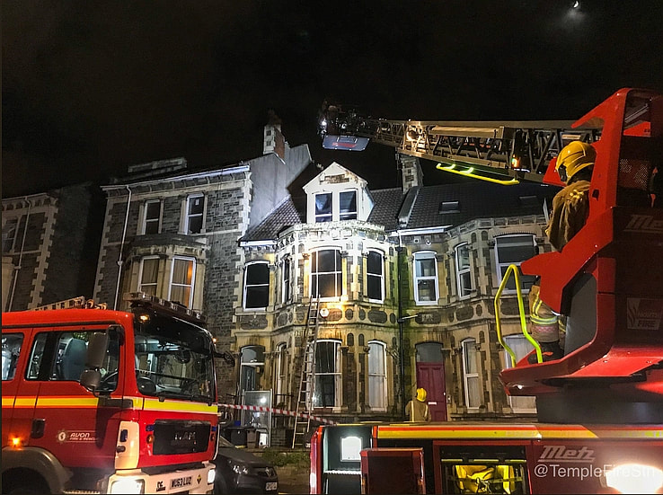
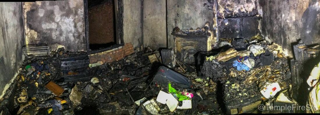
Coronation Road Character Area is part of Bedminster Conservation Area. It is a street of diverse architecture, from the grand Georgian terraces that date from the early 19th century up to the late Victorian/Edwardian era. 136 Coronation Road, where the fire happened, is described as a “Character Building”.
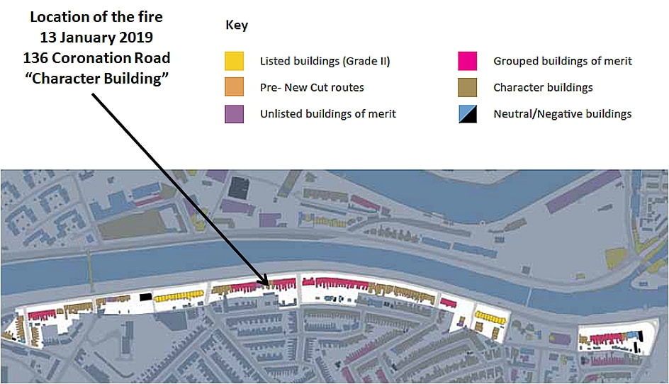
13 January 2019 (04:40) - Several fire crews called to tackle fire at Greggs bakery in Bath
Firefighters were called to a Greggs bakery in the centre of Bath in the early hours of Sunday morning as the shop was engulfed in flames. Three fire crews from Bath and specialist equipment from Temple Fire Station raced out to Westgate Street at around 4.45am as the Greggs there was on fire. Brock Cockner witnessed the 'big fire' at the scene. Brock was on a night time stroll as he could not sleep when he spotted the flames. At the time he said: "I walked past and something exploded out at me." He later added: "I have just witnessed a big fire at the Greggs on Westgate street, Bath. The fire started at roughly 4:40 am, just as I walked past. It looked like one of the coolers for sandwiches was what started the fire. I immediately called the fire brigade. I went to see if anyone was inside, at a safe distance, and a guy came outside and said nobody else was indoors. I stood back and watched it unfold. As the fire started getting bigger, elements inside the fridge unit started exploding. There were lots of really intense explosions. Quite a few drunk people were close. I kept telling them to stand back as it was really dangerous. The wait for the fire crews felt a lot longer than five minutes. But time moves slower in these situations. They put it out within a minute or so and did a fantastic job.”
On arrival, the crews found that the ground floor was full of smoke. The crews, who used two breathing apparatus in the operation, used two 45mm jets and one hose reel jet to put out the fire. One person in the flat above was led to safety and handed over to the ambulance service. Following investigations, the fire was found to be accidental.
Greggs occupies No 8 Westgate Street which is in a row of three terraced, early 19th century buildings, Grade II listed as a group. The building lies within the Bath Conservation Area.
Source: Somerset Live
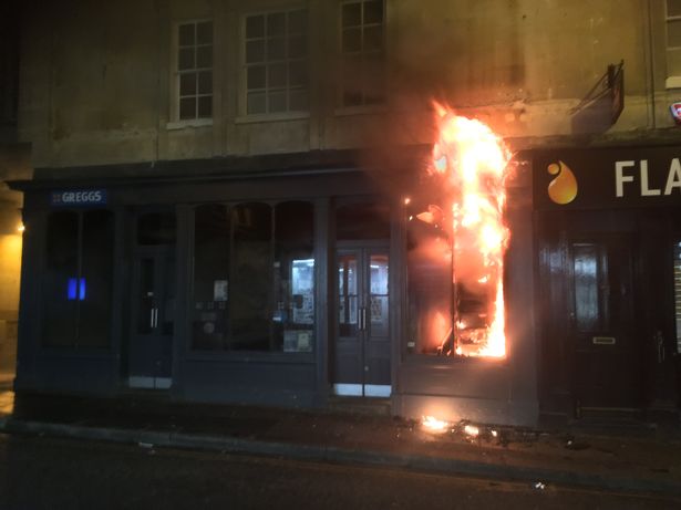
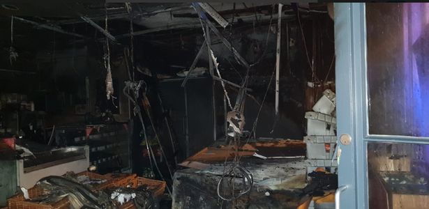
Listing Details
|
Entry Name: 8, 9 and 10, Westgate Street
Listing Date: 5 August 1975 Last Amended: 15 October 2010 Grade: II Source: Historic England Source ID: English Heritage Legacy ID: 511050 Location: Bath and North East Somerset, BA1 County: Bath and North East Somerset Electoral Ward/Division: Abbey Built-Up Area: Bath Traditional County: Somerset Lieutenancy Area (Ceremonial County): Somerset |
Coordinates
Latitude: 51.3814 / 51°22'52"N Longitude: -2.3611 / 2°21'39"W OS Eastings: 374966 OS Northings: 164765 OS Grid: ST749647 Mapcode National: GBR 0QH.9W3 Mapcode Global: VH96M.1J4W |
Near Miss
13 January 2019 (00:20) - Petrol bombs thrown at nightclub during night of violence in Birmingham
13 January 2019 (00:20) - Petrol bombs thrown at nightclub during night of violence in Birmingham
Petrol bombs were thrown at a Birmingham nightclub in the early hours of this morning as thousands of people enjoyed a night out. Police are hunting two men who pulled up outside Zara’s bar in Broad Street at around 12.20am and threw two bombs while shouting racist abuse. The crude bombs were made in bottles and they missed their target landing on the pavement without injuring anyone. Inspector Noeleen Murrin told Birmingham Live: ‘We believe this to be an isolated incident, and are working to understand the motive behind it. The investigation is progressing and witnesses are being spoken to. We’re speaking to other venues in the area to offer reassurance.’ Officers are currently trawling through CCTV footage of Broad Street in the hope of identifying the culprits.
The building dates back to 1814 and is Grade II listed (see Building History, below)
News Source: Metro
Update 12 February 2019 - Birmingham's Broad Street venue Zara's Bar has had its alcohol licence permanently revoked after it was targeted by fire bombs. Officials at West Midlands Police stated they could no longer trust the premises after staff lied to them about violence which flared around 11pm on Saturday, January 12, which the force believe ultimately provoked the attack around an hour later . Birmingham City Council had previously suspended the licence in the wake of the incident and rejected two applications by the venue to lift the ban.
Listing Details
|
Entry Name: Main Block to the Royal Orthopaedic Hospital
Listing Date: 8 July 1982 Grade: II Source: Historic England Source ID: 1075733 English Heritage Legacy ID: 216825 Location: Birmingham, B15 County: Birmingham Electoral Ward/Division: Ladywood Built-Up Area: Birmingham Traditional County: Warwickshire Lieutenancy Area (Ceremonial County): West Midlands Church of England Parish: Ladywood Church of England Diocese: Birmingham |
Coordinates
Latitude: 52.4756 / 52°28'32"N Longitude: -1.9143 / 1°54'51"W OS Eastings: 405916 OS Northings: 286408 OS Grid: SP059864 Mapcode National: GBR 5XB.6G Mapcode Global: VH9Z2.R1VK |
Building History
(Researched by Heritage & Ecclesiastical Fire Protection)
Built in 1814 as Islington House for Rice Harris, the owner of the Islington Glass Works, which lay behind the house. The house became the Lying-in Hospital in 1842 set up to provide maternity care for the poor. From 1870 it was the Birmingham & Midland Free Hospital for Sick Children which had originally been founded in Steelhouse Lane in 1861.
In the 23rd May edition of The British Journal of Nursing, an article on the hospital said the following:
“The Birmingham and Midland Free Hospital for Sick Children, which has its in-patient department of 62 beds in Broad Street and a large out-patient department in Steelhouse Lane, has for over 50 years served the children of the city well. But the work has now outgrown the possibilities of the institution, and before very long this familiar landmark standing well back from the road, with a broad carriage sweep in front, and the faces of little children peeping from the wide-open windows, as they lie in cots arranged that they may obtain as much of the fresh air as possible will be a thing of the past, for a fine new hospital, built as a memorial to the late King, by popular subscription, is rapidly approaching completion in Ladywood Road, and it is anticipated that the opening ceremony will take place next year. The foundation-stone was laid in April of last year by H.R.H. Princess Louise, Duchess of Argyll, who was accompanied by the late Duke.
The Matron of the hospital is Miss M. Fison Clarke. The term of training of probationers is for three years; ordinary probationers receive a salary of £9, £11 and £14 respectively. If, by mutual agreement, the probationer stays for a fourth year, she is paid at the rate of £20. A certain number of special probationers are received between the ages of 20 and 26. At the end of the first year they can, with the approval of the Matron, continue their work at the same salary as the regular probationers. Many nurses begin their training in a children’s.hospita1, when too young for general work, and then pass on to a general hospital, a comprehensive training which makes them exceedingly valuable workers later on. The Nurses’ Home is apart from the hospital, and in the intervening space children can lie out in the fresh air under cover.”
The children’s hospital moved to its new building in 1917 and the Broad Street building became the Royal Cripples Hospital, before being renamed the more acceptable Royal Orthopaedic Hospital until its closure in 1985. The building became the Old Orleans bar and restaurant from about 2000 until it closed in 2011.
It then became Zara's bar, opening on the 12th September 2015 . Business owner, Pete Sangha, was involved in action taken by The Victorian Society after he put up a huge smoking canopy and garish silver and red signs outside the Grade II listed building, prior to it opening. The council took enforcement action to remove the 24ft canopy but Mr Sangha put it up again and bolted numerous blazing red signs on to the front. Recently, Mr Sangha has added two large stone lions and TV screens outside the venue, which are not subject to the original enforcement notice, Stephen Hartland, chair of the West Midlands Victorian Society, said although the lions were a matter of “taste” he renewed his plea for Mr Sangha to act within the law. He said: “This heritage asset has been assessed and designated as a building of special architectural or historic interest. The signage and the canopy did not have listed building consent and when Mr Sangha applied for it, he was refused.” The canopy still remains in place.
10 January 2019 (16:21) - Fire at Almondbury beauty clinic
There has been a building fire in Almondbury. Firefighters from Huddersfield and Dewsbury Fire Stations were been scrambled to St Helen's Gate, at the junction with Fenay Lane and Westgate. Emergency crews were called to Features Beauty Clinic, based in a Grade II listed Georgian building and lies within the Almondbury Conservation Area. The business, which was established in 1987, offers a wide range of salon and spa treatments.
West Yorkshire Fire and Rescue Service said the call came in at 4.21pm and firefighters discovered that 30% of the building's roof space was "involved in the fire". Three fire appliances and a hydraulic platform were used to douse the flames from above. The main road was closed at rush-hour at the junction of Northgate, Southgate and Fenay Lane, causing some disruption to traffic. It is understood the salon was open at the time but that no-one was hurt. At this stage it is not known how the fire started.
Source: Examiner Live
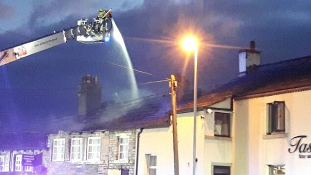
Firefighters tackle a fire at Features Beauty Clinic in Almondbury (Picture: Brian Ruttle)
Listing Details
|
Entry Name: 3 and 5, St Helens Gate
Listing Date: 29 September 1978 Grade: II Source: Historic England Source ID: 1232162 English Heritage Legacy ID: 407020 Location: Kirklees, HD5 County: Kirklees Electoral Ward/Division: Almondbury Built-Up Area: Huddersfield Traditional County: Yorkshire Lieutenancy Area (Ceremonial County): West Yorkshire Church of England Parish: Almondbury with Farnley Tyas Team Parish Church of England Diocese: Leeds |
Coordinates
Latitude: 53.6314 / 53°37'52"N Longitude: -1.7461 / 1°44'45"W OS Eastings: 416886 OS Northings: 415011 OS Grid: SE168150 Mapcode National: GBR JV7F.RZ Mapcode Global: WHCB2.4ZSJ |
10 January 2019 (15:30) - A former Castlefield pub went up in flames
A derelict pub in Castlefield went up in flames for the second time in a year. Firefighters were called to the former Commercial Hotel, on Woollam Place, off Liverpool Road, at 3.30pm on Thursday. Images taken from the scene show smoke pouring out of the windows of the dilapidated building. The building has been used by rough sleepers in recent months. A section of the road was sealed off while crews dealt with the incident. The cause of the fire is being investigated. Firefighters were also called to the building on the 22nd January last year.
A spokesman for Greater Manchester Fire and Rescue Service said: "Firefighters used four breathing apparatus and two hose reels to tackle the fire. They used a positive pressure ventilation fan to clear smoke from the building. There were three engines from Manchester central, Moss Side and Salford. There were no injuries or anyone in the building."
The Commercial Hotel, which sits in the Castlefield Conservation Area, is Grade II listed and dates from the mid-19th century. There have been two planning applications to convert the Commercial Hotel and an adjoining Grade II listed building into a 39-room boutique hotel. The first was in 2011, but expired without any works taking place. The second was in 2017, but there has still been no progress.
Source: Manchester Evening News
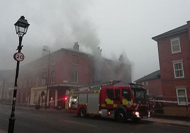
Firefighters have tackled a blaze at a former pub in Castlefield. (Image: Zoe Bartlett)
Listing Details
|
Entry Name: Former Commercial Hotel
Listing Date: 6 June 1994 Grade: II Source: Historic England Source ID: 1219418 English Heritage Legacy ID: 388275 Location: Manchester, M3 County: Manchester Electoral Ward/Division: City Centre Built-Up Area: Manchester Traditional County: Lancashire Lieutenancy Area (Ceremonial County): Greater Manchester Church of England Parish: Manchester St Ann Church of England Diocese: Manchester |
Coordinates
Latitude: 53.4769 / 53°28'36"N Longitude: -2.2579 / 2°15'28"W OS Eastings: 382982 OS Northings: 397827 OS Grid: SJ829978 Mapcode National: GBR DFJ.SM Mapcode Global: WHB9G.9V2X |
10 January 2019 (04:42) - Fire at The Two Brewers in Ongar was arson
Police have cordoned off a pub in Ongar following an arson attack in the early hours of this morning (Thursday, January 10). Emergency services attended the scene after receiving reports of a fire at The Two Brewers in Greested Road. Fire crews rescued one person from the pub and were able to extinguish the blaze by 4.42am. Extensive damage has been caused to the building's ground floor. Fortunately, one was injured during the incident.
An investigation has been launched into the cause of the fire and the scene has been taped off. One witness, who asked not to be named, said: "Police are there and all the windows are open." Essex Police are appealing for information about the incident, particularly from anyone who saw a silver vehicle leaving the area.
The Two Brewers is a beautiful old, oak beamed, Grade II listed building dating back to 1791.
Source: Essex Live
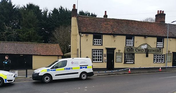
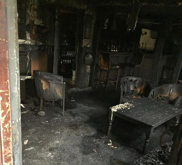
Listing Details
|
Entry Name: Two Brewers Public House
Listing Date: 11 April 1984 Grade: II Source: Historic England Source ID: 1337519 English Heritage Legacy ID: 117872 Location: Ongar, Epping Forest, Essex, CM5 County: Essex District: Epping Forest Civil Parish: Ongar Built-Up Area: Chipping Ongar Traditional County: Essex Lieutenancy Area (Ceremonial County): Essex Church of England Parish: High Ongar St Mary the Virgin with Norton Mandeville All Saints Church of England Diocese: Chelmsford |
Coordinates
Latitude: 51.7004 / 51°42'1"N Longitude: 0.2422 / 0°14'31"E OS Eastings: 555043 OS Northings: 202565 OS Grid: TL550025 Mapcode National: GBR MGZ.81Y Mapcode Global: VHHMP.4JW9 |
9 January 2019 (23:05) Quick thinking landlord saves pub from suspected arson attack
The Kings Arms landlord saw smoke coming from the door and two window seals at the front of the pub and on one of them he says he found a plastic bottle wrapped in a rag on fire.
A quick thinking pub landlord has spoken of how an arsonist attempted to set fire to his pub at closing time but he was able to extinguish the flames by the time fire crews arrived. James Kirkness, of the 18th Century Grade II listed The Kings Arms in Ottery St Mary, was letting the last customers out of his pub on Wednesday when he spotted flames at the front door and on two window sills.He evacuated the building and tackled the flames with a fire extinguisher before the flames had spread, and then called the fire brigade. By the time they arrived the fire was out and there was only minor damage to the pub, including to a window which has since been replaced.
James said: "It happened when the pub was shut at 11.05pm. I had four customers who were proceeding to leave when I went to the front door and could see amber lights on the corner of the door. At first I assumed it was a gritter coming down the hill but then I got a strong smell of accelerant from under door and realised it was on fire. I evacuated the building and then put out the fire at the door." James then realised smoke was also coming from two window seals at the front of the pub and on one of them he says he found a plastic bottle wrapped in a rag on fire which was where most of the damage was sustained. He said: "I put it out and the remaining fire. There was light damage to the door and smoke damage to the window and all where the fire had gone out. The fire alarms had gone off." At 11.10pm James says he called the fire brigade who inspected the building and reported no further problems and confirmed the fire was out.
James said: "It seems someone poured accelerant under the front door, on the door and also on the two window seals. It's business as usual; we won't let those people stop us." Police are investigating the incident and are appealing for any witnesses to come forward.
Source: Devon Live
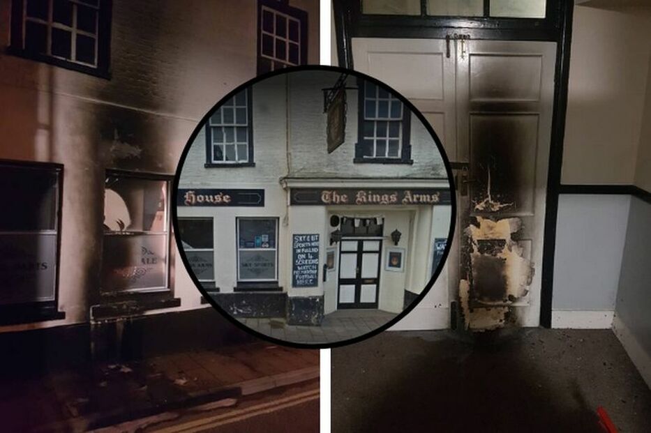
Fire damage at The Kings Arms in Ottery St Mary (Image: James Kirkness)
Listing Details
|
Name: Kings Arms
Listing Date: 28 April 1952 Last Amended: 11 January 1974 Grade: II Source: Historic England Source ID: 1213195 English Heritage Legacy ID: 397643 Location: Ottery St. Mary, East Devon, Devon, EX11 County: Devon District: East Devon Civil Parish: Ottery St. Mary Built-Up Area: Ottery St Mary Traditional County: Devon Lieutenancy Area (Ceremonial County): Devon Church of England Parish: Ottery St Mary Church of England Diocese: ExeterEntry |
Coordinates
Latitude: 50.752 / 50°45'7"N Longitude: -3.2781 / 3°16'41"W OS Eastings: 309931 OS Northings: 95486 OS Grid: SY099954 Mapcode National: GBR P7.M2B4 Mapcode Global: FRA 4703.4QW |
9 January 2019 (12:45) – Firefighters tackle chimney fire in Eton Pub
Firefighters tackled a chimney fire at a pub in Eton today (Wednesday). When the three crews from Slough, Langley and Windsor arrived at the Grade II listed The George Inn, High Street, at about 12.45pm, flames were coming out of the top of the chimney. They spent two hours bringing the flames under control and managed to contain the damage to the chimney.
The George Inn lies within the Eton Conservation Area.
Source: Windsor Express
The George Inn lies within the Eton Conservation Area.
Source: Windsor Express
The George Inn, Eton, Windsor
Listing Details
|
Entry Name: The George Inn
Listing Date: 14 May 1973 Grade: II Source: Historic England Source ID: 1290039 English Heritage Legacy ID: 395846 Location: Eton, Windsor and Maidenhead, SL4 County: Windsor and Maidenhead Civil Parish: Eton Built-Up Area: Windsor Traditional County: Buckinghamshire Lieutenancy Area (Ceremonial County): Berkshire Church of England Parish: Eton Church of England Diocese: Oxford |
Coordinates
Latitude: 51.4864 / 51°29'11"N Longitude: -0.6089 / 0°36'31"W OS Eastings: 496686 OS Northings: 177300 OS Grid: SU966773 Mapcode National: GBR F8D.NW9 Mapcode Global: VHFT8.DWGX |
Building History
(Researched by Heritage & Ecclesiastical Fire Protection)
The George Inn is situated just across the bridge from Windsor, in the town of Eton. It is a traditional Georgian building, built around 1750, of traditional construction having solid brickwork to the external walls, solid concrete cellar floor, timber framed ground, first and second floors and a pitched tiled roof. There have been modifications to the High Street facing side of the building in the 19th century. The long and narrow High Street, on which The George stands, and round which the town of Eton is built, formed part of the main road from London to Windsor for nearly 800 years. It is possible that The George was built on the site of a former Tavern, also known as The George, as it is mentioned in a catalogue of 1636 compiled by John Taylor, a waterman of London.
9 January 2019 (08:30*)- Firefighters tackle blaze that took hold in pub Chimney
Chipping Sodbury was at a standstill, for a short amount of time, as firefighters took on a fire in the chimney of a much-loved pub. Crews from Yate and Bath Fire Station attended the incident at the Royal Oak pub on the High Street on Wednesday. On Twitter, Yate Fire Station said: "'Yate on Call' Worked with Yate's whole time and Bath's turntable ladder crews when we were called to a chimney fire in Chipping Sodbury. After some investigation the fire was extinguished with specialist equipment. Remember to get your Chimney Swept regularly."
The pub itself posted on their own Facebook page confirming nobody was injured in the incident. "A slight fire in the chimney today," they said. "No one is injured, we're open as normal and serving a selection of smoked meat dishes this evening. Our huge thanks to Avon Fire and Rescue. Exceptionally professional group and really nice set of lads."
The Royal Oak is a late 16th / early 17th century coaching house inn, it is Grade II listed and lies within the Chipping Sodbury Conservation Area.
Source: Gazette
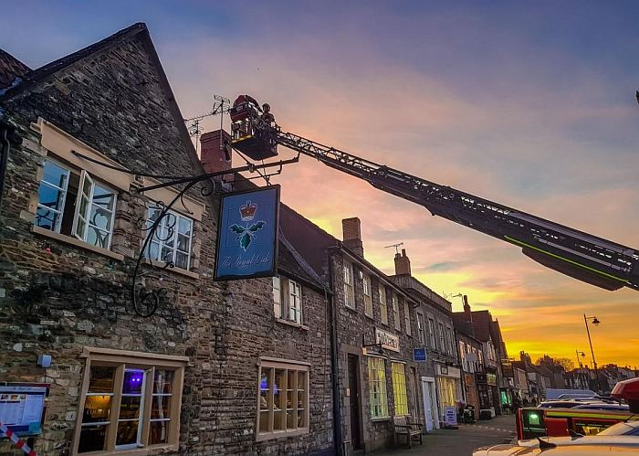
Chimney fire at the Royal Oak
Listing Details
|
Entry Name: Royal Oak Public House
Listing Date: 29 July 1983 Grade: II Source: Historic England Source ID: 1129251 English Heritage Legacy ID: 34081 Location: Sodbury, South Gloucestershire, BS37 County: South Gloucestershire Civil Parish: Sodbury Built-Up Area: Chipping Sodbury Traditional County: Gloucestershire Lieutenancy Area (Ceremonial County): Gloucestershire Church of England Parish: Chipping Sodbury St John the Baptist Church of England Diocese: Gloucester |
Coordinates
Latitude: 51.5381 / 51°32'17"N Longitude: -2.3921 / 2°23'31"W OS Eastings: 372901 OS Northings: 182206 OS Grid: ST729822 Mapcode National: GBR 0NJ.G1T Mapcode Global: VH95T.HL7R |
9 January 2019 (08:21) - Around 45 firefighters called to cottage fire in Church Lane, Ripple
Emergency services are at the scene of a fire at a Grade II listed cottage. Around 45 firefighters, eight fire engines and a water carrier were sent to Church Lane in Ripple, near Deal, at 8.21am. Police are assisting the fire service and working to establish the cause of the blaze.All people in the home have been accounted for and there are no reported injuries. Crews entered wearing breathing apparatus and put the fire out which was in the basement.
The fire was in a thatched cottage, although the fire did not affect the thatch. Firefighters are urging anyone with a thatched cottage is encouraged to visit Kent Fire and Rescue Service's website to find out how to protect their homes. Church Lane is a narrow single track road. A van parked near to the church made access difficult for the appliances to access the property. It prompted a reminder to motorists to park considerately, ensuring that an emergency vehicle could pass if needed.
The fire was at the property named Raspberry Cottage, although it was previously called Stanley Cottage. It dates from the early 18th century, or earlier, as the origins of the building are said to go back to 1564. The cottage is currently used as a holiday let.
Source: Kent Online
Listing Details
|
Entry Name: Stanley Cottage
Listing Date: 24 March 1987 Grade: II Source: Historic England Source ID: 1264332 English Heritage Legacy ID: 42818 Location: Ripple, Dover, Kent, CT14 County: Kent District: Dover Civil Parish: Ripple Traditional County: Kent Lieutenancy Area (Ceremonial County): Kent |
Coordinates
Latitude: 51.2008 / 51°12'2"N Longitude: 1.3605 / 1°21'37"E OS Eastings: 634859 OS Northings: 149992 OS Grid: TR348499 Mapcode National: GBR X22.NSH Mapcode Global: VHLH5.J2LS |
9 January 2019 (03:07) - Police and fire crews called following disturbance at Island luxury hotel
A man has been arrested following a blaze and disturbance at a luxury hotel on the Isle of Skye in the early hours of this morning. Emergency services were called just after 3am about a fire in staff accommodation at the historic 17th century Kinloch Lodge Hotel, in Sleat on the south of the island. Police said a 25-year-old man has been charged in connection with the incident. He is expected to appear at Inverness Sheriff Court tomorrow. It is understood that a staff night out was taking place following the busy festive season. A police spokesman said: “Police Scotland can confirm that officers were called to the Kinloch Lodge Hotel on Skye shortly after 3am on Wednesday January 9 following a report of a disturbance. Partners from the Scottish Fire and Rescue Service also attended the scene to extinguish a fire within a room at the building. Nobody was injured as a result of the incident. A 25-year-old man has been charged in connection with the incident.”
Fire engines from Kyle of Lochalsh and Broadford attended and the blaze was extinguished within an hour. A spokesman for the fire service said: “The Scottish Fire and Rescue Service was alerted at 3.07am on Wednesday January 9 to reports of a fire at a hotel near A851, Isle of Skye. Operations control mobilised two fire engines and firefighters extinguished the flames. Crews left after ensuring the area was made safe.” Isabella Macdonald, owner of Kinloch Lodge, said: “In the early hours of this morning two local fire crews attended a localised fire at Kinloch Lodge. The hotel was closed for a period of refurbishment and I am incredibly relieved to say that while there were staff on site, nobody has been injured. We are very grateful to all the members of the emergency services who attended and managed to ensure the fire was brought under control quickly before any widespread damage was caused. The incident is currently being investigated by the authorities.”
Source: The Press and Journal
Building History
(Researched by Heritage & Ecclesiastical Fire Protection)
Kinloch Lodge, the home of Lord and Lady MacDonald, is an elegant white stone building situated at the head of Loch Na Dal on the Sleat Peninsula, known as the Garden of Skye. Built originally in 1680 as a farmhouse Kinloch was developed during the 18th Century as a Shooting Lodge for the Macdonalds of Skye. Godfrey Macdonald of Macdonald, Lord Macdonald and High Chief of Clan Donald, with his wife Claire established Kinloch as a small country hotel in 1973 following the death of his father. The turbulent past of the Macdonalds has led to many changes in their fortunes but one of the most important historical connections with Kinloch was the decision by Sir Alexander Macdonald not to send an army to assist Prince Charles Edward Stuart (Bonnie Prince Charlie) at Culloden in 1746 - this decision, perhaps more than any other led to the defeat of the Highland Army and thereafter the gradual demise of the Highland Clan System. Today Kinloch continues to be the home of Lord and Lady Macdonald and their four children.
8 January 2019 (21:51) - Major fire at thatched cottage in Nercwys
An historic thatched cottage was left badly damaged after a huge blaze ripped through the roof. Firefighters were called to the detached home on Ffordd Pen y Bryn in Nercwys at 9.51pm last night after the thatched roof caught fire. North Wales Fire and Rescue Service said a man in his 50s who was inside the property managed to escape as the blaze took hold. A spokesman said four fire crews attended the incident, two from Deeside, one from Mold and Buckley.
When they arrived, the thatched roof was well alight, the spokesman said. The crews used four sets of breathing apparatus and two hose reel jets to tackle the fire which was confined mainly to the thatched roof of the property. One crew remains on the scene this morning while an investigation into the cause is carried out. The spokesman added that the fire was contained to the thatched roof, with the majority of the thatch removed or damaged as a result of the fire. The road has been closed off while it is dealt with. Following the blaze, the fire service issued advice to other homeowners with thatched roofs.
Source: Leader Live
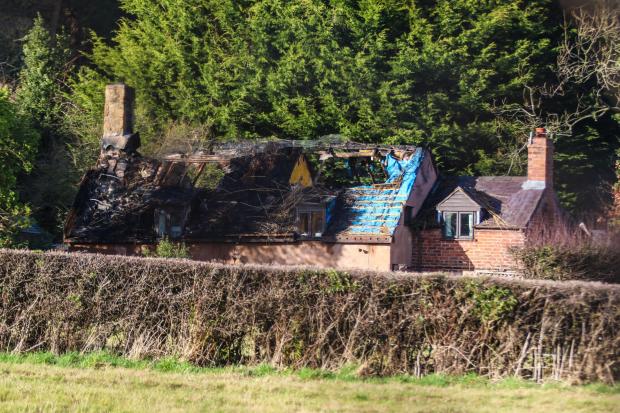
Thatched roof damaged at house in Nercwys, Flintshire. (Picture: Craig Colville)
8 January 2019 (19:10) - Fire crews called to Royal Pavilion after basement blaze
Firefighters were called to Grade I listed The Royal Pavilion after a blaze in the basement. Visitors at the ice skating rink reported a problem at 7.10pm on Tuesday this week. So a crew from Brighton and a crew from Roedean attended the scene. The crews used specialist breathing masks to stop a fire, which is believed to have spread from an electrical point inside. Flames were put out, and the crews were able to leave the scene at 7.50pm. The Royal Pavilion lies within the Valley Gardens Conservation Area.
Source: The Argus
Source: The Argus

Visitors at the ice skating rink reported a problem
Listing Details
|
Entry Name: The Royal Pavilion
Listing Date: 13 October 1952 Grade: I Source: Historic England Source ID: 1380680 English Heritage Legacy ID: 481004 Location: Brighton and Hove, BN1 County: The City of Brighton and Hove Electoral Ward/Division: St. Peter's and North Laine Built-Up Area: Brighton and Hove Traditional County: Sussex Lieutenancy Area (Ceremonial County): East Sussex Church of England Parish: Brighton The Chapel Church of England Diocese: Chichester |
Coordinates
Latitude: 50.8224 / 50°49'20"N Longitude: -0.1377 / 0°8'15"W OS Eastings: 531273 OS Northings: 104188 OS Grid: TQ312041 Mapcode National: GBR JP4.80Y Mapcode Global: FRA B6LX.Q5V |
Building History
In the mid 1780s George, Prince of Wales, rented a small lodging house overlooking a fashionable promenade in Brighton. Brighton was developing from a decayed fishing town to an established seaside retreat for the rich and famous, being close to London. It also proved popular for the therapeutic health-giving sea water remedies made famous by Dr Richard Russell, a physician from nearby Lewes. The prince had been advised by his physicians to benefit from Brighton’s fortunate climate and to try out the sea water treatments, which included ‘dipping’ (total body immersion into the salt sea water).
Brighton suited George who was a vain and extravagant man with a passion for fashion, the arts, architecture and good living. He rebelled against his strict upbringing and threw himself into a life of drinking, womanising and gambling. This decadent lifestyle combined with his love of architecture and the fine and decorative arts – his residences in London and Windsor were like immaculate sets to show off his superb collections – resulted in his incurring heavy personal debts. In 1787, after much pleading and many promises by the Prince of Wales, the House of Commons agreed to clear his debts and increase his income. George hired architect Henry Holland to transform his Brighton lodging house into a modest villa which became known as the Marine Pavilion. With his love of visual arts and fascination with the mythical orient, George set about lavishly furnishing and decorating his seaside home. He especially chose Chinese export furniture and objects, and hand-painted Chinese wallpapers. In 1808 the new stable complex was completed with an impressive lead and glass-domed roof, providing stabling for 62 horses.
In 1811 George was sworn in as Prince Regent because his father, George III, had been deemed incapable of acting as monarch. At that time the Marine Pavilion was a modest building in size, not suitable for the large social events and entertaining that George loved to host. In 1815, George commissioned John Nash to begin the transformation from modest villa into the magnificent oriental palace that we see today. This stage of the construction took a number of years. Nash superimposed a cast iron frame onto Holland’s earlier construction to support a magnificent vista of minarets, domes and pinnacles on the exterior. No expense was spared on the interior with many rooms, galleries and corridors being carefully decorated with opulent decoration and exquisite furnishings. George was determined that the palace should be the ultimate in comfort and convenience. Particular attention was paid by his architect and designers to lighting, heating and sanitation, as well as to the provision of the most modern equipment of the day for the Great Kitchen.
George became king in 1820. However, due to increased responsibilities and ill-health, once the interior of the Royal Pavilion was finally finished in 1823 he made only two further visits (in 1824 and 1827). On his death in 1830, George was succeeded by his younger brother, William IV. William IV was a popular and affable king and continued to visit Brighton and stay at the Royal Pavilion. As George IV had become reclusive towards the end of his life, the people of Brighton were reassured by William’s visibility and openness.
However, the Royal Pavilion’s accommodation was not suitable for a married sovereign and extra room had to be found for Queen Adelaide’s extensive household. Further buildings were added to the Pavilion estate, virtually all of which have since been demolished. Although William and Adelaide continued to entertain at the Royal Pavilion, it was in a much more informal style than the glamour and extravagance of former decades. King William IV died in 1837 and was succeeded on the throne by his niece Victoria. Queen Victoria made her first visit to the Royal Pavilion in 1837 and this gesture of royal approval thrilled the people of Brighton. However the lack of space in the Royal Pavilion, and its association with her extravagant and indulgent elder uncle, made Queen Victoria feel uncomfortable. She adopted a policy of financial stringency during her residence in Brighton. As her family grew and the Royal Pavilion failed to provide her with the space and privacy she needed, she finally sold her uncle’s pleasure palace to the town of Brighton for over £50,000 in 1850. As it was thought the building would be demolished, she ordered the building to be stripped of all its interior decorations, fittings and furnishings, for use in other royal homes.
Within a year of purchase the main ground floor rooms had been completely redecorated in a similar, but much less lavish, style to that of Crace and Jones, and the Royal Pavilion was opened to the public. By today’s standards Victorian restoration works seemed crude and insensitive. However in the 1890s they were much admired. It was this Victorian civic pride that helped to maintain and secure the Royal Pavilion’s future. In 1864 Queen Victoria returned many items – chandeliers, wall paintings, fixtures – with further gifts being made in 1899. From 1851 to the 1920s the Royal Pavilion was used as a venue for many different events and functions from fetes, bazaars, and shows to balls, exhibitions and conferences. The Royal Pavilion Gardens were opened up and made accessible to both residents and visitors.
During World War I the Royal Pavilion was used as a hospital for Indian soldiers. As a result the interiors were altered, sometimes damaged, and inevitably neglected. In 1920 a programme of restoration began (funded by a settlement made by the government for the damage done to the building during its use as a hospital). This was further boosted when Queen Mary returned original decorations, including furniture that had remained at Buckingham Palace. After a break during World War II, restoration work began again in earnest with the revival of interest in the Regency era. To ensure that the work was carried out as accurately as possible, every piece of available evidence was examined – from original fragments, drawings and prints to archives and accounts.
The programme of restoration has had occasional setbacks. An arson attack in 1975 badly damaged the Music Room which was then closed for 11 years. Then, in the great storm of 1987, a ball of stone was dislodged from a minaret and fell through the newly restored coving, burying itself in the new carpet. The Royal Pavilion’s conservation team got to work again and the Music Room is now fully restored. Since then work has concentrated on the rooms on the upper floor, with the aim of increasing visitors’ understanding of how more private apartments would have appeared. Today the Royal Pavilion is a living testament to George IV’s Regency dream. It was a major influence on Brighton’s growth and prosperity during the 19th century and is inextricably linked with the modern and vibrant city of Brighton today.
Source: Brighton Museums
8 January 2019 (13:03) - Fire crews fight blaze at Chorley industrial estate
Fire crews are battling a blaze at an industrial unit in Chorley. Firefighters responded to an emergency call after an industrial appliance caught fire at historic Primrose Bank Mill in Friday Street at 1.03pm on Tuesday (January 8). Three engines from Chorley, Bamber Bridge and Leyland were informed that people might be trapped inside a workshop inside the former mill. Crews conducted a search of the building before confirming that everyone had been accounted for. A spokesman for Lancashire Fire and Rescue Service said: "There were initial concerns regarding people potentially trapped inside the building. Crews entered with breathing apparatus and searched the premises, but found no-one inside. They located the cause of the fire and are now using hose reels to bring it under control."
As of 2.30pm, crews were still fighting the fire - more than 90 minutes after the blaze broke out. A strong smell of burning plastic has been reported across Chorley town centre. North West Ambulance Service attended the scene but confirmed that no-one has been injured.
Source: Lancashire Post
As of 2.30pm, crews were still fighting the fire - more than 90 minutes after the blaze broke out. A strong smell of burning plastic has been reported across Chorley town centre. North West Ambulance Service attended the scene but confirmed that no-one has been injured.
Source: Lancashire Post

Building History
(Researched by Heritage & Ecclesiastical Fire Protection)
Primrose Bank Mill was built in 1861 by George Brown, cotton spinners and manufacturers, with an additional weaving shed added to the site in 1866, as depicted on the Ordnance Survey first edition 1:2500 map of 1894. George Brown & Co is listed as cotton spinners and manufacturers and Albert Mill and Primrose Bank Mill in Kelly’s Directory for 1905. The mill was offered for sale by auction in 1932, and was purchased by Councillor Hugh Martin, who had no previous experience of the textile industry, but a strong desire to ensure that the mill workers remained in employment. At the time of sale, the mill contained 481 calico looms, preparation machinery, tape-sizing machinery, steam-power plant, shafting and fittings. The mill is named as a boot and shoe factory on the Ordnance Survey 1:2500 map of 1938, and was probably occupied by Chorley Footwear Ltd, who obtained approval to their plans proposing a raising of the height of an existing chimney. The mill survives extant, and, today the building is split into separate units and occupied by a gymnasium, an engineering works, a taxi office and a tyre fitting company among other businesses. The Mill incorporates one of the earliest surviving weaving sheds in Lancashire, although part of this was replaced with a modern unit in the late twentieth century.
Source: PastScape
8 January 2019 (03:00*) - Fire destroys iconic sports pavilion at Rolls-Royce Leisure
An iconic sports pavilion at a popular Derby leisure centre has been completely destroyed by a fire. The cricket and bowls pavilion, at Rolls-Royce Leisure, has been gutted after a blaze tore through the 100-year-old building in the early hours of Tuesday morning. It is unclear at this stage what caused the blaze, which has been described as a "sad loss for the Derby site and heritage".
No one at Rolls-Royce Leisure was available for comment when contacted by Derbyshire Live. However Rolls-Royce Leisure Association took to social media to inform customers of the incident. The post reads: "Visitors to the Rolls-Royce Leisure Pavilion in Derby today, will have seen the burnt out remains of one of our sports pavilions. This building has been standing for at least 100 years; it's a sad loss for the Derby site and heritage. Our fitness centre and gym have also been impacted, as we have lost both telephone and network connectivity. We are working as hard as possible to restore these services back to normal, apologies for any inconvenience caused. The fitness team are trying to work around the problems as they arise until such time we can restore a temporary service."
Saddened users took to Facebook to express their upset. Robert Towle said: "A lot of memories gone up in smoke." Sheila Furniss said: "Oh how awful. It will have a big impact on all those who use the facility and of course the fitness centre. However anyone who uses or works for R-R Leisure will be devastated. So sad." Rich Gill said: "What an absolute tragedy, I'm lost for words."
Source: Derbyshire Live
The iconic Rolls Royce Sports Pavillion
|
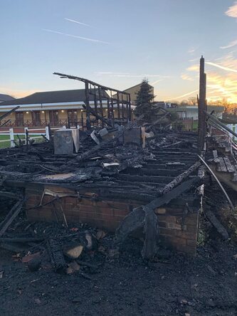
The pavilion has been destroyed
|
6 January 2019 (22:00) - Huge fire rips through Belgrave Commercial Centre, Leicester
Fire crews have been battling a fire at a Belgrave restaurant through the night. Belgrave Road remains closed this morning by emergency services, after a large scale fire in a property in the area, reported by eyewitnesses to be the Belgrave Commercial Centre building containing the Mirch Masala restaurant. At around 10pm on Sunday night emergency services were called to the scene in Belgrave Road. Eight fire appliances plus an arial ladder platform, command support vehicle and incident support unit were sent by Leicestershire Fire and Rescue Service. Police have closed the road to allow fire crews to extinguish the blaze. An alert was posted in the night for people to shut windows and doors due to the amounts of smoke pouring out of the premises. Damping down is currently taking place at the site.
The Belgrave Commercial Centre is on the site of the former British United Shoe Machinery Co Ltd. There is a Blue Plaque located on a wall of Belgrave Commercial Centre to commemorate this. Although not even locally listed, the building is of significant historical importance both for the industrial and social heritage of Leicester.
As the fire broke out late on Sunday night, large crowds were reported to have gathered at the scene of the blaze. Police issued a statement at around 12.45am saying: “Please stay clear of the area for your own safety and to allow for the emergency services to attend the incident.” Stephen Moore, watch manager from Leicestershire fire service said there’s no injuries as far as they are aware. “We’re fighting the fire externally. We’ve recently heard sounds of concrete floors collapsing inside so we’ve gone to defensive mode and we’re just here to make sure the fire doesn’t spread outside the building. We’re waiting for demolition in order to tackle the remaining pockets of fire inside. That’s where we’ll be for the next few hours.”
Krishan Mistry, 24, has lived nearby all his life. He said: “I came home after work at about 10.30pm and then about 11pm it just went up. You could feel the heat, I was shocked because it’s something that has been here for so long and now it’s probably going to be knocked down. It’s devastating.” The owner of Mirch Masala, Nisha Popat, said she believes that the fire started because crates of produce outside a grocery store next door to her restaurant had been set on fire. She said: “Our business was the only one open at the time. I got a call from my staff and drove from my home in Syston. It was like a nightmare. I had staff and customers in there when the fire started and it’s scary. My staff noticed the fire outside when it started - they said crates of deliveries outside the grocery store next door had been set on fire. Then it just went crazy. My staff spotted the flames and got all the customers out and switched off the appliances then left.” She said it was too early to say what the damage was to her restaurant, which she first opened 23 years ago. She added: “There’s obviously been a huge amount of damage. The restaurant is our livelihood.”
Following initial enquiries, the fire is believed to have been started deliberately. An investigation is ongoing. Detective Inspector Mark Parish said: “The incident is being treated as arson and we are investigating to establish the full circumstances of the incident.”
Source: Leicestershire Live

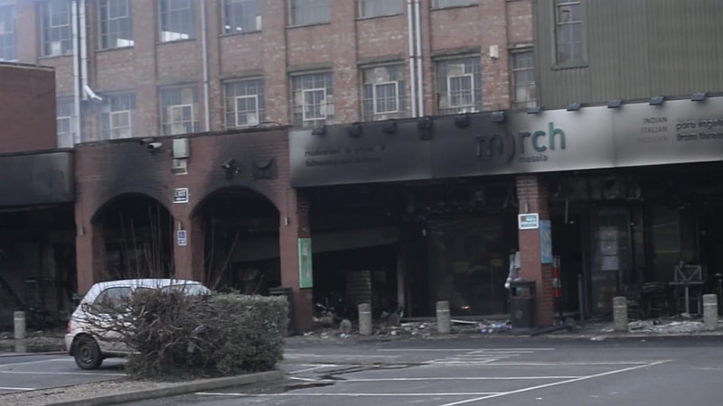
Building History
(Researched by Heritage & Ecclesiastical Fire Protection)
The Belgrave Commercial Centre occupies the last remaining buildings of what was once the vast headquarters and factory workshops of the British United Shoe Machinery (BUSM) company that operated in Belgrave, Leicester from 1899-2000, spanning the 20th Century. It became the largest supplier of shoe making machinery and products in the world, and at its height was Leicester’s largest employer, with more than 4000 staff employed at its Union Works factory which became known locally as the BU.
Most of the workforce was recruited via an apprentice scheme which trained a large proportion of Leicester’s engineers. The company had a respected reputation for technical innovation and excellence. Staff were summoned to work by the factory hooter – something that has passed into history but is remembered by many residents. The BU looked after its workers and provided them not only with work, but with leisure, too. Unlike today, job security was the norm: people weren’t so ambitious or restless and many stayed with the company all their working lives, enjoying local job security.
Like much of British skilled industry, a decline began during the 1970s, prompted by the development of off the shelf hydraulics, pneumatics and electronics which simplified the task facing new competition. This coupled with changes in ownership, resulted in a final messy closure in 2000. The collapse of the company destroyed the pensions of the workers. Their story became one of the most vivid examples of what can go wrong with Private Equity.
In 2007 a planning application was made for 1210 houses on the former site by Trafalgar Global Ltd. The construction of new homes commenced in 2010 with the first residential occupiers of site moving there in 2011. The first phase of the development was completed in 2011 by Westleigh Developments Ltd. The huge chimney was demolished in January 2012.
In 2012 the National Lottery awarded funds to record the social history of BUSM - described as a "powerhouse of British manufacturing" - via a website, DVD and book. Founder member of the BU History Group, Burt McNeill, reflecting on the fact that BUSM operated throughout the twentieth century, described the project as a chance to tell, not just a part of Leicester's history, but of British industrial history. Amongst former BU employees there is an enormous affection and loyalty for the company and the way of life that went with it – a sense of belonging and of satisfaction in doing worthwhile work and being part of the BU community.
The “Golden Mile” refers to the length of the Belgrave Road from its junction with Abbey Park Road to the turning for Loughborough Road. It is actually a very ancient road, roughly following the line of the Roman Fosse Way from Leicester to Newark and Lincoln. There is some debate about what “Golden Mile” refers to. The most popular view is it relates to the many businesses trading in gold and jewellery. The road is also famous for its seasonal lights that celebrate Diwali and Christmas.
5 January 2019 (14:00*) - Fire closes Leeds city centre shop
A fire has closed a Leeds city centre shop this afternoon. The incident has caused substantial damage to the front of the Paperchase store, which is based in a Grade II* listed building in Commercial Street. Shoppers watched on this afternoon as the fire was dealt with and temporary boardings were put up in the shop’s display window.
It appears that no one suffered any serious injuries in the incident. There is a sign in the window informing customers that Paperchase is temporarily shut and redirecting them to their Leeds Train Station branch.
Source: Leeds Live
Update: 7 January 2019 - Managers at the store are currently unable to say when the shop will reopen. They insisted there was no serious damage but the store needs cleaning and the left hand window replacing. The window is completely boarded up and there are signs of closure on the shop doors. People who work in nearby buildings reported that it was cardboard boxes outside the shop's left window that set alight. This has not been confirmed by West Yorkshire Fire and Rescue Service.
Listing Details
|
Entry Name: Numbers 16-20 Including Leeds Library (18)
Listing Date: 19 October 1951 Grade: II* Source: Historic England Source ID: 1375154 English Heritage Legacy ID: 466036 Location: Leeds, LS1 County: Leeds Electoral Ward/Division: City and Hunslet Built-Up Area: Leeds Traditional County: Yorkshire Lieutenancy Area (Ceremonial County): West Yorkshire Church of England Parish: Leeds City Church of England Diocese: Leeds |
Coordinates
Latitude: 53.7975 / 53°47'50"N Longitude: -1.5444 / 1°32'39"W OS Eastings: 430104 OS Northings: 433559 OS Grid: SE301335 Mapcode National: GBR BJL.TH Mapcode Global: WHC9D.7TT4 |
Building History
(Researched by Heritage & Ecclesiastical Fire Protection)
The building was constructed for The Leeds Library, the oldest surviving example of the proprietary subscription library in the British Isles – a library created, owned and run by its members. The library occupies the two floors above the shops. It was founded in 1768, with Joseph Priestly as Secretary. The library moved several times in its early years before settling in the purpose built premises on Commercial Street, Leeds on 4 July 1808.This building is a Grade II* listed Greek Revival building by Thomas Johnson with a major 1880-81 extension to the rear by Thomas Ambler.
The Thoresby Society is the historical society of Leeds and district and was founded in 1889. In 2015 their library moved to the Leeds Library premises.Their collection is built up of material concerned with the history of Leeds and has been amassed over the last 100 years.
5 January 2019 (10.00*) - Police appeal after arson damages church items
Police have renewed an appeal for information after an arson attack at a church. Items in the parish church of St Peter & St Paul on Church Street in Eye were damaged when an offender set fire to a large box of candles which burned out of control.
The church at the centre of the town is Grade I listed and is one of the grandest in Suffolk built in the late 12th century, with a flint-encrusted tower that was rebuilt in the second half of the 15th century, and a historic array of furnishings, rood screen and loft.
The fire occurred sometime between 9.15am and 10.30am on January 5. Police are appealing for information but have said there is no reason to assume other churches may be targeted. However they are warning people to be vigilant and report any suspicious activity. Anyone with information should contact Suffolk Police by calling 101, quoting 37/995/19.
Source: Diss Mercury
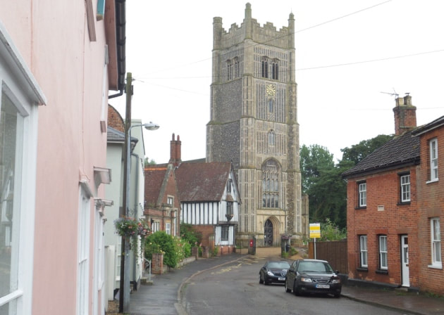
The parish church in Eye suffered damaged items when someone set fire to a large box of candles. (Picture: Andrew Mutimer)
Listing Details
|
Entry Name: Church of St Peter and St Paul
Listing Date: 11 June 1959 Grade: I Source: Historic England Source ID: 1166756 English Heritage Legacy ID: 150491 Location: Eye, Moreton and Ashton, County of Herefordshire, HR6 County: County of Herefordshire Civil Parish: Eye, Moreton and Ashton Traditional County: Herefordshire Lieutenancy Area (Ceremonial County): Herefordshire Church of England Parish: Eye Church of England Diocese: Hereford |
Coordinates
Latitude: 52.2701 / 52°16'12"N Longitude: -2.7394 / 2°44'21"W OS Eastings: 349640 OS Northings: 263810 OS Grid: SO496638 Mapcode National: GBR BK.Z089 Mapcode Global: VH84P.G6NK |
3 January 2019 (18:07) - Huge blaze breaks out at disused North Wing Hospital, Bedford
A Bedford Hospital is engulfed in a huge inferno that broke out from the building’s North Wing. Dramatic photos of plumes of smoke and flames pouring from the hospital windows were shared on social media as bystanders stood back to allow Bedfordshire Fire and Rescue officers to tackle the incident. Firefighters confirmed the hospital is a derelict building after being called to the scene at 6pm this evening. Up to eight fire engines were called to the hospital on Kimbolton Road. Lib Dem councillor Henry Vann said: " Thank you to BedsFire for their bravery; they are currently fighting a serious fire in the old (disused) North Wing Hospital building on Kimbolton Road. The fire looks bad, and fingers-crossed no-one is in there or if they were that everyone is safe, and I hope the fire-crews can get it under control.”
Witnesses lamented the loss of the historic Grade II listed building, with many pointing out they had been born in the ward. A former staff member said: "This is so sad. I’m gutted. Such good memories of working there with everyone.”
A Bedfordshire Fire and Rescue spokesman said: "Bedfordshire Fire and Rescue Service were called to a fire in a derelict building to the rear of the Health Village at Bedford Hospital at 18.07 on Thursday evening (3 January 2019). Eight fire engines are in attendance to tackle the blaze supported by the Bedford and Luton Arial platforms, the Incident Command Centre, two Water Carriers and the Operational Support Unit from Potton. Firefighters are fighting the fire from outside the building and are protecting the surrounding area from the fire. There are no persons reported or casualties. The incident is continuing." In a statement, Bedford Hospital said: "We are aware of the Fire Services currently attending Shires House that is located at Bedford Health Village on Kimbolton Road (formerly North Wing). This is a vacant building and owned by NHS Property Services and not Bedford Hospital. It is very important to clarify that there are no patients or staff within this building."
Source: Express
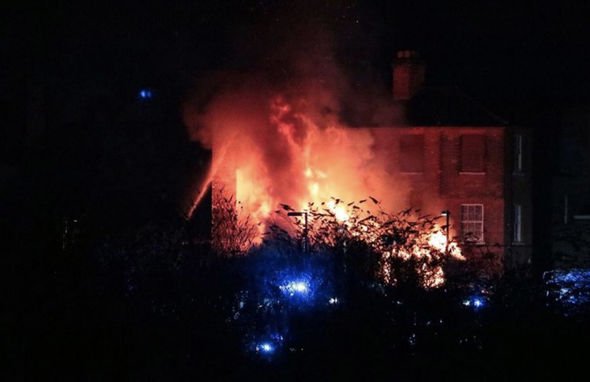
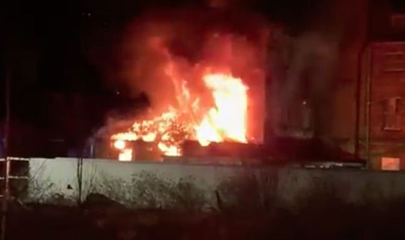
Update: 4 January 2019 - Police hunting suspected arsonist for NHS fire in Bedford
A fire which ripped through an empty health service building near Bedford hospital is being treated as a suspected arson attack. Superintendent Jim Lunn of Bedfordshire Police said, "We take all reports of arson very seriously, particularly as the fire was so close to operational hospital buildings, and we are continuing to investigate the circumstances of this incident. At the moment we are treating this as deliberate. We are keen to find out why this happened and who is responsible, so I’d urge anyone who has information to come forward."
Source: ITV News
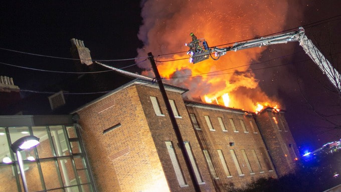
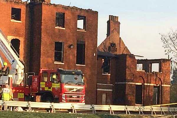
Listing Details
|
Entry Name: Shires House at Bedford Health Village
Listing Date: 14 May 1971 Grade: II Source: Historic England Source ID: 1321009 English Heritage Legacy ID: 35533 Location: Bedford, MK40 County: Bedford County: Warwickshire District: Stratford-on-Avon Civil Parish: Brailes Built-Up Area: Lower Brailes Traditional County: Warwickshire Lieutenancy Area (Ceremonial County): Warwickshire Church of England Parish: Brailes St George Church of England Diocese: Coventry |
Coordinates
Latitude: 52.1416 / 52°8'29"N Longitude: -0.4592 / 0°27'32"W OS Eastings: 505542 OS Northings: 250374 OS Grid: TL055503 Mapcode National: GBR G1Z.QQM Mapcode Global: VHFQ8.0F3L |
Building History
(Researched by Heritage & Ecclesiastical Fire Protection)
Shires House, known locally as the North Wing is a Grade II listed building. In the 1990s North Wing was host to the health authority headquarters, and the maternity and gynaecology unit for Bedford Hospital. In 2006, Shires House closed and has remained empty ever since. But it has an even longer history. The oldest buildings formed The Bedford House of Industry, (Workhouse), built in 1794 – 66, reputedly built with stone from Bedford Castle, and let on perpetual lease to the Guardians in 1835. The architect was John Wing. The manufacture of flannel 'on an extensive scale' took place at the institution. In the early 19th century, a chapel was added to the east end of the building and a central wing was added to the north.
In 1916, an infirmary and lunatic observation wards, designed by H Young, were opened. A nurses' home and other buildings were built after 1924. The 1939 proposed additions to the infirmary do not appear to have been built and the additions to either side are of post-war date. The workhouse closed in 1949 and became Bedford Hospital North Wing under the NHS. The building along with the entire site has had many titles; Bedford Union Workhouse, St Peters Hospital, North Wing Hospital and the latest; North Wing Health Village. The former workhouse was planned to be part of a new healthcare unit, and many of the more recent, and by then derelict, buildings around it were demolished between 2003 -7, but work on the unit came to a stop in 2011.
3 January 2019 (11:40) - Surprise as chimney fire in village pub reveals wasp nest
A fire in the chimney of a village pub has left the management bemused as it revealed a wasp nest buried in the cement, despite it being cleaned recently. Firefighters from Shipston were called to The George Hotel on High Street, Lower Brailes, at around 11.40am this morning (Thursday, January 3), after the chimney caught alight. The blaze was quickly extinguished using chimney rods and buckets – the crew was at the scene for around an hour.
The pub has remained open, but the bar is temporarily closed due to the smoke and smell. Assistant manager Lily Lock said they hope to reopen it this evening but said they found it odd that a wasp nest was in the chimney. “It’s all very strange as the chimney was swept and we had the wasp people over in the summer,” she said. Ms Lock said the fire service believed the fire was caused by a build-up of tar in the chimney so it will be thoroughly swept again in due course.
The George is a Grade II listed late 16th / early 17th century hotel and public house, but was originally a house. It has a carriage entrance and barn attached to left end.
Source: Banbury Guardian
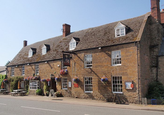
The George is a Grade II listed late 16th / early 17th century hotel and public house
Listing Details
|
Entry Name: George Hotel and Attached Carriage Entrance and Barn
Listing Date: 13 October 1966 Last Amended: 30 June 1986 Grade: II Source: Historic England Source ID: 1185466 English Heritage Legacy ID: 305810 Location: Brailes, Stratford-on-Avon, Warwickshire, OX15 County: Warwickshire District: Stratford-on-Avon Civil Parish: Brailes Built-Up Area: Lower Brailes Traditional County: Warwickshire Lieutenancy Area (Ceremonial County): Warwickshire Church of England Parish: Brailes St George Church of England Diocese: Coventry |
Coordinates
Latitude: 52.051 / 52°3'3"N Longitude: -1.5432 / 1°32'35"W OS Eastings: 431418 OS Northings: 239272 OS Grid: SP314392 Mapcode National: GBR 6RF.6NT Mapcode Global: VHBYP.6QH3 |
3 January 2019 (09:00*) - Chimney catches fire at Abbotsbury pub
Fire crews from Dorchester have been tackling a chimney blaze, which broke out on Thursday morning. It happened at the Ilchester Arms pub in Market Street, Abbotsbury. The blaze was confined to the chimney. No one was injured.
A spokesman for Dorchester fire station said: "In this instance it was clear that the landlords keep the chimney in very good condition and have it swept very regularly. It goes to show that even immaculate chimney flues are still at risk from fires catching where they shouldn’t."
The Ilchester Arms is a Grade II listed 17th century coaching inn.
Source: Wessex FM
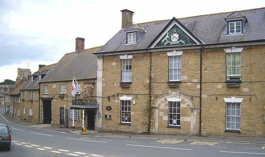
The Illchester Arms is a 17th century coaching inn in Abbotsbury
|
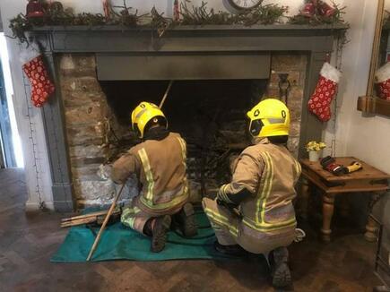
Firefighters use a chimney kit to extinguish the flames (Picture: Dorchester Fire Station)
|
Listing Details
|
Entry Name: Ilchester Arms Hotel
Listing Date: 26 January 1956 Grade: II Source: Historic England Source ID: 1172420 English Heritage Legacy ID: 105156 Location: Abbotsbury, West Dorset, Dorset, DT3 County: Dorset District: West Dorset Civil Parish: Abbotsbury Built-Up Area: Abbotsbury Traditional County: Dorset Lieutenancy Area (Ceremonial County): Dorset Church of England Parish: Abbotsbury St Nicholas Church of England Diocese: Salisbury |
Coordinates
Latitude: 50.6663 / 50°39'58"N Longitude: -2.6004 / 2°36'1"W OS Eastings: 357660 OS Northings: 85348 OS Grid: SY576853 Mapcode National: GBR PT.6RQR Mapcode Global: FRA 57F9.YJ4 |
2 January 2019 (12:40) - Chimney fire at Ye Olde Red Horse pub
Firefighters were called to a pub today (Wednesday, January 2) to attend a chimney fire. The fire was at Ye Olde Red Horse pub, Vine street, Evesham. Staff called emergency services at 12:40 and one fire crew from Evesham attended. The fire was extinguished using chimney rods and other small tools. Fire fighters will return to the pub this afternoon to check the chimney again, which is normal practice when dealing with chimney fires.
The historical, timber-framed 15th century coaching inn and one of the oldest hostelries in the Vale of Evesham and is Grade II listed. The lounge has an area set aside for dining where there are many features linked to the historic Evesham Abbey.
Source: Evesham Journal
The historical, timber-framed 15th century coaching inn and one of the oldest hostelries in the Vale of Evesham and is Grade II listed. The lounge has an area set aside for dining where there are many features linked to the historic Evesham Abbey.
Source: Evesham Journal
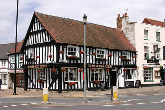
Ye Olde Red Horse is a 15th century coaching inn.
Listing Details
|
Entry Name: Old Red Horse Inn
Listing Date: 7 May 1952 Grade: II Source: Historic England Source ID: 1081340 English Heritage Legacy ID: 147547 Location: Evesham, Wychavon, Worcestershire, WR11 County: Worcestershire District: Wychavon Civil Parish: Evesham Built-Up Area: Evesham Traditional County: Worcestershire Lieutenancy Area (Ceremonial County): Worcestershire Church of England Parish: Evesham All Saints with St Lawrence Church of England Diocese: Worcester |
Coordinates
Latitude: 52.0917 / 52°5'29"N Longitude: -1.949 / 1°56'56"W OS Eastings: 403587 OS Northings: 243701 OS Grid: SP035437 Mapcode National: GBR 3LB.S2X Mapcode Global: VHB0T.5PGD |
Phone: 07840 351458 Email: hello@fireprotect.me.uk
Deeside, Flintshire, North Wales, CH5 1PE
Heritage & Ecclesiastical Fire Protection is a trading style of Dragon Fire Safety
Heritage & Ecclesiastical Fire Protection is a trading style of Dragon Fire Safety
